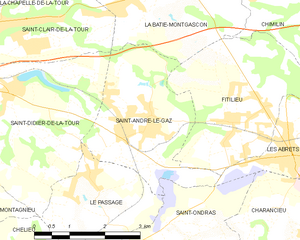
Saint-Didier-de-la-Tour (Saint-Didier-de-la-Tour)

- commune in Isère, France
 Hiking in Saint-Didier-de-la-Tour
Saint-Didier-de-la-Tour is a charming commune located in the Isère department of the Auvergne-Rhône-Alpes region in southeastern France. The area is characterized by its natural beauty, including rolling hills, lush greenery, and proximity to the mountains, making it a great spot for hiking enthusiasts.
Hiking Trails and Routes
-
Local Trails: There are several local trails that allow hikers to explore the immediate surroundings. These trails often take you through picturesque landscapes filled with meadows, forests, and panoramic views of the Chartreuse and Belledonne mountain ranges.
-
GR Trails: Larger hiking routes such as the Grande Randonnée (GR) trails may be accessible from the area, leading to longer hikes with varying levels of difficulty. These trails are well-marked and can connect you to other nearby towns and natural sites.
-
Natural Reserves: The nearby natural reserves and parks, like the Chartreuse Regional Nature Park, offer extensive networks of hiking paths, ranging from easy walks suitable for families to challenging treks for more experienced hikers.
Considerations
- Weather: Be sure to check the weather forecast before heading out, as conditions can change rapidly in mountainous areas.
- Equipment: Proper hiking gear, including sturdy boots, appropriate clothing, and navigation tools (maps or GPS), is essential for a safe and enjoyable experience.
- Wildlife: The region is home to diverse wildlife, so keep an eye out, but also respect nature and maintain distance from animals.
Tips for Hikers
- Plan Ahead: Always inform someone about your hiking plans and estimated return time.
- Pack Essentials: Bring enough water, snacks, and a basic first-aid kit to be prepared for your hike.
- Leave No Trace: Practice eco-friendly hiking by packing out what you bring in and staying on marked trails.
Local Culture
Saint-Didier-de-la-Tour offers a glimpse into the local culture, with potential opportunities to sample regional cuisine and learn about the area's history, particularly after a day on the trails.
Whether you're looking for a short stroll or a more extensive hike, Saint-Didier-de-la-Tour provides an excellent base for exploring the natural beauty of the region. Enjoy your hiking adventure!
- Country:

- Postal Code: 38110
- Coordinates: 45° 33' 19" N, 5° 28' 59" E


- GPS tracks (wikiloc): [Link]
- Area: 14.63 sq km
- Population: 2003
- Web site: http://www.saintdidierdelatour.fr
- Wikipedia en: wiki(en)
- Wikipedia: wiki(fr)
- Wikidata storage: Wikidata: Q1067763
- Wikipedia Commons Category: [Link]
- Freebase ID: [/m/03nvj1c]
- GeoNames ID: Alt: [6433338]
- SIREN number: [213803810]
- BnF ID: [15258191k]
- INSEE municipality code: 38381
Shares border with regions:


Saint-Clair-de-la-Tour
- commune in Isère, France
Hiking in Saint-Clair-de-la-Tour
Saint-Clair-de-la-Tour, located in the Auvergne-Rhône-Alpes region of France, offers some beautiful hiking opportunities amid its scenic landscapes. Here are some highlights if you're considering hiking in the area:...
- Country:
- Postal Code: 38110
- Coordinates: 45° 34' 26" N, 5° 28' 55" E
- GPS tracks (wikiloc): [Link]
- Area: 9.24 sq km
- Population: 3365
- Web site: [Link]

Saint-André-le-Gaz
- commune in Isère, France
Hiking in Saint-André-le-Gaz
Saint-André-le-Gaz, located in the Auvergne-Rhône-Alpes region of France, offers a delightful experience for hikers and outdoor enthusiasts. Nestled at the foothills of the Chartreuse Mountains and near the Rhône Valley, this area provides a range of trails suitable for various skill levels, from leisurely walks to more challenging hikes....
- Country:
- Postal Code: 38490
- Coordinates: 45° 32' 56" N, 5° 32' 3" E
- GPS tracks (wikiloc): [Link]
- Area: 8.89 sq km
- Population: 2783
- Web site: [Link]

Sainte-Blandine
- commune in Isère, France
Hiking in Sainte-Blandine
Sainte-Blandine, located in the Isère department of the Auvergne-Rhône-Alpes region in southeastern France, is a charming village surrounded by beautiful natural landscapes ideal for hiking enthusiasts. Here are some highlights and tips for hiking in the area:...
- Country:
- Postal Code: 38110
- Coordinates: 45° 32' 48" N, 5° 26' 26" E
- GPS tracks (wikiloc): [Link]
- Area: 9.21 sq km
- Population: 963

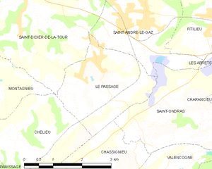
Le Passage
- commune in Isère, France
Hiking in Le Passage
Le Passage is a small village located in the Isère department of the Auvergne-Rhône-Alpes region in southeastern France. While it may not be as widely recognized as some larger hiking destinations, the surrounding Isère region offers a wealth of hiking opportunities, particularly in the nearby Vercors and Chartreuse mountain ranges....
- Country:
- Postal Code: 38490
- Coordinates: 45° 31' 58" N, 5° 30' 43" E
- GPS tracks (wikiloc): [Link]
- Area: 6.68 sq km
- Population: 783
- Web site: [Link]

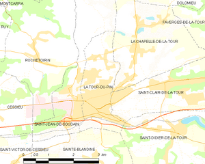
La Tour-du-Pin
- commune in Isère, France
Hiking in La Tour-du-Pin
La Tour-du-Pin is a charming town located in the Isère department of the Auvergne-Rhône-Alpes region in southeastern France. Its proximity to the French Alps and various natural parks makes it an excellent spot for hiking enthusiasts....
- Country:
- Postal Code: 38110
- Coordinates: 45° 33' 57" N, 5° 26' 42" E
- GPS tracks (wikiloc): [Link]
- Area: 4.77 sq km
- Population: 7970
- Web site: [Link]


Montagnieu
- commune in Isère, France
Hiking in Montagnieu
Montagnieu, located in the department of Isère in the Auvergne-Rhône-Alpes region of France, offers a variety of hiking options that showcase the natural beauty of the surrounding landscapes. Here are some key points about hiking in this area:...
- Country:
- Postal Code: 38110
- Coordinates: 45° 31' 27" N, 5° 27' 9" E
- GPS tracks (wikiloc): [Link]
- Area: 8.83 sq km
- Population: 1023