Le Pondy (Le Pondy)

- commune in Cher, France
- Country:

- Postal Code: 18210
- Coordinates: 46° 48' 15" N, 2° 38' 58" E


- GPS tracks (wikiloc): [Link]
- Area: 6.63 sq km
- Population: 139
- Wikipedia en: wiki(en)
- Wikipedia: wiki(fr)
- Wikidata storage: Wikidata: Q1409911
- Wikipedia Commons Category: [Link]
- Freebase ID: [/m/03mfdmw]
- GeoNames ID: Alt: [6455655]
- SIREN number: [211801832]
- BnF ID: [152495299]
- Quora topic ID: [Le-Pondy-1]
- INSEE municipality code: 18183
Shares border with regions:

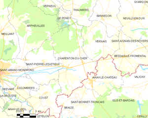
Charenton-du-Cher
- commune in Cher, France
- Country:
- Postal Code: 18210
- Coordinates: 46° 43' 47" N, 2° 38' 32" E
- GPS tracks (wikiloc): [Link]
- Area: 47.89 sq km
- Population: 1082


Thaumiers
- commune in Cher, France
- Country:
- Postal Code: 18210
- Coordinates: 46° 49' 17" N, 2° 39' 18" E
- GPS tracks (wikiloc): [Link]
- Area: 27.33 sq km
- Population: 415
- Web site: [Link]

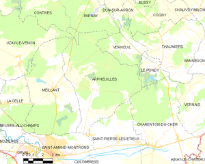
Arpheuilles
- commune in Cher, France
- Country:
- Postal Code: 18200
- Coordinates: 46° 46' 57" N, 2° 33' 38" E
- GPS tracks (wikiloc): [Link]
- Area: 48.01 sq km
- Population: 301
Verneuil
- commune in Cher, France
- Country:
- Postal Code: 18210
- Coordinates: 46° 49' 1" N, 2° 36' 16" E
- GPS tracks (wikiloc): [Link]
- Area: 11.04 sq km
- Population: 35