Le Roc-Saint-André (Le Roc-Saint-André)

- former commune in Morbihan, France
- Country:

- Postal Code: 56460
- Coordinates: 47° 51' 53" N, 2° 26' 56" E


- GPS tracks (wikiloc): [Link]
- Area: 9.93 sq km
- Population: 917
- Web site: http://www.ville-roc-saint-andre.fr
- Wikipedia en: wiki(en)
- Wikipedia: wiki(fr)
- Wikidata storage: Wikidata: Q128935
- Wikipedia Commons Category: [Link]
- Freebase ID: [/m/03cb3mj]
- GeoNames ID: Alt: [6456218]
- BnF ID: [152654462]
- VIAF ID: Alt: [141162847]
- INSEE municipality code: 56197
Shares border with regions:

Guillac
- commune in Morbihan, France
- Country:
- Postal Code: 56800
- Coordinates: 47° 54' 38" N, 2° 27' 58" E
- GPS tracks (wikiloc): [Link]
- Area: 21.83 sq km
- Population: 1376
- Web site: [Link]


Ploërmel
- commune in Morbihan, France
- Country:
- Postal Code: 56800
- Coordinates: 47° 55' 54" N, 2° 23' 51" E
- GPS tracks (wikiloc): [Link]
- AboveSeaLevel: 75 м m
- Area: 57.82 sq km
- Population: 9571
- Web site: [Link]


Quily
- former commune in Morbihan, France
- Country:
- Postal Code: 56800
- Coordinates: 47° 53' 27" N, 2° 28' 5" E
- GPS tracks (wikiloc): [Link]
- Area: 5.39 sq km
- Population: 355

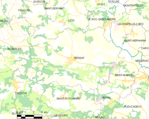
Sérent
- commune in Morbihan, France
- Country:
- Postal Code: 56460
- Coordinates: 47° 49' 23" N, 2° 30' 21" E
- GPS tracks (wikiloc): [Link]
- Area: 59.67 sq km
- Population: 3053
- Web site: [Link]


La Chapelle-Caro
- former commune in Morbihan, France
- Country:
- Postal Code: 56460
- Coordinates: 47° 51' 55" N, 2° 25' 23" E
- GPS tracks (wikiloc): [Link]
- Area: 16.49 sq km
- Population: 1380
- Web site: [Link]

Lizio
- commune in Morbihan, France
- Country:
- Postal Code: 56460
- Coordinates: 47° 51' 47" N, 2° 31' 34" E
- GPS tracks (wikiloc): [Link]
- Area: 16.96 sq km
- Population: 737
- Web site: [Link]


Montertelot
- commune in Morbihan, France
- Country:
- Postal Code: 56800
- Coordinates: 47° 52' 50" N, 2° 25' 19" E
- GPS tracks (wikiloc): [Link]
- Area: 2.64 sq km
- Population: 364