Le Temple (Le Temple)

- commune in Loir-et-Cher, France
- Country:

- Postal Code: 41170
- Coordinates: 47° 55' 56" N, 0° 56' 5" E


- GPS tracks (wikiloc): [Link]
- AboveSeaLevel: 163 м m
- Area: 13.32 sq km
- Population: 184
- Wikipedia en: wiki(en)
- Wikipedia: wiki(fr)
- Wikidata storage: Wikidata: Q1383796
- Wikipedia Commons Category: [Link]
- Freebase ID: [/m/03qd2lp]
- GeoNames ID: Alt: [6616754]
- SIREN number: [214102543]
- BnF ID: [152595285]
- INSEE municipality code: 41254
Shares border with regions:
Cormenon
- commune in Loir-et-Cher, France
- Country:
- Postal Code: 41170
- Coordinates: 47° 58' 6" N, 0° 53' 37" E
- GPS tracks (wikiloc): [Link]
- Area: 5.76 sq km
- Population: 699

Choue
- commune in Loir-et-Cher, France
- Country:
- Postal Code: 41170
- Coordinates: 47° 59' 55" N, 0° 55' 42" E
- GPS tracks (wikiloc): [Link]
- Area: 37.39 sq km
- Population: 529
Beauchêne
- commune in Loir-et-Cher, France
- Country:
- Postal Code: 41170
- Coordinates: 47° 56' 26" N, 0° 58' 10" E
- GPS tracks (wikiloc): [Link]
- AboveSeaLevel: 176 м m
- Area: 10.08 sq km
- Population: 190

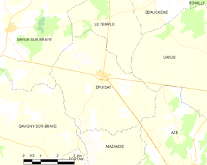
Épuisay
- commune in Loir-et-Cher, France
- Country:
- Postal Code: 41360
- Coordinates: 47° 54' 1" N, 0° 55' 53" E
- GPS tracks (wikiloc): [Link]
- Area: 23.52 sq km
- Population: 819
Saint-Marc-du-Cor
- commune in Loir-et-Cher, France
- Country:
- Postal Code: 41170
- Coordinates: 47° 58' 16" N, 0° 57' 12" E
- GPS tracks (wikiloc): [Link]
- Area: 13.09 sq km
- Population: 186

Danzé
- commune in Loir-et-Cher, France
- Country:
- Postal Code: 41160
- Coordinates: 47° 53' 35" N, 1° 1' 40" E
- GPS tracks (wikiloc): [Link]
- Area: 42.26 sq km
- Population: 705

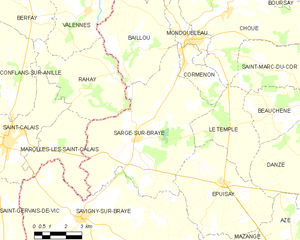
Sargé-sur-Braye
- commune in Loir-et-Cher, France
- Country:
- Postal Code: 41170
- Coordinates: 47° 55' 25" N, 0° 51' 11" E
- GPS tracks (wikiloc): [Link]
- Area: 42.61 sq km
- Population: 1054