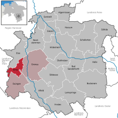
Leinebergland (Samtgemeinde Leinebergland)
Leinebergland, located in the Samtgemeinde in Lower Saxony, Germany, offers a beautiful setting for hiking enthusiasts. The region features a mix of scenic landscapes, including rolling hills, dense forests, and charming villages. Here are some highlights of hiking in this area:
-
Diverse Trails: Leinebergland offers a variety of hiking trails suitable for different skill levels, from easy strolls to challenging hikes. Popular routes can take you through picturesque valleys, along rivers, and up to viewpoints with stunning vistas.
-
Nature and Wildlife: The region is rich in flora and fauna. You might encounter different species of birds, wildflowers, and other wildlife along the trails, making it an excellent destination for nature lovers and birdwatchers.
-
Cultural Landmarks: While hiking, you can explore historical landmarks and quaint villages, providing a cultural experience alongside your outdoor adventure. You may come across old half-timbered houses, churches, and local farms.
-
Waymarked Trails: Many trails in the area are well-marked, making navigation easier. Look for signs indicating the paths and distances to ensure you stay on track.
-
Recommended Routes: Some popular hiking routes include:
- The Harzer Wandernadel: A network of trails linking various points of interest in the Harz region.
- Circular trails around the towns of Einbeck or Northeim offer a mix of nature and cultural experiences.
-
Seasonal Changes: The beauty of Leinebergland changes with the seasons, so every time you hike, you may experience something new – from lush greenery in spring and summer to vibrant autumn colors.
-
Facilities and Accommodations: The area has numerous facilities for hikers, including guesthouses and restaurants where you can enjoy local cuisine after a day on the trails.
-
Safety Tips: As with any hiking adventure, it's important to wear suitable footwear, carry enough water, and be aware of the weather conditions. Always inform someone about your hiking plans.
Leinebergland is an excellent choice for both day hikers and those looking to explore longer trails. With its rich natural beauty and cultural heritage, it’s a hidden gem for outdoor enthusiasts.
- Country:

- Coordinates: 52° 4' 0" N, 9° 47' 0" E


- GPS tracks (wikiloc): [Link]
- Population: 18474
- Wikipedia en: wiki(en)
- Wikipedia: wiki(de)
- Wikidata storage: Wikidata: Q19308430
Includes regions:


Gronau (Leine)
- municipality of Germany
Gronau, located in Lower Saxony, Germany, offers a variety of hiking opportunities that showcase the area's natural beauty and scenic landscapes. While Gronau itself may not be as famous for hiking as some other regions in Germany, it serves as a good starting point for exploring the surrounding areas. Here are some highlights regarding hiking in and around Gronau:...
- Country:

- Postal Code: 31028
- Local Dialing Code: 05182
- Licence Plate Code: HI
- Coordinates: 52° 5' 0" N, 9° 47' 0" E


- GPS tracks (wikiloc): [Link]
- AboveSeaLevel: 81 м m
- Area: 88.13 sq km
- Population: 10852
- Web site: [Link]


Duingen
- municipality of Germany
Duingen is a charming small town located in Lower Saxony, Germany, surrounded by beautiful landscapes that are perfect for hiking enthusiasts. While it may not be as widely recognized as some of the larger hiking destinations, Duingen offers a variety of trails and scenic views that make it an appealing spot for outdoor activities....
- Country:

- Postal Code: 31089
- Local Dialing Code: 05185
- Licence Plate Code: HI
- Coordinates: 52° 0' 16" N, 9° 41' 45" E


- GPS tracks (wikiloc): [Link]
- AboveSeaLevel: 204 м m
- Area: 59.62 sq km
- Population: 4944
- Web site: [Link]

Eime
- municipality of Germany
Eime is a small municipality located in Lower Saxony, Germany, often characterized by its beautiful natural landscapes and charming surroundings. While not as widely known for hiking as some larger national parks or famous trails, Eime offers some lovely opportunities for outdoor enthusiasts looking to explore the region....
- Country:

- Postal Code: 31036
- Local Dialing Code: 05182
- Licence Plate Code: HI
- Coordinates: 52° 4' 59" N, 9° 43' 0" E


- GPS tracks (wikiloc): [Link]
- AboveSeaLevel: 89 м m
- Area: 21.93 sq km
- Population: 2588
- Web site: [Link]
