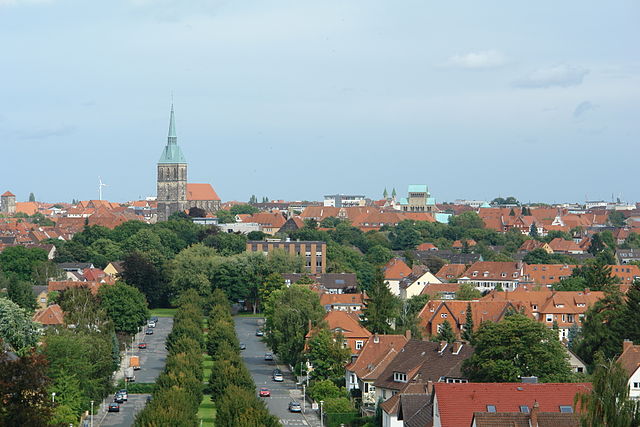
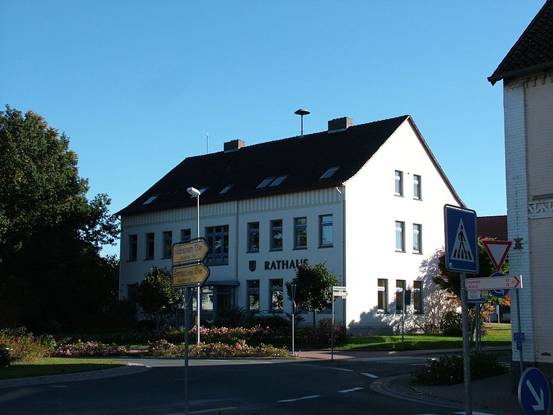
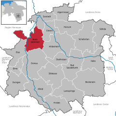
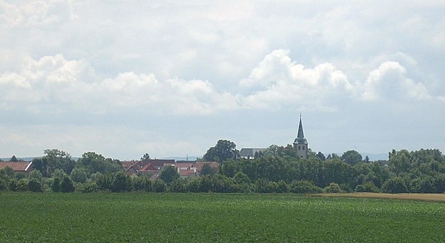
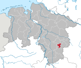
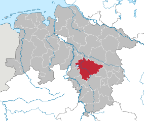
Hildesheim (Landkreis Hildesheim)

- district in Lower Saxony, Germany
 Hiking in Hildesheim
Hildesheim is a beautiful district in Lower Saxony, Germany, known for its rich cultural heritage and scenic landscapes. While it may not be as famous for hiking as some other regions in Germany, there are still several great options for hikers of various skill levels.
Hiking Trails
-
Landschaftsschutzgebiet Lichtenberg: This is a notable area for hiking, featuring rolling hills, forests, and fields. The trails here often provide beautiful views of the surrounding countryside.
-
Hildesheimer Wald: The Hildesheim Forest offers a network of paths that wind through a diverse landscape of forests and meadows. It's an excellent area for walking, running, and cycling, with routes suitable for families.
-
Nienberger Berg: Located near the town, this area has several trails that offer an easier hiking experience while providing pleasant views.
-
The Harz Mountains: Although not directly in Hildesheim, the Harz region is a popular destination for hiking and is accessible within a short drive. The Harz offers numerous trails with varying difficulty levels, including the well-known Brocken, the highest peak in Northern Germany.
Tips for Hiking in Hildesheim
- Prepare for the Weather: The weather can be unpredictable in Lower Saxony, so pack layers and waterproof clothing.
- Stay Hydrated: Bring enough water, especially on longer hikes.
- Trail Maps: Consider obtaining a map or using a hiking app to navigate the trails.
- Respect Nature: Follow the principles of Leave No Trace, ensuring you preserve the beauty of the natural environment.
- Local Regulations: Be aware of any local regulations regarding hiking in certain areas, particularly in wildlife conservation regions.
Conclusion
Hiking in Hildesheim can be a delightful experience, with opportunities to enjoy nature, discover local flora and fauna, and explore the tranquil countryside. Whether you’re a beginner or an experienced hiker, there's something for everyone in this charming district.
- Country:

- Capital: Hildesheim
- Licence Plate Code: HI; ALF
- Coordinates: 52° 4' 48" N, 9° 55' 12" E


- GPS tracks (wikiloc): [Link]
- AboveSeaLevel: 80 м m
- Area: 1206.00 sq km
- Population: 277300
- Web site: http://www.landkreishildesheim.de
- Wikipedia en: wiki(en)
- Wikipedia: wiki(de)
- Wikidata storage: Wikidata: Q5978
- Wikipedia Commons Category: [Link]
- Wikipedia Commons Maps Category: [Link]
- Freebase ID: [/m/013_dx]
- Freebase ID: [/m/013_dx]
- GeoNames ID: Alt: [2803461]
- GeoNames ID: Alt: [2803461]
- VIAF ID: Alt: [312795130]
- VIAF ID: Alt: [312795130]
- OSM relation ID: [62742]
- OSM relation ID: [62742]
- GND ID: Alt: [4024885-9]
- GND ID: Alt: [4024885-9]
- archINFORM location ID: [2458]
- archINFORM location ID: [2458]
- Library of Congress authority ID: Alt: [n79098646]
- Library of Congress authority ID: Alt: [n79098646]
- TGN ID: [7077537]
- TGN ID: [7077537]
- National Library of Israel ID: [000976602]
- National Library of Israel ID: [000976602]
- NUTS code: [DE925]
- NUTS code: [DE925]
- German district key: 03254
- German district key: 03254
Includes regions:

Leinebergland
Hiking in Leinebergland
Leinebergland, located in the Samtgemeinde in Lower Saxony, Germany, offers a beautiful setting for hiking enthusiasts. The region features a mix of scenic landscapes, including rolling hills, dense forests, and charming villages. Here are some highlights of hiking in this area:...
- Country:
- Coordinates: 52° 4' 0" N, 9° 47' 0" E
- GPS tracks (wikiloc): [Link]
- Population: 18474

Gronau
- Samtgemeinde in Lower Saxony
Hiking in Gronau
Gronau, located in the Samtgemeinde of Gronau in Lower Saxony, Germany, may not be as well-known for its hiking trails compared to more mountainous regions, but it offers a charming landscape for outdoor enthusiasts. The area is characterized by scenic views, lush countryside, and various pathways suitable for hiking and walking....
- Country:
- Coordinates: 52° 4' 0" N, 9° 47' 0" E
- GPS tracks (wikiloc): [Link]


Diekholzen
- municipality of Germany
Hiking in Diekholzen
Diekholzen is a charming village located near the city of Hildesheim in Lower Saxony, Germany. It offers beautiful landscapes and a variety of trails that are perfect for hiking enthusiasts. Here are some highlights regarding hiking in Diekholzen:...
- Country:
- Postal Code: 31199
- Local Dialing Code: 05121
- Licence Plate Code: HI
- Coordinates: 52° 6' 0" N, 9° 56' 0" E
- GPS tracks (wikiloc): [Link]
- AboveSeaLevel: 118 м m
- Area: 30.21 sq km
- Population: 6476
- Web site: [Link]

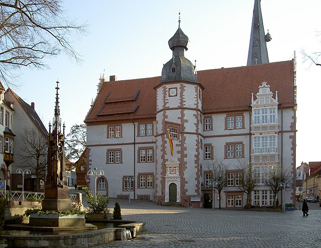
Hildesheim
- German city
Hiking in Hildesheim
Hildesheim, located in Lower Saxony, Germany, offers a variety of hiking opportunities that cater to different skill levels and interests. The region is rich in natural beauty, historic sites, and charming villages. Here are some highlights for hiking in and around Hildesheim:...
- Country:
- Postal Code: 31101–31141
- Local Dialing Code: 05121
- Licence Plate Code: HI
- Coordinates: 52° 9' 0" N, 9° 57' 0" E
- GPS tracks (wikiloc): [Link]
- AboveSeaLevel: 78 м m
- Area: 92.29 sq km
- Population: 101701
- Web site: [Link]

Freden
- former Samtgemeinde in Lower Saxony
Hiking in Freden
Freden is a charming municipality located in the Samtgemeinde of Freden, situated in Lower Saxony, Germany. Though it may not be as well-known as some other hiking destinations in Germany, it offers some delightful trails and scenic landscapes for outdoor enthusiasts....

Alfeld
- municipality of Germany in Lower Saxony
Hiking in Alfeld
Alfeld, located in Lower Saxony, Germany, offers a charming setting for hiking enthusiasts. The region is known for its diverse landscapes, rich natural beauty, and a variety of trails suitable for different skill levels. Here are some highlights of hiking in and around Alfeld:...
- Country:
- Postal Code: 31061
- Local Dialing Code: 05181
- Coordinates: 51° 59' 19" N, 9° 49' 37" E
- GPS tracks (wikiloc): [Link]
- AboveSeaLevel: 145 м m
- Area: 72.86 sq km
- Population: 19061
- Web site: [Link]

Bockenem
- municipality of Germany
Hiking in Bockenem
Bockenem, located in Lower Saxony, Germany, is a charming small town surrounded by beautiful natural landscapes, making it a great destination for hiking enthusiasts. Here are some highlights and tips for hiking in and around Bockenem:...
- Country:
- Postal Code: 31167
- Local Dialing Code: 05067
- Licence Plate Code: HI
- Coordinates: 52° 0' 36" N, 10° 7' 55" E
- GPS tracks (wikiloc): [Link]
- AboveSeaLevel: 122 м m
- Area: 109.04 sq km
- Population: 9827
- Web site: [Link]


Elze
- municipality of Germany
Hiking in Elze
Elze is a small town located in Lower Saxony, Germany, known for its scenic landscapes and access to natural areas. While it may not be as famous as some larger hiking destinations, Elze and its surrounding region offer a variety of hiking opportunities for both novice and experienced hikers....
- Country:
- Postal Code: 31008
- Local Dialing Code: 05068
- Licence Plate Code: HI
- Coordinates: 52° 7' 21" N, 9° 44' 9" E
- GPS tracks (wikiloc): [Link]
- AboveSeaLevel: 93 м m
- Area: 47.71 sq km
- Population: 8858
- Web site: [Link]

Harsum
- municipality of Germany
Hiking in Harsum
Harsum, located in Lower Saxony, Germany, is a charming area that offers various outdoor activities, including hiking. While it may not be as well-known as some larger hiking destinations, there are several trails and natural areas worth exploring....
- Country:
- Postal Code: 31177
- Local Dialing Code: 05128; 05127
- Licence Plate Code: HI
- Coordinates: 52° 12' 0" N, 9° 57' 0" E
- GPS tracks (wikiloc): [Link]
- AboveSeaLevel: 70 м m
- Area: 49.93 sq km
- Population: 11367
- Web site: [Link]

Sibbesse
- Samtgemeinde in Lower Saxony
Hiking in Sibbesse
Sibbesse, located in the Samtgemeinde of Sibbesse in Lower Saxony, Germany, offers a variety of hiking opportunities that showcase the beautiful landscapes of the region. The area is characterized by rolling hills, lush forests, and charming rural scenery, making it a pleasant destination for hikers of all skill levels....
Duingen
- Samtgemeinde in Lower Saxony
Hiking in Duingen
Duingen, located in the Samtgemeinde of the Lower Saxony region in Germany, offers a charming setting for hiking enthusiasts. While it may not be as well-known as some other hiking destinations, it features beautiful landscapes, woodlands, and quiet rural paths that offer a peaceful experience amidst nature....
Lamspringe
- Samtgemeinde in Lower Saxony
Hiking in Lamspringe
Lamspringe, located in the Samtgemeinde in Lower Saxony, Germany, is a beautiful area that offers a variety of hiking opportunities amidst picturesque landscapes. Here’s an overview of hiking in Lamspringe and its surroundings:...
Nordstemmen
- municipality of Germany
Hiking in Nordstemmen
Nordstemmen is a small town in Lower Saxony, Germany, located near the larger city of Hannover. While it may not be as widely recognized as hiking destinations like the Harz Mountains, there are still excellent hiking opportunities in and around this area....
- Country:
- Postal Code: 31171
- Local Dialing Code: 05069
- Licence Plate Code: HI
- Coordinates: 52° 9' 43" N, 9° 47' 1" E
- GPS tracks (wikiloc): [Link]
- AboveSeaLevel: 76 м m
- Area: 60.17 sq km
- Population: 12119
- Web site: [Link]


Sarstedt
- municipality of Germany
Hiking in Sarstedt
Sarstedt, located in the Lower Saxony region of Germany, offers a variety of hiking opportunities that are great for both novice and experienced hikers. While the immediate area may not have the dramatic landscapes found in other parts of Germany, it provides a charming environment with scenic trails and beautiful natural surroundings....
- Country:
- Postal Code: 31157
- Local Dialing Code: 05066
- Licence Plate Code: HI
- Coordinates: 52° 14' 22" N, 9° 51' 38" E
- GPS tracks (wikiloc): [Link]
- AboveSeaLevel: 64 м m
- Area: 42.94 sq km
- Population: 19262
- Web site: [Link]


Holle
- municipality of Germany
Hiking in Holle
Holle is a municipality in the Lower Saxony region of Germany, and it offers various outdoor activities, including hiking. While Holle might not be as famous as some larger hiking destinations, it provides access to picturesque scenery and trails that can be enjoyed by both casual walkers and more experienced hikers....
- Country:
- Postal Code: 31188
- Local Dialing Code: 05062
- Licence Plate Code: HI
- Coordinates: 52° 5' 30" N, 10° 9' 30" E
- GPS tracks (wikiloc): [Link]
- AboveSeaLevel: 116 м m
- Area: 61.15 sq km
- Population: 7073
- Web site: [Link]


Söhlde
- municipality of Germany
Hiking in Söhlde
Söhlde is a small municipality located in Lower Saxony, Germany. While it may not be widely known for hiking, the surrounding region offers some scenic trails that can be quite enjoyable for hikers of various skill levels. Here's what you might find interesting if you plan to hike in or around Söhlde:...
- Country:
- Postal Code: 31185
- Local Dialing Code: 05129
- Licence Plate Code: HI
- Coordinates: 52° 12' 0" N, 10° 14' 0" E
- GPS tracks (wikiloc): [Link]
- AboveSeaLevel: 94 м m
- Area: 57.09 sq km
- Population: 7801
- Web site: [Link]

Algermissen
- municipality of Germany
Hiking in Algermissen
Algermissen is a small municipality located in Lower Saxony, Germany. While it may not be as well-known for hiking as larger natural parks or mountainous regions, there are still opportunities for outdoor activities in and around the area....
- Country:
- Postal Code: 31191
- Local Dialing Code: 05126
- Licence Plate Code: HI
- Coordinates: 52° 15' 12" N, 9° 58' 9" E
- GPS tracks (wikiloc): [Link]
- AboveSeaLevel: 79 м m
- Area: 35.62 sq km
- Population: 7840
- Web site: [Link]


Bad Salzdetfurth
- town in the District of Hildesheim, Lower Saxony, Germany
Hiking in Bad Salzdetfurth
Bad Salzdetfurth, located in Lower Saxony, Germany, is a charming town known for its rich history and beautiful landscapes. It's an excellent destination for hiking enthusiasts. Here’s what you can expect when hiking in the area:...
- Country:
- Postal Code: 31162
- Local Dialing Code: 05064; 05060; 05063
- Licence Plate Code: HI
- Coordinates: 52° 3' 28" N, 10° 0' 21" E
- GPS tracks (wikiloc): [Link]
- AboveSeaLevel: 110 м m
- Area: 67.11 sq km
- Population: 13281
- Web site: [Link]


Giesen
- municipality of Germany
Hiking in Giesen
Giesen, located in Lower Saxony, Germany, is a great spot for hiking enthusiasts. The region is characterized by its natural beauty, with lush forests, rolling hills, and the nearby Leine River, which offers picturesque landscapes....
- Country:
- Postal Code: 31180
- Local Dialing Code: 05121; 05066
- Licence Plate Code: HI
- Coordinates: 52° 12' 0" N, 9° 53' 0" E
- GPS tracks (wikiloc): [Link]
- AboveSeaLevel: 70 м m
- Area: 33.90 sq km
- Population: 9698
- Web site: [Link]


Schellerten
- municipality of Germany
Hiking in Schellerten
Schellerten is a small town in Lower Saxony, Germany, located near the city of Hildesheim. While it may not be as widely known as some other hiking destinations, it does offer access to some scenic outdoor spaces and trails suitable for hiking enthusiasts....
- Country:
- Postal Code: 31174
- Local Dialing Code: 05123
- Licence Plate Code: HI
- Coordinates: 52° 10' 0" N, 10° 5' 0" E
- GPS tracks (wikiloc): [Link]
- AboveSeaLevel: 99 м m
- Area: 80.02 sq km
- Population: 8014
- Web site: [Link]
Shares border with regions:

Salzgitter
- independent city in southeast Lower Saxony, Germany
Hiking in Salzgitter
Salzgitter, located in Lower Saxony, Germany, offers a variety of hiking opportunities amidst its scenic landscapes. This region is characterized by rolling hills, forests, and lakes, making it a great destination for nature lovers and hikers of all skill levels. Here are some highlights for hiking in Salzgitter:...
- Country:
- Postal Code: 38239; 38229; 38228; 38259; 38226
- Local Dialing Code: 05339; 05300; 05341
- Licence Plate Code: SZ
- Coordinates: 52° 9' 13" N, 10° 24' 21" E
- GPS tracks (wikiloc): [Link]
- AboveSeaLevel: 90 м m
- Area: 224.49 sq km
- Population: 104614
- Web site: [Link]

Hanover region
- district in Lower Saxony, Germany
Hiking in Hanover region
The Hanover Region, located in Lower Saxony, Germany, offers a variety of hiking opportunities for both beginners and experienced hikers alike. With its mix of natural landscapes, historical sites, and well-maintained trails, the region is a great destination for outdoor enthusiasts....
- Country:
- Capital: Hanover
- Licence Plate Code: H
- Coordinates: 52° 25' 12" N, 9° 43' 12" E
- GPS tracks (wikiloc): [Link]
- AboveSeaLevel: 55 м m
- Area: 2291 sq km
- Population: 1149594
- Web site: [Link]


Hamelin-Pyrmont
- district in Lower Saxony, Germany
Hiking in Hamelin-Pyrmont
Hameln-Pyrmont, located in the Lower Saxony region of Germany, is a fantastic destination for hikers, offering a combination of beautiful landscapes, historical sites, and diverse trails. Here’s a detailed overview of what you can expect when hiking in this area:...
- Country:
- Capital: Hamelin
- Licence Plate Code: HM
- Coordinates: 52° 4' 48" N, 9° 19' 48" E
- GPS tracks (wikiloc): [Link]
- AboveSeaLevel: 91 м m
- Area: 796.00 sq km
- Population: 148265
- Web site: [Link]


Holzminden
- district in Lower Saxony, Germany
Hiking in Holzminden
Holzminden is a picturesque district in Lower Saxony, Germany, characterized by its stunning landscapes, lush forests, and scenic river valleys. It’s an excellent destination for hiking enthusiasts of all levels. Here are some highlights about hiking in Holzminden:...
- Country:
- Licence Plate Code: HOL
- Coordinates: 51° 49' 48" N, 9° 30' 0" E
- GPS tracks (wikiloc): [Link]
- AboveSeaLevel: 177 м m
- Area: 692.00 sq km
- Population: 71510
- Web site: [Link]


Northeim
- district in Lower Saxony, Germany
Hiking in Northeim
Northeim is a lovely district located in Lower Saxony, Germany, known for its scenic landscapes and variety of hiking opportunities. The region is characterized by a mix of forests, hills, and rivers, making it a great destination for outdoor enthusiasts....
- Country:
- Licence Plate Code: NOM; GAN; EIN
- Coordinates: 51° 45' 0" N, 9° 49' 48" E
- GPS tracks (wikiloc): [Link]
- AboveSeaLevel: 149 м m
- Area: 1267.00 sq km
- Population: 133610
- Web site: [Link]


Goslar
- district in Lower Saxony, Germany
Hiking in Goslar
Goslar, located in Lower Saxony, Germany, is a beautiful area that offers a variety of hiking opportunities, particularly due to its proximity to the Harz Mountains. The district is known for its picturesque landscapes, medieval architecture, and rich history. Here are some highlights and suggestions for hiking in the Goslar district:...
- Country:
- Capital: Goslar
- Licence Plate Code: GS; CLZ; BRL
- Coordinates: 51° 54' 38" N, 10° 25' 16" E
- GPS tracks (wikiloc): [Link]
- AboveSeaLevel: 263 м m
- Area: 965.07 sq km
- Population: 137979
- Web site: [Link]
Wolfenbüttel
- district in southeastern Lower Saxony, Germany
Hiking in Wolfenbüttel
Wolfenbüttel is a beautiful district located in Lower Saxony, Germany, known for its picturesque landscapes, historic towns, and a variety of outdoor activities, including hiking. Here are some key points about hiking in the Wolfenbüttel district:...
- Country:
- Licence Plate Code: WF
- Coordinates: 52° 10' 0" N, 10° 35' 0" E
- GPS tracks (wikiloc): [Link]
- AboveSeaLevel: 87 м m
- Area: 722.33 sq km
- Population: 120904
- Web site: [Link]

Peine
- district of Lower Saxony, Germany
Hiking in Peine
Peine is a district located in Lower Saxony, Germany, and it offers various outdoor activities, including hiking. The region is known for its beautiful landscapes, with a mix of forests, meadows, and picturesque villages. Here are some key points about hiking in the Peine district:...
- Country:
- Capital: Peine
- Licence Plate Code: PE
- Coordinates: 52° 19' 48" N, 10° 15' 0" E
- GPS tracks (wikiloc): [Link]
- AboveSeaLevel: 66 м m
- Area: 535.00 sq km
- Population: 132979
- Web site: [Link]