Les Écrennes (Les Écrennes)

- commune in Seine-et-Marne, France
- Country:

- Postal Code: 77820
- Coordinates: 48° 30' 12" N, 2° 51' 32" E


- GPS tracks (wikiloc): [Link]
- Area: 18.54 sq km
- Population: 596
- Web site: http://www.les-ecrennes.com
- Wikipedia en: wiki(en)
- Wikipedia: wiki(fr)
- Wikidata storage: Wikidata: Q243583
- Wikipedia Commons Category: [Link]
- Freebase ID: [/m/02qghfd]
- Freebase ID: [/m/02qghfd]
- GeoNames ID: Alt: [6456475]
- GeoNames ID: Alt: [6456475]
- SIREN number: [217701655]
- SIREN number: [217701655]
- INSEE municipality code: 77165
- INSEE municipality code: 77165
Shares border with regions:


Le Châtelet-en-Brie
- commune in Seine-et-Marne, France
- Country:
- Postal Code: 77820
- Coordinates: 48° 30' 11" N, 2° 47' 22" E
- GPS tracks (wikiloc): [Link]
- Area: 22.71 sq km
- Population: 4455
- Web site: [Link]

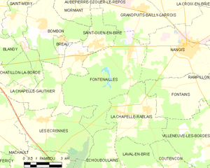
Fontenailles
- commune in Seine-et-Marne, France
- Country:
- Postal Code: 77370
- Coordinates: 48° 33' 12" N, 2° 57' 6" E
- GPS tracks (wikiloc): [Link]
- Area: 27.44 sq km
- Population: 1075
- Web site: [Link]
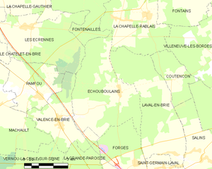
Échouboulains
- commune in Seine-et-Marne, France
- Country:
- Postal Code: 77830
- Coordinates: 48° 27' 50" N, 2° 56' 44" E
- GPS tracks (wikiloc): [Link]
- Area: 20.91 sq km
- Population: 553
- Web site: [Link]


Valence-en-Brie
- commune in Seine-et-Marne, France
- Country:
- Postal Code: 77830
- Coordinates: 48° 26' 40" N, 2° 53' 25" E
- GPS tracks (wikiloc): [Link]
- Area: 11.03 sq km
- Population: 932


Pamfou
- commune in Seine-et-Marne, France
- Country:
- Postal Code: 77830
- Coordinates: 48° 27' 41" N, 2° 52' 17" E
- GPS tracks (wikiloc): [Link]
- Area: 10.41 sq km
- Population: 957
- Web site: [Link]

La Chapelle-Gauthier
- commune in Seine-et-Marne, France
- Country:
- Postal Code: 77720
- Coordinates: 48° 32' 59" N, 2° 53' 57" E
- GPS tracks (wikiloc): [Link]
- Area: 17.36 sq km
- Population: 1460
- Web site: [Link]