Les Adrets-de-l'Estérel (Les Adrets-de-l'Estérel)

- commune in Var, France
- Country:

- Postal Code: 83600
- Coordinates: 43° 31' 32" N, 6° 48' 51" E


- GPS tracks (wikiloc): [Link]
- Area: 22.26 sq km
- Population: 2741
- Web site: http://www.mairie-adrets-esterel.fr/
- Wikipedia en: wiki(en)
- Wikipedia: wiki(fr)
- Wikidata storage: Wikidata: Q688020
- Wikipedia Commons Category: [Link]
- Freebase ID: [/m/02q6pmf]
- GeoNames ID: Alt: [3002228]
- SIREN number: [218300010]
- BnF ID: [15277828x]
- PACTOLS thesaurus ID: [pcrtEJ3PuiJs3d]
- INSEE municipality code: 83001
Shares border with regions:


Fréjus
- commune in Var, France
- Country:
- Postal Code: 83600
- Coordinates: 43° 25' 59" N, 6° 44' 8" E
- GPS tracks (wikiloc): [Link]
- Area: 102.27 sq km
- Population: 52897
- Web site: [Link]

Bagnols-en-Forêt
- commune in Var, France
 Hiking in Bagnols-en-Forêt
Bagnols-en-Forêt is a charming village located in the Var department of the Provence-Alpes-Côte d'Azur region in France. The area around Bagnols-en-Forêt offers a range of hiking opportunities that cater to different skill levels and preferences. Here are some highlights about hiking in this picturesque location:...
- Country:
- Postal Code: 83600
- Coordinates: 43° 32' 16" N, 6° 41' 54" E
- GPS tracks (wikiloc): [Link]
- Area: 42.9 sq km
- Population: 2700
- Web site: [Link]

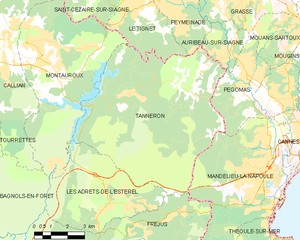
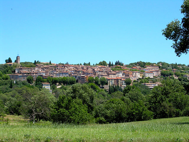
Tanneron
- commune in Var, France
Hiking in Tanneron
Tanneron is a picturesque village located in the Alpes-Maritimes department in the Provence-Alpes-Côte d'Azur region of southeastern France. Known for its stunning natural landscapes, the area offers a variety of hiking opportunities that cater to different experience levels....
- Country:
- Postal Code: 83440
- Coordinates: 43° 35' 26" N, 6° 52' 32" E
- GPS tracks (wikiloc): [Link]
- Area: 52.78 sq km
- Population: 1572


Montauroux
- commune in Var, France
Hiking in Montauroux
Montauroux, located in the Var department of the Provence-Alpes-Côte d'Azur region in southeastern France, offers a stunning backdrop for hikers with its picturesque landscapes, charming villages, and proximity to the beautiful French Riviera. Here are some highlights about hiking in Montauroux:...
- Country:
- Postal Code: 83440
- Coordinates: 43° 37' 6" N, 6° 45' 55" E
- GPS tracks (wikiloc): [Link]
- Area: 33.54 sq km
- Population: 6298