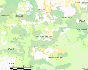
Bagnols-en-Forêt (Bagnols-en-Forêt)

- commune in Var, France
 Hiking in Bagnols-en-Forêt
Bagnols-en-Forêt is a charming village located in the Var department of the Provence-Alpes-Côte d'Azur region in France. The area around Bagnols-en-Forêt offers a range of hiking opportunities that cater to different skill levels and preferences. Here are some highlights about hiking in this picturesque location:
Trails and Nature
-
Diverse Terrain: The trails around Bagnols-en-Forêt provide a mix of landscapes, including rolling hills, oak forests, and picturesque views of the surrounding countryside. You'll also find a variety of flora and fauna endemic to the region.
-
GR Pathways: The region is crossed by several long-distance hiking trails, including sections of the GR (Grande Randonnée) trails. These well-marked paths can offer day-long hikes that lead you through stunning natural areas.
-
Local Trails: Shorter hikes can also be found in the vicinity. Local trails often connect the village to beautiful viewpoints and historical points of interest, allowing you to explore the local culture while enjoying nature.
Points of Interest
-
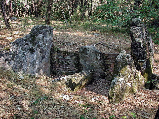
Chapelle Saint-Michel: This chapel, located on a hilltop near the village, offers stunning panoramic views and is a great destination for hikers looking to combine exercise with cultural exploration.
-
Local Wildlife: Keep an eye out for diverse wildlife, including various bird species and mammals. The regions' natural beauty often makes for great photography opportunities.
Practical Tips
-
Season: The best time to hike in Bagnols-en-Forêt is during the spring and fall, when temperatures are moderate and the scenery is particularly lush.
-
Hydration and Supplies: Always carry enough water and snacks, as some trails may have limited access to amenities.
-
Weather Conditions: Be aware of the weather conditions before heading out, as they can change quickly in this region.
-
Maps and Guides: Having a reliable map or a GPS device is advisable, especially if you are navigating less-marked trails. You can check with local tourist offices for updated trail information and recommendations.
Conclusion
Hiking in Bagnols-en-Forêt offers a unique blend of natural beauty, cultural heritage, and outdoor exercise. Whether you're a seasoned hiker or a casual walker, the trails around this quaint village provide a delightful way to experience the beauty of Provence. Enjoy your hike!
- Country:

- Postal Code: 83600
- Coordinates: 43° 32' 16" N, 6° 41' 54" E


- GPS tracks (wikiloc): [Link]
- Area: 42.9 sq km
- Population: 2700
- Web site: http://bagnolsenforet.fr
- Wikipedia en: wiki(en)
- Wikipedia: wiki(fr)
- Wikidata storage: Wikidata: Q688258
- Wikipedia Commons Category: [Link]
- Freebase ID: [/m/03qcrxs]
- GeoNames ID: Alt: [6452558]
- SIREN number: [218300085]
- BnF ID: [152778356]
- INSEE municipality code: 83008
Shares border with regions:
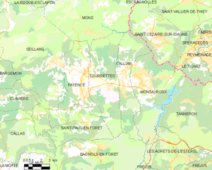
Tourrettes
- commune in Var, France
Hiking in Tourrettes
Tourrettes is a charming village located in the Var department in the Provence-Alpes-Côte d'Azur region of southeastern France. It sits on a hill overlooking the surrounding valley and is part of the beautiful landscapes that the region offers. Here are some details about hiking in and around Tourrettes:...
- Country:
- Postal Code: 83440
- Coordinates: 43° 37' 24" N, 6° 42' 8" E
- GPS tracks (wikiloc): [Link]
- AboveSeaLevel: 334 м m
- Area: 33.99 sq km
- Population: 2908


Fréjus
- commune in Var, France
- Country:
- Postal Code: 83600
- Coordinates: 43° 25' 59" N, 6° 44' 8" E
- GPS tracks (wikiloc): [Link]
- Area: 102.27 sq km
- Population: 52897
- Web site: [Link]


Roquebrune-sur-Argens
- commune in Var, France
- Country:
- Postal Code: 83520
- Coordinates: 43° 26' 36" N, 6° 38' 16" E
- GPS tracks (wikiloc): [Link]
- Area: 106.1 sq km
- Population: 13195
- Web site: [Link]

Puget-sur-Argens
- commune in Var, France
- Country:
- Postal Code: 83480
- Coordinates: 43° 27' 21" N, 6° 41' 3" E
- GPS tracks (wikiloc): [Link]
- Area: 26.9 sq km
- Population: 7528


Les Adrets-de-l'Estérel
- commune in Var, France
- Country:
- Postal Code: 83600
- Coordinates: 43° 31' 32" N, 6° 48' 51" E
- GPS tracks (wikiloc): [Link]
- Area: 22.26 sq km
- Population: 2741
- Web site: [Link]


Callian
- commune in Var, France
Hiking in Callian
Callian is a picturesque village located in the Var department of the Provence-Alpes-Côte d'Azur region in southeastern France. Known for its medieval charm and stunning views of the surrounding countryside, Callian offers a range of hiking opportunities that cater to different skill levels. Here’s what you should know about hiking in and around Callian:...
- Country:
- Postal Code: 83440
- Coordinates: 43° 37' 20" N, 6° 45' 11" E
- GPS tracks (wikiloc): [Link]
- Area: 25.42 sq km
- Population: 3238
- Web site: [Link]

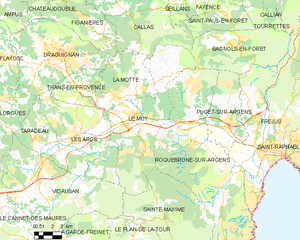
Le Muy
- commune in Var, France
Hiking in Le Muy
Le Muy, located in the Var department of the Provence-Alpes-Côte d'Azur region in France, is a fantastic spot for hiking enthusiasts. The area is characterized by its stunning natural scenery, including hills, forests, rivers, and vineyards, making it an ideal place for outdoor activities....
- Country:
- Postal Code: 83490
- Coordinates: 43° 28' 21" N, 6° 33' 59" E
- GPS tracks (wikiloc): [Link]
- Area: 66.58 sq km
- Population: 9361


Montauroux
- commune in Var, France
Hiking in Montauroux
Montauroux, located in the Var department of the Provence-Alpes-Côte d'Azur region in southeastern France, offers a stunning backdrop for hikers with its picturesque landscapes, charming villages, and proximity to the beautiful French Riviera. Here are some highlights about hiking in Montauroux:...
- Country:
- Postal Code: 83440
- Coordinates: 43° 37' 6" N, 6° 45' 55" E
- GPS tracks (wikiloc): [Link]
- Area: 33.54 sq km
- Population: 6298


Callas
- commune in Var, France
Hiking in Callas
Callas, located in the Var department of the Provence-Alpes-Côte d'Azur region in southeastern France, offers a beautiful setting for hiking enthusiasts. The village is surrounded by picturesque landscapes characterized by rolling hills, vineyards, and forests, making it an excellent destination for outdoor activities....
- Country:
- Postal Code: 83830
- Coordinates: 43° 35' 35" N, 6° 32' 18" E
- GPS tracks (wikiloc): [Link]
- Area: 49.26 sq km
- Population: 1851

Saint-Paul-en-Forêt
- commune in Var, France
Hiking in Saint-Paul-en-Forêt
Saint-Paul-en-Forêt is a picturesque village located in the Var department of Provence-Alpes-Côte d'Azur in southeastern France. It's surrounded by beautiful forests, vineyards, and hills, making it a great destination for hiking enthusiasts. Here are some key points about hiking in and around Saint-Paul-en-Forêt:...
- Country:
- Postal Code: 83440
- Coordinates: 43° 34' 2" N, 6° 41' 31" E
- GPS tracks (wikiloc): [Link]
- Area: 20.26 sq km
- Population: 1697