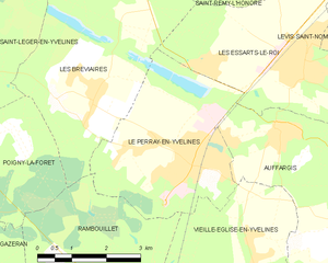
Les Essarts-le-Roi (Les Essarts-le-Roi)

- commune in Yvelines, France
- Country:

- Postal Code: 78690
- Coordinates: 48° 43' 0" N, 1° 53' 40" E


- GPS tracks (wikiloc): [Link]
- Area: 19.32 sq km
- Population: 6787
- Web site: http://www.essarts-le-roi.org
- Wikipedia en: wiki(en)
- Wikipedia: wiki(fr)
- Wikidata storage: Wikidata: Q94484
- Wikipedia Commons Category: [Link]
- Freebase ID: [/m/03c3kvh]
- Freebase ID: [/m/03c3kvh]
- GeoNames ID: Alt: [6456497]
- GeoNames ID: Alt: [6456497]
- SIREN number: [217802206]
- SIREN number: [217802206]
- BnF ID: [152759517]
- BnF ID: [152759517]
- VIAF ID: Alt: [124336394]
- VIAF ID: Alt: [124336394]
- Library of Congress authority ID: Alt: [nr92019934]
- Library of Congress authority ID: Alt: [nr92019934]
- INSEE municipality code: 78220
- INSEE municipality code: 78220
Shares border with regions:

Le Perray-en-Yvelines
- commune in Yvelines, France
- Country:
- Postal Code: 78610
- Coordinates: 48° 41' 39" N, 1° 51' 15" E
- GPS tracks (wikiloc): [Link]
- Area: 13.47 sq km
- Population: 6755
- Web site: [Link]


Senlisse
- commune in Yvelines, France
- Country:
- Postal Code: 78720
- Coordinates: 48° 41' 13" N, 1° 58' 54" E
- GPS tracks (wikiloc): [Link]
- Area: 7.9 sq km
- Population: 507
- Web site: [Link]

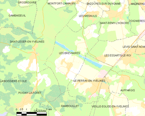
Les Bréviaires
- commune in Yvelines, France
- Country:
- Postal Code: 78610
- Coordinates: 48° 42' 28" N, 1° 48' 50" E
- GPS tracks (wikiloc): [Link]
- Area: 19.55 sq km
- Population: 1238
- Web site: [Link]

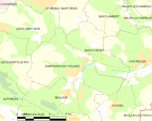
Dampierre-en-Yvelines
- commune in Yvelines, France
- Country:
- Postal Code: 78720
- Coordinates: 48° 42' 14" N, 1° 59' 3" E
- GPS tracks (wikiloc): [Link]
- AboveSeaLevel: 100 м m
- Area: 11.17 sq km
- Population: 1040
- Web site: [Link]


Coignières
- commune in Yvelines, France
- Country:
- Postal Code: 78310
- Coordinates: 48° 44' 50" N, 1° 55' 13" E
- GPS tracks (wikiloc): [Link]
- Area: 8.27 sq km
- Population: 4350
- Web site: [Link]


Auffargis
- commune in Yvelines, France
- Country:
- Postal Code: 78610
- Coordinates: 48° 42' 1" N, 1° 53' 14" E
- GPS tracks (wikiloc): [Link]
- Area: 17.14 sq km
- Population: 1997
- Web site: [Link]

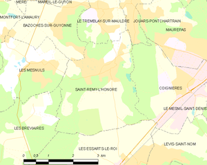
Saint-Rémy-l'Honoré
- commune in Yvelines, France
- Country:
- Postal Code: 78690
- Coordinates: 48° 45' 23" N, 1° 52' 51" E
- GPS tracks (wikiloc): [Link]
- Area: 10.15 sq km
- Population: 1497
- Web site: [Link]


Lévis-Saint-Nom
- commune in Yvelines, France
- Country:
- Postal Code: 78320
- Coordinates: 48° 43' 17" N, 1° 56' 55" E
- GPS tracks (wikiloc): [Link]
- Area: 8.25 sq km
- Population: 1630
- Web site: [Link]