Les Hermaux (Les Hermaux)

- commune in Lozère, France
- Country:

- Postal Code: 48340
- Coordinates: 44° 30' 58" N, 3° 7' 54" E


- GPS tracks (wikiloc): [Link]
- Area: 17.59 sq km
- Population: 104
- Wikipedia en: wiki(en)
- Wikipedia: wiki(fr)
- Wikidata storage: Wikidata: Q200043
- Wikipedia Commons Category: [Link]
- Freebase ID: [/m/02z0tvg]
- Freebase ID: [/m/02z0tvg]
- GeoNames ID: Alt: [6456943]
- GeoNames ID: Alt: [6456943]
- SIREN number: [214800732]
- SIREN number: [214800732]
- BnF ID: [152614792]
- BnF ID: [152614792]
- INSEE municipality code: 48073
- INSEE municipality code: 48073
Shares border with regions:


Les Salces
- commune in Lozère, France
- Country:
- Postal Code: 48100
- Coordinates: 44° 32' 2" N, 3° 9' 43" E
- GPS tracks (wikiloc): [Link]
- Area: 45.78 sq km
- Population: 101
Saint-Pierre-de-Nogaret
- commune in Lozère, France
- Country:
- Postal Code: 48340
- Coordinates: 44° 27' 41" N, 3° 8' 23" E
- GPS tracks (wikiloc): [Link]
- Area: 16.44 sq km
- Population: 179


Trélans
- commune in Lozère, France
- Country:
- Postal Code: 48340
- Coordinates: 44° 29' 59" N, 3° 5' 31" E
- GPS tracks (wikiloc): [Link]
- Area: 23.35 sq km
- Population: 95

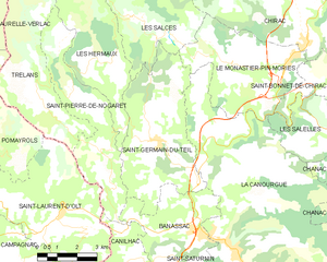
Saint-Germain-du-Teil
- commune in Lozère, France
- Country:
- Postal Code: 48340
- Coordinates: 44° 28' 41" N, 3° 10' 20" E
- GPS tracks (wikiloc): [Link]
- Area: 22.58 sq km
- Population: 863