Les Mesnuls (Les Mesnuls)

- commune in Yvelines, France
- Country:

- Postal Code: 78490
- Coordinates: 48° 45' 23" N, 1° 50' 17" E


- GPS tracks (wikiloc): [Link]
- Area: 6.49 sq km
- Population: 866
- Web site: http://www.lesmesnuls.fr
- Wikipedia en: wiki(en)
- Wikipedia: wiki(fr)
- Wikidata storage: Wikidata: Q759666
- Wikipedia Commons Category: [Link]
- Freebase ID: [/m/02r6zbz]
- Freebase ID: [/m/02r6zbz]
- GeoNames ID: Alt: [3000308]
- GeoNames ID: Alt: [3000308]
- SIREN number: [217803980]
- SIREN number: [217803980]
- BnF ID: [15276029t]
- BnF ID: [15276029t]
- VIAF ID: Alt: [172617819]
- VIAF ID: Alt: [172617819]
- Library of Congress authority ID: Alt: [n78089167]
- Library of Congress authority ID: Alt: [n78089167]
- PACTOLS thesaurus ID: [pcrtbi6LLGsRqO]
- PACTOLS thesaurus ID: [pcrtbi6LLGsRqO]
- INSEE municipality code: 78398
- INSEE municipality code: 78398
Shares border with regions:

Montfort-l'Amaury
- commune in Yvelines, France
- Country:
- Postal Code: 78490
- Coordinates: 48° 46' 38" N, 1° 48' 33" E
- GPS tracks (wikiloc): [Link]
- Area: 5.71 sq km
- Population: 2953
- Web site: [Link]


Saint-Léger-en-Yvelines
- commune in Yvelines, France
- Country:
- Postal Code: 78610
- Coordinates: 48° 43' 17" N, 1° 45' 56" E
- GPS tracks (wikiloc): [Link]
- Area: 34.52 sq km
- Population: 1388
- Web site: [Link]

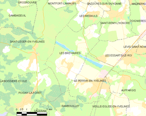
Les Bréviaires
- commune in Yvelines, France
- Country:
- Postal Code: 78610
- Coordinates: 48° 42' 28" N, 1° 48' 50" E
- GPS tracks (wikiloc): [Link]
- Area: 19.55 sq km
- Population: 1238
- Web site: [Link]


Bazoches-sur-Guyonne
- commune in Yvelines, France
- Country:
- Postal Code: 78490
- Coordinates: 48° 46' 42" N, 1° 51' 37" E
- GPS tracks (wikiloc): [Link]
- Area: 5.66 sq km
- Population: 586
- Web site: [Link]

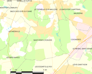
Saint-Rémy-l'Honoré
- commune in Yvelines, France
- Country:
- Postal Code: 78690
- Coordinates: 48° 45' 23" N, 1° 52' 51" E
- GPS tracks (wikiloc): [Link]
- Area: 10.15 sq km
- Population: 1497
- Web site: [Link]