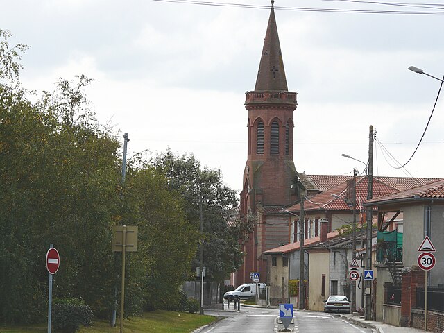
Lherm (Lherm)

- commune in Haute-Garonne, France
- Country:

- Postal Code: 31600
- Coordinates: 43° 25' 48" N, 1° 13' 19" E


- GPS tracks (wikiloc): [Link]
- AboveSeaLevel: 225 м m
- Area: 27.26 sq km
- Population: 3587
- Web site: http://www.mairie-lherm.fr/la-mairie/
- Wikipedia en: wiki(en)
- Wikipedia: wiki(fr)
- Wikidata storage: Wikidata: Q1429053
- Wikipedia Commons Category: [Link]
- Freebase ID: [/m/03nq19p]
- Freebase ID: [/m/03nq19p]
- GeoNames ID: Alt: [6616476]
- GeoNames ID: Alt: [6616476]
- SIREN number: [213102999]
- SIREN number: [213102999]
- BnF ID: [152552945]
- BnF ID: [152552945]
- INSEE municipality code: 31299
- INSEE municipality code: 31299
Shares border with regions:

Saint-Clar-de-Rivière
- commune in Haute-Garonne, France
- Country:
- Postal Code: 31600
- Coordinates: 43° 27' 58" N, 1° 12' 55" E
- GPS tracks (wikiloc): [Link]
- Area: 10.07 sq km
- Population: 1294
- Web site: [Link]

Saint-Hilaire
- commune in Haute-Garonne, France
- Country:
- Postal Code: 31410
- Coordinates: 43° 25' 22" N, 1° 16' 41" E
- GPS tracks (wikiloc): [Link]
- Area: 6.33 sq km
- Population: 1110
- Web site: [Link]


Cambernard
- commune in Haute-Garonne, France
- Country:
- Postal Code: 31470
- Coordinates: 43° 28' 29" N, 1° 10' 47" E
- GPS tracks (wikiloc): [Link]
- Area: 8.48 sq km
- Population: 468


Lavernose-Lacasse
- commune in Haute-Garonne, France
- Country:
- Postal Code: 31410
- Coordinates: 43° 23' 46" N, 1° 15' 37" E
- GPS tracks (wikiloc): [Link]
- AboveSeaLevel: 198 м m
- Area: 17.83 sq km
- Population: 2941
- Web site: [Link]

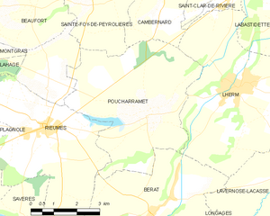
Poucharramet
- commune in Haute-Garonne, France
- Country:
- Postal Code: 31370
- Coordinates: 43° 25' 2" N, 1° 10' 26" E
- GPS tracks (wikiloc): [Link]
- Area: 22.53 sq km
- Population: 855
- Web site: [Link]

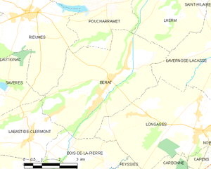
Bérat
- commune in Haute-Garonne, France
- Country:
- Postal Code: 31370
- Coordinates: 43° 22' 40" N, 1° 10' 33" E
- GPS tracks (wikiloc): [Link]
- Area: 24.46 sq km
- Population: 2951
- Web site: [Link]

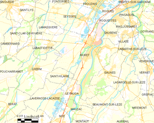
Muret
- commune in Haute-Garonne, France
- Country:
- Postal Code: 31600
- Coordinates: 43° 27' 37" N, 1° 19' 33" E
- GPS tracks (wikiloc): [Link]
- AboveSeaLevel: 169 м m
- Area: 57.84 sq km
- Population: 25264
- Web site: [Link]


Labastidette
- commune in Haute-Garonne, France
- Country:
- Postal Code: 31600
- Coordinates: 43° 27' 41" N, 1° 14' 43" E
- GPS tracks (wikiloc): [Link]
- Area: 6.27 sq km
- Population: 2443
- Web site: [Link]