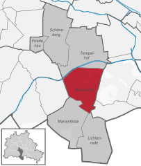
Lichtenrade (Lichtenrade)
- locality of Berlin, Germany
Lichtenrade, a district of Berlin, is more urban than it is rural, but you can still enjoy some outdoor activities in and around the area. If you're looking for hiking opportunities, here are a few suggestions:
-
Local Parks and Green Spaces: While Lichtenrade itself is primarily residential, there are several parks and green spaces nearby where you can enjoy short walks or hikes. The nearby Britzer Garten and the Dahlem Botanical Garden are good options for pleasant strolls surrounded by nature.
-
Teltow Canal: This canal offers some scenic routes for walking or hiking. You can follow trails along the canal, which provide a peaceful setting and lovely views.
-
Grunewald Forest: A bit further out, but accessible from Lichtenrade, Grunewald is one of Berlin’s largest and most beautiful forests. There are numerous trails of varying lengths where you can hike and enjoy the natural scenery.
-
Nature Reserves: Look for nearby nature reserves such as the Schönower Heide or the Teufelsberg area, which feature hiking paths and are ideal for those wishing to immerse themselves in nature.
-
Regional Hiking Trails: If you're willing to travel a bit outside of Lichtenrade, you can explore the Havel River Trail or other regional hiking paths that offer more extensive hiking opportunities.
When hiking in the area, always check the weather conditions, wear appropriate footwear, and take along sufficient water and snacks. Make sure to plan your route and let someone know your expected return time if you're venturing into less populated areas. Enjoy your hikes!
- Country:

- Postal Code: 12309; 12307; 12305
- Coordinates: 52° 24' 0" N, 13° 24' 0" E


- GPS tracks (wikiloc): [Link]
- AboveSeaLevel: 45 м m
- Area: 10.1 sq km
- Population: 49843
- Wikipedia en: wiki(en)
- Wikipedia: wiki(de)
- Wikidata storage: Wikidata: Q821101
- Wikipedia Commons Gallery: [Link]
- Wikipedia Commons Category: [Link]
- Wikipedia Commons Maps Category: [Link]
- Freebase ID: [/m/0bwksmg]
- GeoNames ID: Alt: [2878044]
- VIAF ID: Alt: [144860241]
- OSM relation ID: [157665]
- GND ID: Alt: [4099609-8]
- archINFORM location ID: [43329]
- Library of Congress authority ID: Alt: [n92117747]
- NKCR AUT ID: [ge964653]
Shares border with regions:

Mariendorf
- locality of Berlin, Germany
Mariendorf is a district in the borough of Tempelhof-Schöneberg in Berlin, Germany. While it may not be known for traditional hiking trails like you might find in more mountainous regions, there are still opportunities for outdoor activities and walks in and around the area....
- Country:

- Postal Code: 12109; 12107; 12105
- Coordinates: 52° 26' 24" N, 13° 23' 24" E


- GPS tracks (wikiloc): [Link]
- AboveSeaLevel: 49 м m
- Area: 9.38 sq km
- Population: 50956


Buckow
- locality of Berlin
Buckow is a charming district located in the borough of Neukölln in Berlin, Germany. While it may not be a traditional hiking hotspot, it does offer some lovely outdoor experiences, especially for those interested in walking, nature, and exploring the surrounding areas....
- Country:

- Postal Code: 12353; 12351; 12349
- Coordinates: 52° 25' 55" N, 13° 27' 42" E


- GPS tracks (wikiloc): [Link]
- AboveSeaLevel: 44 м m
- Area: 6.35 sq km
- Population: 39184


Marienfelde
- locality of Berlin, Germany
Marienfelde is a district located in the southwestern part of Berlin, Germany. While it may not be a traditional hiking destination with extensive trails like you might find in national parks, there are still some opportunities for walking and exploring the natural surroundings in and around the area....
- Country:

- Postal Code: 12249; 12279; 12277
- Coordinates: 52° 25' 0" N, 13° 22' 0" E


- GPS tracks (wikiloc): [Link]
- AboveSeaLevel: 44 м m
- Area: 9.15 sq km
- Population: 31372

