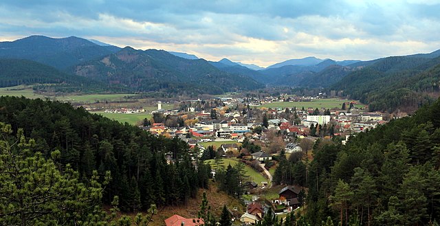
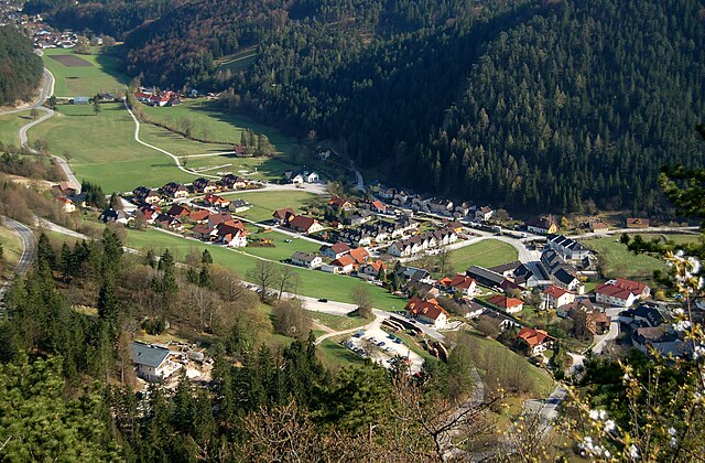
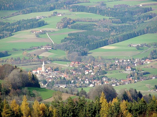
Wiener Neustadt-Land District (Bezirk Wiener Neustadt-Land)

- district of Austria
 Hiking in Wiener Neustadt-Land District
Wiener Neustadt-Land District, located in the state of Lower Austria, offers a range of excellent hiking opportunities that cater to various skill levels. The region features beautiful landscapes, including rolling hills, forests, and meadows, providing a scenic backdrop for outdoor enthusiasts.
Highlights of Hiking in Wiener Neustadt-Land:
-
Diverse Trails: The district boasts a variety of trails ranging from easy walks suitable for families to more challenging hikes for experienced trekkers. You can find well-marked routes that lead through picturesque villages and natural parks.
-
Natural Attractions: Take in the stunning views of the surrounding countryside, including prominent landmarks such as the Schneeberg and Rax mountains. The region's rich biodiversity offers opportunities for bird watching and observing local flora and fauna.
-
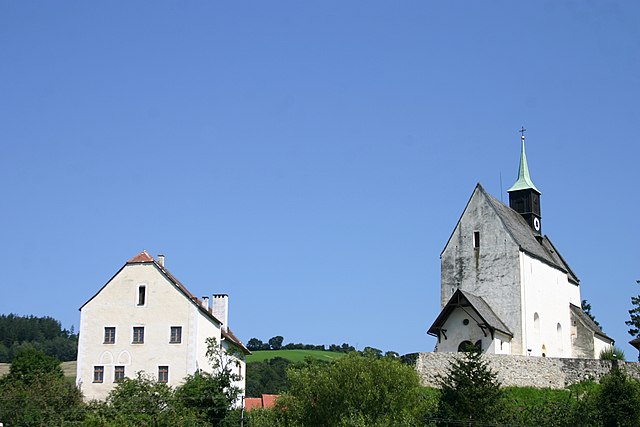
Cultural Hikes: Many trails connect historical sites, such as castles and churches. Hiking in this area allows you to blend nature with cultural exploration.
-
Local Amenities: Many hiking routes have nearby amenities, including traditional Austrian inns (Gasthäuser) where you can enjoy local cuisine and refreshments after a long hike.
-
Seasonal Hiking: Each season brings its own charm to the landscape. Spring and summer are ideal for wildflower hikes, while fall offers stunning autumn colors. Winter hiking is also popular, with trails suitable for snowshoeing and enjoying the crisp, cold air.
-
Guided Tours: For those new to the area, consider joining guided hikes offered by local organizations. This can enhance your experience by providing insights into the natural and cultural history of the region.
Tips for Hiking in Wiener Neustadt-Land:
- Plan Ahead: Research trails to choose one that suits your fitness level and experience.
- Check Weather Conditions: Weather can change quickly in the mountains, so always check forecasts and prepare accordingly.
- Pack Essentials: Bring plenty of water, snacks, a map (or a GPS device), appropriate clothing, and a first aid kit.
- Respect Nature: Stay on marked trails, follow local guidelines, and pack out any trash to help preserve the natural beauty of the area.
Overall, Wiener Neustadt-Land District is a fantastic destination for hiking enthusiasts and those looking to enjoy the great outdoors in a beautiful setting.
- Country:

- Capital: Wiener Neustadt
- Licence Plate Code: WB
- Coordinates: 47° 37' 21" N, 16° 20' 27" E


- GPS tracks (wikiloc): [Link]
- AboveSeaLevel: 445 м m
- Area: 969.72 sq km
- Web site: http://www.noel.gv.at/Bezirke/BH-Wiener-Neustadt.html
- Wikipedia en: wiki(en)
- Wikipedia: wiki(de)
- Wikidata storage: Wikidata: Q694413
- Wikipedia Commons Category: [Link]
- Wikipedia Commons Maps Category: [Link]
- Freebase ID: [/m/0flbxc]
- GeoNames ID: Alt: [2761352]
- VIAF ID: Alt: [243836689]
- GND ID: Alt: [4331672-4]
- archINFORM location ID: [14645]
Includes regions:

Zillingdorf
- municipality in Austria
Hiking in Zillingdorf
Zillingdorf, located in Austria, offers a variety of hiking opportunities that cater to different skill levels. The region is characterized by its picturesque landscapes, rolling hills, and beautiful views, making it a great destination for nature enthusiasts and hikers....
- Country:
- Local Dialing Code: 02622
- Licence Plate Code: WB
- Coordinates: 47° 51' 0" N, 16° 20' 0" E
- GPS tracks (wikiloc): [Link]
- AboveSeaLevel: 241 м m
- Area: 15.34 sq km
- Population: 2030
- Web site: [Link]

Kirchschlag in der Buckligen Welt
- municipality in Austria
Hiking in Kirchschlag in der Buckligen Welt
Kirchschlag in der Buckligen Welt is a beautiful area located in Austria, known for its picturesque landscapes, rolling hills, and extensive hiking opportunities. This region is particularly appealing to outdoor enthusiasts and nature lovers....
- Country:
- Local Dialing Code: 02646
- Licence Plate Code: WB
- Coordinates: 47° 30' 0" N, 16° 17' 0" E
- GPS tracks (wikiloc): [Link]
- AboveSeaLevel: 417 м m
- Area: 57.97 sq km
- Population: 2889
- Web site: [Link]

Lichtenwörth
- municipality in Austria
Hiking in Lichtenwörth
Lichtenwörth is a charming municipality located in Austria, not far from the city of Wiener Neustadt. The surrounding landscape offers a variety of hiking trails suitable for different skill levels, making it a great destination for both beginners and experienced hikers....
- Country:
- Local Dialing Code: 02622
- Licence Plate Code: WB
- Coordinates: 47° 49' 55" N, 16° 17' 44" E
- GPS tracks (wikiloc): [Link]
- AboveSeaLevel: 254 м m
- Area: 22.91 sq km
- Population: 2727
- Web site: [Link]

Sollenau
- municipality in Austria
Hiking in Sollenau
Sollenau, located in the picturesque Lower Austria region, offers a variety of hiking opportunities suitable for different skill levels. While it's a smaller town, its surrounding landscapes feature gentle hills, lush forests, and beautiful farmland, providing a serene backdrop for outdoor activities....
- Country:
- Local Dialing Code: 02628
- Licence Plate Code: WB
- Coordinates: 47° 54' 0" N, 16° 15' 0" E
- GPS tracks (wikiloc): [Link]
- AboveSeaLevel: 277 м m
- Area: 10.67 sq km
- Population: 5038
- Web site: [Link]


Waidmannsfeld
- municipality in Austria
Hiking in Waidmannsfeld
Waidmannsfeld is a picturesque area located in Austria, known for its natural beauty and numerous hiking opportunities. Here’s an overview of what you might expect when hiking in Waidmannsfeld:...
- Country:
- Local Dialing Code: 02632
- Licence Plate Code: WB
- Coordinates: 47° 52' 0" N, 15° 58' 0" E
- GPS tracks (wikiloc): [Link]
- AboveSeaLevel: 495 м m
- Area: 21.39 sq km
- Population: 1515
- Web site: [Link]

Schwarzenbach, Lower Austria
- municipality in Austria
Hiking in Schwarzenbach, Lower Austria
Schwarzenbach, located in Lower Austria, is known for its beautiful landscapes and picturesque trails, making it a fantastic destination for hiking enthusiasts. Here are some key aspects to consider if you're planning a hiking trip to this area:...
- Country:
- Postal Code: 2803; 2802
- Local Dialing Code: 02645
- Licence Plate Code: WB
- Coordinates: 47° 38' 0" N, 16° 21' 0" E
- GPS tracks (wikiloc): [Link]
- AboveSeaLevel: 383 м m
- Area: 22.31 sq km
- Population: 941
- Web site: [Link]

Ebenfurth
- municipality in Austria
Hiking in Ebenfurth
Ebenfurth is a small town located in the state of Lower Austria, close to Vienna. While it may not be as widely known for hiking as some of the larger national parks or mountainous regions, there are still opportunities for outdoor enthusiasts to enjoy nature in and around this area....
- Country:
- Local Dialing Code: 02624
- Licence Plate Code: WB
- Coordinates: 47° 52' 33" N, 16° 22' 25" E
- GPS tracks (wikiloc): [Link]
- AboveSeaLevel: 230 м m
- Area: 23.58 sq km
- Population: 3170
- Web site: [Link]

Katzelsdorf
- municipality in Austria
Hiking in Katzelsdorf
Katzelsdorf, located in Austria's Lower Austria region, offers a beautiful setting for hiking enthusiasts. The area is known for its picturesque landscapes, rolling hills, and access to various trails suitable for different skill levels....
- Country:
- Local Dialing Code: 02622
- Licence Plate Code: WB
- Coordinates: 47° 46' 44" N, 16° 16' 25" E
- GPS tracks (wikiloc): [Link]
- AboveSeaLevel: 273 м m
- Area: 16.25 sq km
- Population: 3257
- Web site: [Link]

Gutenstein
- municipality in Austria
Hiking in Gutenstein
Gutenstein, located in the picturesque region of Lower Austria, is a great destination for hiking enthusiasts. The area is characterized by its stunning natural landscapes, rolling hills, dense forests, and diverse flora and fauna, making it a perfect spot for outdoor activities....
- Country:
- Local Dialing Code: 02634
- Licence Plate Code: WB
- Coordinates: 47° 52' 0" N, 15° 53' 0" E
- GPS tracks (wikiloc): [Link]
- AboveSeaLevel: 481 м m
- Area: 104.2 sq km
- Population: 1268
- Web site: [Link]
Felixdorf
- municipality in Austria
Hiking in Felixdorf
Felixdorf, located in Lower Austria, is a charming area that provides a variety of hiking opportunities, appealing to both novice and seasoned hikers. Nestled near the foothills of the Vienna Woods, this region boasts beautiful landscapes, forests, and scenic trails that are perfect for outdoor enthusiasts....
- Country:
- Postal Code: 2603
- Local Dialing Code: 02628
- Licence Plate Code: WB
- Coordinates: 47° 53' 0" N, 16° 14' 0" E
- GPS tracks (wikiloc): [Link]
- AboveSeaLevel: 282 м m
- Area: 2.54 sq km
- Population: 4292
- Web site: [Link]

Lanzenkirchen
- municipality in Austria
Hiking in Lanzenkirchen
Lanzenkirchen is a charming village located in the Lower Austria region of Austria, nestled at the foothills of the Alps. It's an excellent destination for hiking enthusiasts, offering a variety of trails that cater to different skill levels....
- Country:
- Local Dialing Code: 02627
- Licence Plate Code: WB
- Coordinates: 47° 44' 50" N, 16° 14' 50" E
- GPS tracks (wikiloc): [Link]
- AboveSeaLevel: 298 м m
- Area: 29.80 sq km
- Population: 3983
- Web site: [Link]

Bad Fischau-Brunn
- municipality in Austria
Hiking in Bad Fischau-Brunn
Bad Fischau-Brunn, located in Austria, offers a variety of hiking opportunities that cater to both novice and experienced hikers. Nestled near the picturesque landscapes of the Wienerwald (Vienna Woods) and close to the northern foothills of the Alps, this area is characterized by its rolling hills, lush forests, and scenic views....
- Country:
- Postal Code: 2721
- Local Dialing Code: 02639
- Licence Plate Code: WB
- Coordinates: 47° 50' 0" N, 16° 10' 0" E
- GPS tracks (wikiloc): [Link]
- AboveSeaLevel: 288 м m
- Area: 20.59 sq km
- Population: 3440
- Web site: [Link]
Walpersbach
- municipality in Austria
Hiking in Walpersbach
Walpersbach is a charming area located in Austria, known for its picturesque landscapes and scenic hiking trails. The region offers a variety of hiking opportunities suitable for all skill levels, ranging from easy walks to more challenging treks. Here are some highlights and tips for hiking in Walpersbach:...
- Country:
- Local Dialing Code: 02627
- Licence Plate Code: WB
- Coordinates: 47° 43' 0" N, 16° 14' 0" E
- GPS tracks (wikiloc): [Link]
- AboveSeaLevel: 317 м m
- Area: 16.46 sq km
- Population: 1125
- Web site: [Link]
Winzendorf-Muthmannsdorf
- municipality in Austria
Hiking in Winzendorf-Muthmannsdorf
Winzendorf-Muthmannsdorf is a charming area in Austria that offers beautiful hiking opportunities, nestled in the scenic landscapes of the Lower Austria region. Known for its picturesque views of the surrounding mountains and lush greenery, this area is perfect for both novice and experienced hikers....
- Country:
- Local Dialing Code: 02638
- Licence Plate Code: WB
- Coordinates: 47° 48' 0" N, 16° 7' 0" E
- GPS tracks (wikiloc): [Link]
- AboveSeaLevel: 327 м m
- Area: 16.16 sq km
- Population: 1877
- Web site: [Link]
Pernitz
- municipality in Austria
Hiking in Pernitz
Pernitz is a charming village located in the Lower Austria region of Austria, surrounded by the picturesque landscapes of the Wienerwald (Vienna Woods). Hiking in Pernitz offers hikers a fantastic opportunity to explore stunning natural scenery, rich biodiversity, and historical sites, making it an excellent destination for outdoor enthusiasts....
- Country:
- Local Dialing Code: 02632
- Licence Plate Code: WB
- Coordinates: 47° 54' 0" N, 15° 58' 0" E
- GPS tracks (wikiloc): [Link]
- AboveSeaLevel: 430 м m
- Area: 16.59 sq km
- Population: 2473
- Web site: [Link]

Hohe Wand
- municipality in Austria
Hiking in Hohe Wand
Hohe Wand is a stunning mountain range located in Austria, specifically in the eastern part of the country near the town of Markt Piesting. It is part of the Northern Limestone Alps and is renowned for its striking cliffs, diverse wildlife, and a variety of hiking trails suitable for all levels of experience. Here’s a guide to what you can expect when hiking in Hohe Wand:...
- Country:
- Postal Code: 2722–2724
- Local Dialing Code: 02638
- Licence Plate Code: WB
- Coordinates: 47° 50' 0" N, 16° 5' 0" E
- GPS tracks (wikiloc): [Link]
- AboveSeaLevel: 450 м m
- Area: 24.61 sq km
- Population: 1428
- Web site: [Link]
Markt Piesting
- municipality in Austria
Hiking in Markt Piesting
Markt Piesting is a charming area located in Lower Austria, known for its scenic landscapes and opportunities for outdoor activities, including hiking. The region boasts a variety of trails suitable for different skill levels, making it an excellent destination for both beginners and experienced hikers....
- Country:
- Local Dialing Code: 02633
- Licence Plate Code: WB
- Coordinates: 47° 52' 22" N, 16° 7' 44" E
- GPS tracks (wikiloc): [Link]
- AboveSeaLevel: 349 м m
- Area: 18.17 sq km
- Population: 3007
- Web site: [Link]
Waldegg, Lower Austria
- municipality in Austria
Hiking in Waldegg, Lower Austria
Waldegg, located in Lower Austria, is a picturesque area ideal for hiking enthusiasts. Nestled in the foothills of the Alps, it offers a variety of trails that cater to different skill levels, making it a great destination for both beginners and experienced hikers. Here are some highlights of hiking in Waldegg:...
- Country:
- Local Dialing Code: 02633
- Licence Plate Code: WB
- Coordinates: 47° 52' 0" N, 16° 2' 0" E
- GPS tracks (wikiloc): [Link]
- AboveSeaLevel: 402 м m
- Area: 35.69 sq km
- Population: 2048
- Web site: [Link]

Muggendorf
- municipality in Austria
Hiking in Muggendorf
Muggendorf, located in the scenic region of Lower Austria, is known for its beautiful landscapes and rich natural diversity, making it a fantastic destination for hikers. Situated near the Vienna Woods, the area offers a variety of trails suitable for different skill levels. Here are some highlights of hiking in Muggendorf:...
- Country:
- Postal Code: 2763
- Local Dialing Code: 02632
- Licence Plate Code: WB
- Coordinates: 47° 54' 0" N, 15° 56' 0" E
- GPS tracks (wikiloc): [Link]
- AboveSeaLevel: 450 м m
- Area: 50.93 sq km
- Population: 528
- Web site: [Link]
Wöllersdorf-Steinabrückl
- municipality in Austria
Hiking in Wöllersdorf-Steinabrückl
Wöllersdorf-Steinabrückl, located in Austria, offers some beautiful hiking opportunities, especially for those who appreciate natural landscapes and a touch of local history. This area is characterized by its rolling hills, lush forests, and picturesque villages....
- Country:
- Licence Plate Code: WB
- Coordinates: 47° 52' 0" N, 16° 10' 0" E
- GPS tracks (wikiloc): [Link]
- AboveSeaLevel: 315 м m
- Area: 14.53 sq km
- Population: 4473
- Web site: [Link]

Weikersdorf am Steinfelde
- municipality in Austria
Hiking in Weikersdorf am Steinfelde
Weikersdorf am Steinfelde is a charming village located in Austria, nestled within the scenic landscapes of Lower Austria. This area offers a variety of hiking opportunities that cater to different experience levels, with trails showcasing beautiful natural surroundings, rolling hills, and lush forests....
- Country:
- Local Dialing Code: 02638
- Licence Plate Code: WB
- Coordinates: 47° 48' 20" N, 16° 8' 35" E
- GPS tracks (wikiloc): [Link]
- AboveSeaLevel: 307 м m
- Area: 14.22 sq km
- Population: 1066
- Web site: [Link]
Bromberg, Lower Austria
- municipality in Austria
Hiking in Bromberg, Lower Austria
Bromberg, a small municipality in Lower Austria, is known for its scenic beauty and tranquility, making it a lovely destination for hiking enthusiasts. Located near the picturesque landscapes of the region, hiking in this area allows you to experience both the natural environment and cultural heritage of Austria....
- Country:
- Local Dialing Code: 02629
- Licence Plate Code: WB
- Coordinates: 47° 40' 0" N, 16° 11' 0" E
- GPS tracks (wikiloc): [Link]
- AboveSeaLevel: 487 м m
- Area: 30.89 sq km
- Population: 1232
- Web site: [Link]

Matzendorf-Hölles
- municipality in Austria
Hiking in Matzendorf-Hölles
Matzendorf-Hölles is located in the beautiful state of Lower Austria, Austria. This area is known for its picturesque landscapes and offers various outdoor activities, including hiking. Here are some important points to consider when hiking in and around Matzendorf-Hölles:...
- Country:
- Local Dialing Code: 02628
- Licence Plate Code: WB
- Coordinates: 47° 53' 0" N, 16° 13' 0" E
- GPS tracks (wikiloc): [Link]
- AboveSeaLevel: 287 м m
- Area: 14.07 sq km
- Population: 2040
- Web site: [Link]
Hollenthon
- municipality in Austria
Hiking in Hollenthon
Hollenthon, located in the beautiful Lower Austria region, is a charming destination for hikers looking to explore the scenic landscape of the area. Here are some key points about hiking in Hollenthon:...
- Country:
- Local Dialing Code: 02645
- Licence Plate Code: WB
- Coordinates: 47° 35' 24" N, 16° 15' 33" E
- GPS tracks (wikiloc): [Link]
- AboveSeaLevel: 661 м m
- Area: 23.79 sq km
- Population: 1018
- Web site: [Link]

Theresienfeld
- municipality in Austria
Hiking in Theresienfeld
Theresienfeld, located in Lower Austria, is a lesser-known destination for hiking enthusiasts, but it offers a charming landscape and opportunities for exploration. The area is characterized by rolling hills, lush forests, and agricultural fields, making it suitable for various hiking routes....
- Country:
- Postal Code: 2604
- Local Dialing Code: 02622
- Licence Plate Code: WB
- Coordinates: 47° 51' 0" N, 16° 13' 0" E
- GPS tracks (wikiloc): [Link]
- AboveSeaLevel: 282 м m
- Area: 11.42 sq km
- Population: 3485
- Web site: [Link]

Wiesmath
- municipality in Austria
Hiking in Wiesmath
Wiesmath, a charming community located in Austria’s Lower Austria region, offers a variety of hiking opportunities for outdoor enthusiasts. Surrounded by picturesque landscapes, lush forests, and rolling hills, hikers can enjoy both serene nature walks and more challenging trails. Here are some details to consider if you’re planning to hike in and around Wiesmath:...
- Country:
- Postal Code: 2811
- Local Dialing Code: 02645
- Licence Plate Code: WB
- Coordinates: 47° 37' 0" N, 16° 17' 0" E
- GPS tracks (wikiloc): [Link]
- AboveSeaLevel: 695 м m
- Area: 38.48 sq km
- Population: 1509
- Web site: [Link]

Eggendorf
- municipality in Austria
Hiking in Eggendorf
Eggendorf, located in Lower Austria, is surrounded by picturesque landscapes that offer a range of hiking opportunities. The region is characterized by its rolling hills, lush forests, and scenic views, making it an excellent destination for outdoor enthusiasts....
- Country:
- Local Dialing Code: 02622
- Licence Plate Code: WB
- Coordinates: 47° 51' 24" N, 16° 19' 40" E
- GPS tracks (wikiloc): [Link]
- AboveSeaLevel: 241 м m
- Area: 20.59 sq km
- Population: 4794
- Web site: [Link]


Hochwolkersdorf
- municipality in Austria
Hiking in Hochwolkersdorf
Hochwolkersdorf is a charming area located in Lower Austria, known for its picturesque landscapes and natural beauty. The region offers several hiking trails that cater to various skill levels, making it a great destination for both casual walkers and experienced hikers....
- Country:
- Postal Code: 2802
- Local Dialing Code: 02645
- Licence Plate Code: WB
- Coordinates: 47° 39' 37" N, 16° 16' 56" E
- GPS tracks (wikiloc): [Link]
- AboveSeaLevel: 630 м m
- Area: 23.54 sq km
- Population: 1004
- Web site: [Link]

Lichtenegg
- municipality in Austria
Hiking in Lichtenegg
Lichtenegg, located in Austria, is a beautiful area that offers a variety of hiking trails suitable for different skill levels. Here are some key points to consider if you're planning a hiking trip in Lichtenegg:...
- Country:
- Local Dialing Code: 02643
- Licence Plate Code: WB
- Coordinates: 47° 36' 0" N, 16° 12' 0" E
- GPS tracks (wikiloc): [Link]
- AboveSeaLevel: 770 м m
- Area: 35.4 sq km
- Population: 1034
- Web site: [Link]
Bad Schönau
- municipality in Austria
Hiking in Bad Schönau
Bad Schönau is a charming spa town located in the foothills of the eastern Alps in Austria, offering beautiful landscapes and a variety of hiking trails. The region is known for its lush forests, rolling hills, and scenic views, making it an excellent destination for outdoor enthusiasts. Here are some highlights for hiking in Bad Schönau:...
- Country:
- Postal Code: 2853
- Local Dialing Code: 02646
- Licence Plate Code: WB
- Coordinates: 47° 29' 0" N, 16° 14' 0" E
- GPS tracks (wikiloc): [Link]
- AboveSeaLevel: 490 м m
- Area: 13.58 sq km
- Population: 721
- Web site: [Link]
Hochneukirchen-Gschaidt
- municipality in Austria
Hiking in Hochneukirchen-Gschaidt
Hochneukirchen-Gschaidt, located in Lower Austria, offers a beautiful setting for hiking enthusiasts with its picturesque landscapes, rolling hills, and diverse natural environments. Here are some highlights and tips for hiking in this area:...
- Country:
- Postal Code: 2852
- Local Dialing Code: 02648
- Licence Plate Code: WB
- Coordinates: 47° 27' 0" N, 16° 12' 0" E
- GPS tracks (wikiloc): [Link]
- AboveSeaLevel: 769 м m
- Area: 35.13 sq km
- Population: 1633
- Web site: [Link]

Miesenbach, Lower Austria
- municipality in Austria
Hiking in Miesenbach, Lower Austria
Miesenbach, a small village located in Lower Austria, is surrounded by beautiful landscapes and offers a variety of hiking opportunities that appeal to outdoor enthusiasts. Here are some highlights of hiking in the Miesenbach area:...
- Country:
- Postal Code: 2761
- Local Dialing Code: 02632
- Licence Plate Code: WB
- Coordinates: 47° 50' 0" N, 15° 59' 0" E
- GPS tracks (wikiloc): [Link]
- AboveSeaLevel: 470 м m
- Area: 34.13 sq km
- Population: 703
- Web site: [Link]

Bad Erlach
- municipality in Austria
Hiking in Bad Erlach
Bad Erlach, located in Austria, is an excellent destination for hiking enthusiasts, offering a variety of trails and beautiful landscapes. This charming town in Lower Austria is surrounded by the gentle hills of the Pitten Valley and the rolling countryside, making it ideal for both leisurely walks and more challenging hikes....
- Country:
- Local Dialing Code: 02627
- Licence Plate Code: WB
- Coordinates: 46° 59' 0" N, 15° 59' 0" E
- GPS tracks (wikiloc): [Link]
- AboveSeaLevel: 312 м m
- Area: 9.15 sq km
- Population: 3084
- Web site: [Link]
Krumbach
- municipality in Lower Austria, Austria
Hiking in Krumbach
Krumbach, located in Lower Austria, offers a picturesque setting for hiking enthusiasts. The region is characterized by its rolling hills, lush forests, and open spaces, making it ideal for various types of hikes, from leisurely walks to more challenging trails....
- Country:
- Local Dialing Code: 02647
- Licence Plate Code: WB
- Coordinates: 47° 31' 27" N, 16° 11' 31" E
- GPS tracks (wikiloc): [Link]
- AboveSeaLevel: 533 м m
- Area: 43.91 sq km
- Population: 2316
- Web site: [Link]

Rohr im Gebirge
- municipality in Austria
Hiking in Rohr im Gebirge
Rohr im Gebirge is a picturesque area located in Lower Austria, known for its scenic landscapes and charming natural surroundings. While it may not be as widely recognized as some of Austria's larger hiking destinations, it offers a range of trails suitable for various skill levels amidst beautiful countryside....
- Country:
- Postal Code: 2663
- Local Dialing Code: 02667
- Licence Plate Code: WB
- Coordinates: 47° 52' 0" N, 15° 43' 0" E
- GPS tracks (wikiloc): [Link]
- AboveSeaLevel: 683 м m
- Area: 80.6 sq km
- Population: 476
- Web site: [Link]