Lieucourt (Lieucourt)

- commune in Haute-Saône, France
- Country:

- Postal Code: 70140
- Coordinates: 47° 21' 4" N, 5° 37' 25" E


- GPS tracks (wikiloc): [Link]
- Area: 4.8 sq km
- Population: 80
- Wikipedia en: wiki(en)
- Wikipedia: wiki(fr)
- Wikidata storage: Wikidata: Q254268
- Wikipedia Commons Category: [Link]
- Freebase ID: [/m/03ntfgk]
- GeoNames ID: Alt: [6441985]
- SIREN number: [217003029]
- BnF ID: [15272694z]
- INSEE municipality code: 70302
Shares border with regions:

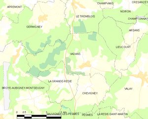
Vadans, Haute-Saône
- commune in Haute-Saône, France
- Country:
- Postal Code: 70140
- Coordinates: 47° 20' 53" N, 5° 35' 13" E
- GPS tracks (wikiloc): [Link]
- AboveSeaLevel: 212 м m
- Area: 12.95 sq km
- Population: 138


Arsans
- commune in Haute-Saône, France
- Country:
- Postal Code: 70100
- Coordinates: 47° 21' 55" N, 5° 37' 41" E
- GPS tracks (wikiloc): [Link]
- Area: 2.48 sq km
- Population: 50


Noiron
- commune in Haute-Saône, France
- Country:
- Postal Code: 70100
- Coordinates: 47° 23' 2" N, 5° 37' 44" E
- GPS tracks (wikiloc): [Link]
- Area: 5.58 sq km
- Population: 56


Valay
- commune in Haute-Saône, France
- Country:
- Postal Code: 70140
- Coordinates: 47° 20' 18" N, 5° 38' 21" E
- GPS tracks (wikiloc): [Link]
- Area: 17.4 sq km
- Population: 683
Le Tremblois
- commune in Haute-Saône, France
- Country:
- Postal Code: 70100
- Coordinates: 47° 23' 2" N, 5° 34' 39" E
- GPS tracks (wikiloc): [Link]
- Area: 5.49 sq km
- Population: 185