Lignac (Lignac)

- commune in Indre, France
- Country:

- Postal Code: 36370
- Coordinates: 46° 27' 58" N, 1° 13' 6" E


- GPS tracks (wikiloc): [Link]
- Area: 67.03 sq km
- Population: 487
- Web site: http://www.lignac.fr/
- Wikipedia en: wiki(en)
- Wikipedia: wiki(fr)
- Wikidata storage: Wikidata: Q1137597
- Wikipedia Commons Category: [Link]
- Freebase ID: [/m/03nvbdk]
- GeoNames ID: Alt: [2998414]
- SIREN number: [213600943]
- BnF ID: [152573989]
- VIAF ID: Alt: [247425753]
- INSEE municipality code: 36094
Shares border with regions:


Bélâbre
- commune in Indre, France
- Country:
- Postal Code: 36370
- Coordinates: 46° 33' 5" N, 1° 9' 29" E
- GPS tracks (wikiloc): [Link]
- Area: 40.14 sq km
- Population: 980
- Web site: [Link]

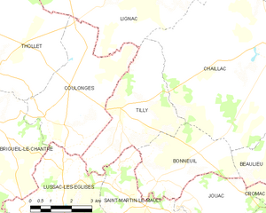
Tilly
- commune in Indre, France
- Country:
- Postal Code: 36310
- Coordinates: 46° 24' 23" N, 1° 12' 7" E
- GPS tracks (wikiloc): [Link]
- Area: 14.77 sq km
- Population: 136


Prissac
- commune in Indre, France
- Country:
- Postal Code: 36370
- Coordinates: 46° 30' 37" N, 1° 18' 28" E
- GPS tracks (wikiloc): [Link]
- Area: 62.83 sq km
- Population: 657


Dunet
- commune in Indre, France
- Country:
- Postal Code: 36310
- Coordinates: 46° 28' 5" N, 1° 17' 29" E
- GPS tracks (wikiloc): [Link]
- Area: 9.24 sq km
- Population: 103

Liglet
- commune in Vienne, France
- Country:
- Postal Code: 86290
- Coordinates: 46° 30' 34" N, 1° 5' 4" E
- GPS tracks (wikiloc): [Link]
- Area: 52.53 sq km
- Population: 319
Thollet
- commune in Vienne, France
- Country:
- Postal Code: 86290
- Coordinates: 46° 25' 15" N, 1° 7' 25" E
- GPS tracks (wikiloc): [Link]
- Area: 29.92 sq km
- Population: 160


Coulonges
- commune in Vienne, France
- Country:
- Postal Code: 86290
- Coordinates: 46° 24' 9" N, 1° 9' 16" E
- GPS tracks (wikiloc): [Link]
- AboveSeaLevel: 196 м m
- Area: 18.35 sq km
- Population: 244

Chaillac
- commune in Indre, France
- Country:
- Postal Code: 36310
- Coordinates: 46° 26' 4" N, 1° 17' 56" E
- GPS tracks (wikiloc): [Link]
- Area: 59.79 sq km
- Population: 1076


Chalais
- commune in Indre, France
- Country:
- Postal Code: 36370
- Coordinates: 46° 32' 11" N, 1° 11' 49" E
- GPS tracks (wikiloc): [Link]
- Area: 39.65 sq km
- Population: 145