Chaillac (Chaillac)

- commune in Indre, France
- Country:

- Postal Code: 36310
- Coordinates: 46° 26' 4" N, 1° 17' 56" E


- GPS tracks (wikiloc): [Link]
- Area: 59.79 sq km
- Population: 1076
- Wikipedia en: wiki(en)
- Wikipedia: wiki(fr)
- Wikidata storage: Wikidata: Q624059
- Wikipedia Commons Category: [Link]
- Freebase ID: [/m/03nvb2l]
- GeoNames ID: Alt: [6448586]
- SIREN number: [213600356]
- BnF ID: [15257339s]
- INSEE municipality code: 36035
Shares border with regions:

Cromac
- commune in Haute-Vienne, France
- Country:
- Postal Code: 87160
- Coordinates: 46° 20' 32" N, 1° 18' 0" E
- GPS tracks (wikiloc): [Link]
- Area: 24.15 sq km
- Population: 255

La Châtre-Langlin
- commune in Indre, France
- Country:
- Postal Code: 36170
- Coordinates: 46° 24' 30" N, 1° 23' 21" E
- GPS tracks (wikiloc): [Link]
- Area: 27.4 sq km
- Population: 548


Beaulieu
- commune in Indre, France
- Country:
- Postal Code: 36310
- Coordinates: 46° 23' 12" N, 1° 18' 26" E
- GPS tracks (wikiloc): [Link]
- Area: 7.48 sq km
- Population: 62


Bonneuil
- commune in Indre, France
- Country:
- Postal Code: 36310
- Coordinates: 46° 22' 27" N, 1° 13' 34" E
- GPS tracks (wikiloc): [Link]
- Area: 11.41 sq km
- Population: 89

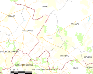
Tilly
- commune in Indre, France
- Country:
- Postal Code: 36310
- Coordinates: 46° 24' 23" N, 1° 12' 7" E
- GPS tracks (wikiloc): [Link]
- Area: 14.77 sq km
- Population: 136


Sacierges-Saint-Martin
- commune in Indre, France
- Country:
- Postal Code: 36170
- Coordinates: 46° 29' 40" N, 1° 21' 54" E
- GPS tracks (wikiloc): [Link]
- Area: 31.17 sq km
- Population: 316
- Web site: [Link]


Lignac
- commune in Indre, France
- Country:
- Postal Code: 36370
- Coordinates: 46° 27' 58" N, 1° 13' 6" E
- GPS tracks (wikiloc): [Link]
- Area: 67.03 sq km
- Population: 487
- Web site: [Link]


Dunet
- commune in Indre, France
- Country:
- Postal Code: 36310
- Coordinates: 46° 28' 5" N, 1° 17' 29" E
- GPS tracks (wikiloc): [Link]
- Area: 9.24 sq km
- Population: 103

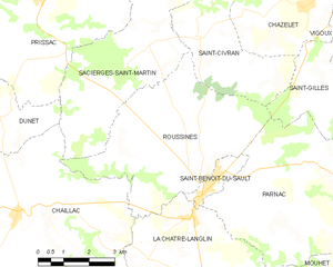
Roussines
- commune in Indre, France
- Country:
- Postal Code: 36170
- Coordinates: 46° 28' 7" N, 1° 23' 22" E
- GPS tracks (wikiloc): [Link]
- Area: 22.98 sq km
- Population: 354