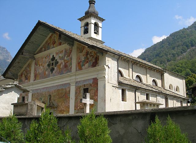
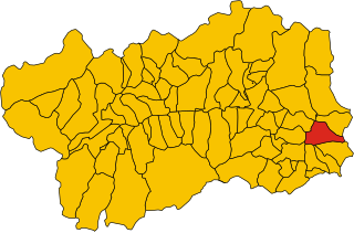
Lillianes (Lillianes)
.svg)
- Italian comune
 Hiking in Lillianes
Lillianes is a small village located in the Aosta Valley region of northern Italy, nestled in a picturesque setting at the foot of the Alps. It’s an excellent starting point for various hiking adventures, offering stunning views, rich flora and fauna, and a chance to experience the natural beauty of the region.
Hiking Opportunities in Lillianes:
-
Scenic Trails: The area offers a variety of hiking trails ranging from easy walks suitable for families to more challenging treks for experienced hikers. The trails often feature breathtaking panoramas of the mountains and valleys.
-
Nature and Wildlife: The surrounding nature is diverse and hosts various wildlife, including deer, chamois, and various bird species. Keep an eye out for local flora, particularly during the spring and summer months when wildflowers bloom.
-
Local Landmarks: While hiking, you can often encounter traditional Alpine architecture and possibly visit local chapels and historical sites that dot the trails.
-
Nearby Destinations: Consider extending your hikes to nearby areas such as the Gran Paradiso National Park, which offers numerous trekking options, stunning landscapes, and a chance to see wildlife in its natural habitat.
-
Accessibility and Seasonality: Always check trail conditions and accessibility because some routes may be affected by snow or weather conditions, especially in early spring or late fall.
Tips for Hiking in Lillianes:
-
Preparation: Ensure that you have suitable hiking gear, including sturdy boots, weather-appropriate clothing, and adequate water and snacks.
-
Navigation: Carry a map or use a GPS device, as some trails may not be well-marked.
-
Local Guidance: Consider hiring a local guide for a more enriching experience, especially if you're unfamiliar with the area.
-
Respect Nature: Always follow leave-no-trace principles, respecting the natural environment and local wildlife.
If you're planning a hike in Lillianes, make sure to check local resources for maps, trail conditions, and any potential guided tours. Enjoy your adventure in this beautiful part of the Aosta Valley!
- Country:

- Postal Code: 11020
- Local Dialing Code: 0125
- Licence Plate Code: AO
- Coordinates: 45° 38' 0" N, 7° 51' 0" E


- GPS tracks (wikiloc): [Link]
- AboveSeaLevel: 667 м m
- Area: 18.55 sq km
- Population: 456
- Web site: http://www.comune.lillianes.ao.it
- Wikipedia en: wiki(en)
- Wikipedia: wiki(it)
- Wikidata storage: Wikidata: Q35192
- Wikipedia Commons Gallery: [Link]
- Wikipedia Commons Category: [Link]
- Wikipedia Commons Maps Category: [Link]
- Freebase ID: [/m/0ft07d]
- GeoNames ID: Alt: [6537033]
- VIAF ID: Alt: [239563997]
- OSM relation ID: [45447]
- ISTAT ID: 007042
- Italian cadastre code: E587
Shares border with regions:


Settimo Vittone
- Italian comune
Hiking in Settimo Vittone
Settimo Vittone is a charming village located in the Aosta Valley region of Italy, nestled in the foothills of the Alps. It offers a variety of hiking opportunities that cater to different skill levels and preferences. Here are some highlights and tips for hiking in and around Settimo Vittone:...
- Country:
- Postal Code: 10010
- Local Dialing Code: 0125
- Licence Plate Code: TO
- Coordinates: 45° 33' 0" N, 7° 50' 0" E
- GPS tracks (wikiloc): [Link]
- AboveSeaLevel: 280 м m
- Area: 23.26 sq km
- Population: 1546
- Web site: [Link]

Graglia
- Italian comune
Hiking in Graglia
Graglia is a charming town located in the province of Biella in northern Italy, surrounded by beautiful natural landscapes. It offers a multitude of hiking trails that suit various levels of experience, from casual walks to more challenging treks. Here are some highlights about hiking in the Graglia area:...
- Country:
- Postal Code: 13895
- Local Dialing Code: 015
- Licence Plate Code: BI
- Coordinates: 45° 33' 29" N, 7° 58' 44" E
- GPS tracks (wikiloc): [Link]
- AboveSeaLevel: 596 м m
- Area: 20.14 sq km
- Population: 1511
- Web site: [Link]

Pollone
- Italian comune
Hiking in Pollone
Pollone is a charming town located in the Piedmont region of Italy, nestled in the foothills of the Alps. It’s known for its stunning natural landscapes and outdoor activities, making it a fantastic spot for hiking enthusiasts. Here’s what you need to know about hiking in Pollone:...
- Country:
- Postal Code: 13814
- Local Dialing Code: 015
- Licence Plate Code: BI
- Coordinates: 45° 34' 0" N, 7° 59' 0" E
- GPS tracks (wikiloc): [Link]
- AboveSeaLevel: 630 м m
- Area: 16.22 sq km
- Population: 2100
- Web site: [Link]

Sordevolo
- Italian comune
Hiking in Sordevolo
Sordevolo is a charming village located in the Piedmont region of Italy, nestled in the Biella area. It is surrounded by beautiful natural landscapes, making it a great destination for hiking enthusiasts. Here are some highlights and tips for hiking in and around Sordevolo:...
- Country:
- Postal Code: 13817
- Local Dialing Code: 015
- Licence Plate Code: BI
- Coordinates: 45° 34' 0" N, 7° 59' 0" E
- GPS tracks (wikiloc): [Link]
- AboveSeaLevel: 627 м m
- Area: 13.74 sq km
- Population: 1367
- Web site: [Link]


Fontainemore
- Italian comune
Hiking in Fontainemore
Fontainemore is a charming village located in the Aosta Valley region of northwestern Italy, known for its stunning natural landscapes and excellent hiking opportunities. Nestled among the mountains, Fontainemore offers a variety of trails suitable for different skill levels, making it a great destination for both beginners and experienced hikers....
- Country:
- Postal Code: 11020
- Local Dialing Code: 0125
- Licence Plate Code: AO
- Coordinates: 45° 39' 0" N, 7° 52' 0" E
- GPS tracks (wikiloc): [Link]
- AboveSeaLevel: 760 м m
- Area: 31.71 sq km
- Population: 434
- Web site: [Link]
Issime
- Italian comune
Hiking in Issime
Issime is a charming municipality located in the Aosta Valley region of Italy, nestled in the Alps. It offers a variety of hiking opportunities that cater to different levels of experience, making it a great destination for outdoor enthusiasts....
- Country:
- Postal Code: 11020
- Local Dialing Code: 0125
- Licence Plate Code: AO
- Coordinates: 45° 41' 0" N, 7° 51' 0" E
- GPS tracks (wikiloc): [Link]
- AboveSeaLevel: 956 м m
- Area: 35.38 sq km
- Population: 413
- Web site: [Link]


Perloz
- Italian comune
Hiking in Perloz
Perloz is a picturesque village located in the Aosta Valley region of Italy, surrounded by stunning alpine scenery, which makes it an excellent destination for hiking enthusiasts. Here are some key points to consider when hiking in Perloz:...
- Country:
- Postal Code: 11002
- Local Dialing Code: 0125
- Licence Plate Code: AO
- Coordinates: 45° 37' 0" N, 7° 49' 0" E
- GPS tracks (wikiloc): [Link]
- AboveSeaLevel: 661 м m
- Area: 23.27 sq km
- Population: 480
- Web site: [Link]


Carema
- Italian comune
Hiking in Carema
Carema is a small village located in the Aosta Valley region of Italy, nestled in the scenic backdrop of the Italian Alps. Here are some highlights and tips for hiking in and around Carema:...
- Country:
- Postal Code: 10010
- Local Dialing Code: 0125
- Licence Plate Code: TO
- Coordinates: 45° 35' 0" N, 7° 49' 0" E
- GPS tracks (wikiloc): [Link]
- AboveSeaLevel: 349 м m
- Area: 10.26 sq km
- Population: 766
- Web site: [Link]