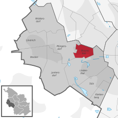
Lindenthal (Köln-Lindenthal (Stadtbezirk))
- city district of Cologne No. 3
Lindenthal, located in the city of Cologne, Germany, is primarily an urban area known for its parks and green spaces rather than traditional hiking trails. However, it offers some pleasant opportunities for walking and enjoying nature within the city.
Hiking and Walking Opportunities in Lindenthal:
-
Lindenthaler Tiergarten: This is a lovely park that provides tranquil walking paths and green areas perfect for a leisurely stroll. The park is home to a variety of wildlife and offers a peaceful escape from the urban environment.
-
Rothenburgswiesen: Adjacent to the Lindenthaler Tiergarten, this area features open fields and paths that can be explored on foot. It’s a great spot for a relaxed hike while enjoying the natural scenery.
-
Aachener Straße: This major street in Lindenthal is lined with shops and cafes, and while not a hiking trail, it offers a lively urban hiking experience. You can walk along it and explore local culture and cuisine.
-
Nearby Parks: The area surrounding Lindenthal has several parks, such as the Stadtwald (City Forest) and the Flora und Botanischer Garten Köln, that are accessible for hiking and walking. The Botanical Garden is particularly beautiful and provides scenic walking paths.
-
Access to Cologne's Riverbanks: Lindenthal is not far from the inner city and the banks of the Rhine River. Walking along the riverside is a popular activity, and the paths are well-maintained, providing a nice route for longer hikes.
Tips for Hiking in Urban Areas:
-
Wear Comfortable Shoes: Since much of the walking will be on paved paths or gravel, wear comfortable footwear suitable for urban hiking.
-
Stay Hydrated: Bring water, especially in warmer weather, and consider packing light snacks for your stroll.
-
Plan Your Route: Use maps or local guides to explore the best paths depending on how long you want to walk.
-
Explore Local Cafés: Take breaks in local cafés or parks to enjoy the atmosphere and refresh.
While Lindenthal itself may not have traditional hiking trails, its parks and proximity to the river offer enjoyable outdoor experiences right in the heart of Cologne. For more extensive hiking, consider venturing a bit further afield to the surrounding areas or natural reserves near the city.
- Country:

- Coordinates: 50° 55' 34" N, 6° 54' 36" E


- GPS tracks (wikiloc): [Link]
- Area: 41.6 sq km
- Wikipedia en: wiki(en)
- Wikipedia: wiki(de)
- Wikidata storage: Wikidata: Q518491
- Wikipedia Commons Category: [Link]
- Freebase ID: [/m/0bsrv_]
- GeoNames ID: Alt: [6947481]
- VIAF ID: Alt: [235937078]
- GND ID: Alt: [4098637-8]
- archINFORM location ID: [9063]
Includes regions:
Klettenberg
- city quarter No. 301 of Cologne, Germany
Klettenberg is a picturesque area in Cologne (Köln), Germany, known for its family-friendly atmosphere and natural beauty. While the area itself is more urban than rural, it offers several opportunities for hiking and walking in nearby parks and green spaces....
- Country:

- Coordinates: 50° 54' 40" N, 6° 55' 34" E


- GPS tracks (wikiloc): [Link]
Widdersdorf
- city quarter no. 309 of Cologne, Germany
Widdersdorf is a charming district located in the northwestern part of Cologne (Köln), Germany. While it may not be a major hiking hub, it offers some pleasant walking and nature experiences that can be enjoyable for outdoor enthusiasts....
- Country:

- Coordinates: 50° 57' 51" N, 6° 49' 48" E


- GPS tracks (wikiloc): [Link]


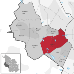
Lindenthal
- city quarter No. 303 of Cologne, Germany, and subdivision of city district Lindenthal
Lindenthal, a district of Cologne (Köln), is more known for its urban environment, parks, and gardens than for traditional hiking trails. However, there are still opportunities for outdoor activities and nature walks in and around the area. Here are some recommendations:...
- Country:

- Coordinates: 50° 55' 34" N, 6° 54' 36" E


- GPS tracks (wikiloc): [Link]


Braunsfeld
- city quarter No. 304 of Cologne, Germany
Braunsfeld is a district located in the city of Köln (Cologne), Germany. While Braunsfeld itself may not be a traditional hiking destination, it offers access to several green spaces and parks that can be great for walking and light hiking. Here are some suggestions for enjoying the outdoors around Braunsfeld:...
- Country:

- Coordinates: 50° 56' 13" N, 6° 54' 1" E


- GPS tracks (wikiloc): [Link]
Junkersdorf
- city quarter no. 305 of Cologne, Germany
Junkersdorf is a district located in the northwest of Cologne, Germany. While it might not be known as a traditional hiking destination, there are still some beautiful trails and nearby nature areas that can be explored. Here are some tips and information to consider if you're planning to hike in or around Junkersdorf:...
- Country:

- Coordinates: 50° 55' 55" N, 6° 51' 26" E


- GPS tracks (wikiloc): [Link]
Lövenich
- city quarter no. 308 of Cologne, Germany
Lövenich, a district in the city of Köln (Cologne), is not widely known as a hiking destination, but it offers some pleasant opportunities for walking and enjoying nature. Here’s what you should know about hiking in and around Lövenich:...
- Country:

- Coordinates: 50° 56' 48" N, 6° 49' 46" E


- GPS tracks (wikiloc): [Link]

