Lodrino, Lombardy (Lodrino)
.svg)
- Italian comune
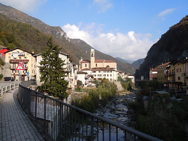
 Hiking in Lodrino, Lombardy
Lodrino, a charming town located in the province of Brescia in Lombardy, Italy, offers some excellent hiking opportunities for those looking to explore the natural beauty of the region. The area is characterized by its scenic landscapes, rolling hills, and proximity to the Oglio River.
Hiking Trails and Options:
-
Local Trails:
- Sentiero del Fiume Oglio: This trail runs alongside the Oglio River, providing a peaceful hiking experience with beautiful views of the river and surrounding nature. It's ideal for casual walks and can be enjoyed by families.
- Cresta di Lodrino: A more challenging hike, this trail leads to higher elevations, giving you panoramic views of the valley and the surrounding mountains. It's suitable for experienced hikers.
-
Oglio Valley:
- The Oglio Valley offers numerous paths that connect various towns and villages. These trails are often well-marked and provide a chance to explore the local flora and fauna, as well as historical sites.
-
Cultural and Scenic Routes:
- Many hikes in this region pass through vineyards, olive groves, and historic sites, allowing hikers to appreciate both nature and the cultural heritage of Lombardy.
Best Time to Hike:
- Spring and Fall: These seasons offer mild temperatures and stunning landscapes, making them ideal for hiking. Autumn especially provides vibrant foliage that enhances the scenic beauty of the trails.
Preparation:
- Gear: Make sure to wear appropriate hiking shoes and bring plenty of water, snacks, and a map or GPS device for navigation.
- Weather Check: Before heading out, check the weather conditions as they can vary, especially in the mountains.
Local Guidance:
- For more detailed information and guided tours, consider contacting local hiking clubs or visitor centers in Lodrino. They can provide maps and insights into the best routes tailored to your skill level.
Overall, Lodrino serves as a wonderful starting point for hikers looking to explore the natural beauty of Lombardy while enjoying its rich cultural history. Happy hiking!
- Country:

- Postal Code: 25060
- Local Dialing Code: 030
- Licence Plate Code: BS
- Coordinates: 45° 43' 0" N, 10° 17' 0" E


- GPS tracks (wikiloc): [Link]
- AboveSeaLevel: 725 м m
- Area: 16.5 sq km
- Population: 1669
- Web site: http://www.comune.lodrino.bs.it/
- Wikipedia en: wiki(en)
- Wikipedia: wiki(it)
- Wikidata storage: Wikidata: Q104978
- Wikipedia Commons Category: [Link]
- Freebase ID: [/m/044vby]
- GeoNames ID: Alt: [6542591]
- OSM relation ID: [45889]
- ISTAT ID: 017090
- Italian cadastre code: E652
Shares border with regions:

Casto
- Italian comune
Hiking in Casto
Casto, located in the Lombardy region of northern Italy, offers a charming backdrop for hiking enthusiasts. Nestled in the Prealps, this small village serves as a gateway to beautiful landscapes, rolling hills, and stunning views of the surrounding mountains. Here are some highlights and tips for hiking in and around Casto:...
- Country:
- Postal Code: 25070
- Local Dialing Code: 0365
- Licence Plate Code: BS
- Coordinates: 45° 42' 0" N, 10° 19' 0" E
- GPS tracks (wikiloc): [Link]
- AboveSeaLevel: 417 м m
- Area: 21.34 sq km
- Population: 1710
- Web site: [Link]

Marcheno
- Italian comune
Hiking in Marcheno
Marcheno, located in the Lombardy region of Italy, boasts beautiful natural scenery and a variety of hiking opportunities. Here are some highlights and tips for hiking in this area:...
- Country:
- Postal Code: 25060
- Local Dialing Code: 030
- Licence Plate Code: BS
- Coordinates: 45° 42' 0" N, 10° 13' 0" E
- GPS tracks (wikiloc): [Link]
- AboveSeaLevel: 372 м m
- Area: 22.74 sq km
- Population: 4246
- Web site: [Link]
Marmentino
- Italian comune
Hiking in Marmentino
Marmentino is a charming municipality located in the Province of Brescia in northern Italy. Nestled in the beautiful Italian Alps, it's known for its stunning landscapes, lush forests, and rustic charm. Hiking in Marmentino offers a variety of trails that cater to different skill levels and preferences, making it an excellent destination for both novice and experienced hikers....
- Country:
- Postal Code: 25060
- Local Dialing Code: 030
- Licence Plate Code: BS
- Coordinates: 45° 45' 0" N, 10° 17' 0" E
- GPS tracks (wikiloc): [Link]
- AboveSeaLevel: 875 м m
- Area: 18.04 sq km
- Population: 657
- Web site: [Link]
Pertica Alta
- Italian comune
Hiking in Pertica Alta
Pertica Alta is a picturesque area located in the province of Brescia, Italy, known for its stunning landscapes, rich flora and fauna, and various hiking trails suitable for different skill levels. Here are some key points to consider if you're planning to hike in Pertica Alta:...
- Country:
- Postal Code: 25070
- Local Dialing Code: 0365
- Licence Plate Code: BS
- Coordinates: 45° 45' 0" N, 10° 21' 0" E
- GPS tracks (wikiloc): [Link]
- AboveSeaLevel: 900 м m
- Area: 20.92 sq km
- Population: 563
- Web site: [Link]
Tavernole sul Mella
- Italian comune
Hiking in Tavernole sul Mella
Tavernole sul Mella is a picturesque village located in the province of Brescia in northern Italy. It's surrounded by beautiful landscapes that offer various hiking opportunities, making it a great destination for outdoor enthusiasts. Here’s some information to consider when hiking in and around Tavernole sul Mella:...
- Country:
- Postal Code: 25060
- Local Dialing Code: 030
- Licence Plate Code: BS
- Coordinates: 45° 44' 46" N, 10° 14' 22" E
- GPS tracks (wikiloc): [Link]
- AboveSeaLevel: 475 м m
- Area: 19.81 sq km
- Population: 1261
- Web site: [Link]