Tavernole sul Mella (Tavernole sul Mella)
.svg)
- Italian comune
 Hiking in Tavernole sul Mella
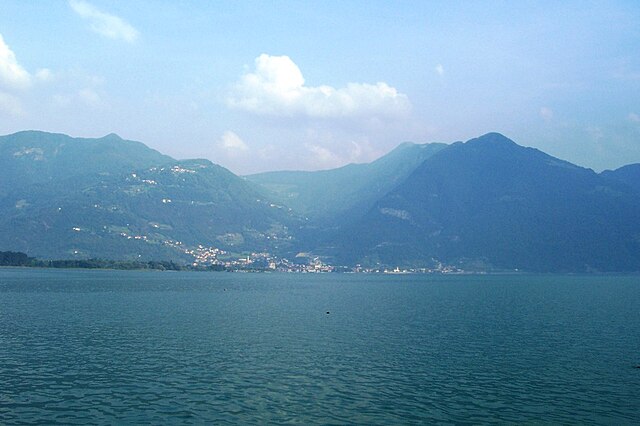
Tavernole sul Mella is a picturesque village located in the province of Brescia in northern Italy. It's surrounded by beautiful landscapes that offer various hiking opportunities, making it a great destination for outdoor enthusiasts. Here’s some information to consider when hiking in and around Tavernole sul Mella:
Scenic Trails
- Local Trails: Tavernole sul Mella has several local trails that wind through the lush mountains, offering stunning views of the surrounding valleys and forests. Many trails are well-marked, suitable for various skill levels.
- Brescian Alps: The nearby Brescian Alps provide more challenging hikes with opportunities to explore higher elevations, alpine meadows, and potentially see local wildlife.
Nature and Flora
- The region's landscapes are characterized by diverse flora and fauna. You might encounter various species of plants, trees, and possibly local wildlife such as deer, foxes, and numerous bird species.
Historical Sites
- Hiking in Tavernole sul Mella can also lead you to discover historical sites, including old churches and ruins that offer a glimpse into the region's rich cultural heritage.
Seasonal Considerations
- Spring and Autumn: These are beautiful times to hike, with mild weather and blooming wildflowers in spring or vibrant fall foliage.
- Summer: Although summer can be warmer, morning and late afternoon hikes are more comfortable, and the experience is enhanced by the lush surroundings.
- Winter: While winter hiking is possible, ensure you're equipped with proper gear, as some trails may be snow-covered or icy.
Practical Tips
- Maps: Always carry a detailed map or download GPS tracks to help navigate the trails.
- Safety: Inform someone about your hiking plans, especially if you're going on longer or more remote hikes.
- Local Guidance: Consider hiring a local guide for an enriching experience who can provide insight into the landscape, flora, and fauna.
Whether you're looking for a leisurely walk or a vigorous hike, Tavernole sul Mella and its surrounding areas offer a perfect blend of nature and culture for all hiking enthusiasts. Enjoy your adventure!
- Country:

- Postal Code: 25060
- Local Dialing Code: 030
- Licence Plate Code: BS
- Coordinates: 45° 44' 46" N, 10° 14' 22" E


- GPS tracks (wikiloc): [Link]
- AboveSeaLevel: 475 м m
- Area: 19.81 sq km
- Population: 1261
- Web site: http://www.comune.tavernolesulmella.bs.it/
- Wikipedia en: wiki(en)
- Wikipedia: wiki(it)
- Wikidata storage: Wikidata: Q112079
- Wikipedia Commons Category: [Link]
- Freebase ID: [/m/04d384]
- GeoNames ID: Alt: [6536374]
- OSM relation ID: [45950]
- UN/LOCODE: [ITTSM]
- ISTAT ID: 017183
- Italian cadastre code: C698
Shares border with regions:

Lodrino, Lombardy
- Italian comune
Hiking in Lodrino, Lombardy
Lodrino, a charming town located in the province of Brescia in Lombardy, Italy, offers some excellent hiking opportunities for those looking to explore the natural beauty of the region. The area is characterized by its scenic landscapes, rolling hills, and proximity to the Oglio River....
- Country:
- Postal Code: 25060
- Local Dialing Code: 030
- Licence Plate Code: BS
- Coordinates: 45° 43' 0" N, 10° 17' 0" E
- GPS tracks (wikiloc): [Link]
- AboveSeaLevel: 725 м m
- Area: 16.5 sq km
- Population: 1669
- Web site: [Link]

Marcheno
- Italian comune
Hiking in Marcheno
Marcheno, located in the Lombardy region of Italy, boasts beautiful natural scenery and a variety of hiking opportunities. Here are some highlights and tips for hiking in this area:...
- Country:
- Postal Code: 25060
- Local Dialing Code: 030
- Licence Plate Code: BS
- Coordinates: 45° 42' 0" N, 10° 13' 0" E
- GPS tracks (wikiloc): [Link]
- AboveSeaLevel: 372 м m
- Area: 22.74 sq km
- Population: 4246
- Web site: [Link]
Marmentino
- Italian comune
Hiking in Marmentino
Marmentino is a charming municipality located in the Province of Brescia in northern Italy. Nestled in the beautiful Italian Alps, it's known for its stunning landscapes, lush forests, and rustic charm. Hiking in Marmentino offers a variety of trails that cater to different skill levels and preferences, making it an excellent destination for both novice and experienced hikers....
- Country:
- Postal Code: 25060
- Local Dialing Code: 030
- Licence Plate Code: BS
- Coordinates: 45° 45' 0" N, 10° 17' 0" E
- GPS tracks (wikiloc): [Link]
- AboveSeaLevel: 875 м m
- Area: 18.04 sq km
- Population: 657
- Web site: [Link]
Pezzaze
- Italian comune
Hiking in Pezzaze
Pezzaze is a picturesque village located in the province of Brescia, Lombardy, Italy. Nestled in the scenic Valle di Pezzaze, it's surrounded by beautiful mountainous terrain that offers several hiking opportunities for both beginners and experienced hikers....
- Country:
- Postal Code: 25060
- Local Dialing Code: 030
- Licence Plate Code: BS
- Coordinates: 45° 46' 0" N, 10° 14' 0" E
- GPS tracks (wikiloc): [Link]
- AboveSeaLevel: 620 м m
- Area: 21.49 sq km
- Population: 1504
- Web site: [Link]
Pisogne
- Italian comune
Hiking in Pisogne
Pisogne is a charming town located along the eastern shore of Lake Iseo in Italy's Lombardy region. It offers a myriad of hiking opportunities for outdoor enthusiasts, featuring beautiful landscapes, scenic views of the lake, and the surrounding mountains. Here are some highlights about hiking in and around Pisogne:...
- Country:
- Postal Code: 25055
- Local Dialing Code: 0364
- Licence Plate Code: BS
- Coordinates: 45° 48' 39" N, 10° 6' 29" E
- GPS tracks (wikiloc): [Link]
- AboveSeaLevel: 187 м m
- Area: 49.23 sq km
- Population: 7982
- Web site: [Link]

Zone, Lombardy
- Italian comune
Hiking in Zone, Lombardy
Hiking in Zone, Lombardy, is a fantastic experience, especially if you enjoy breathtaking views, natural beauty, and a sense of tranquility. Located near the eastern shore of Lake Iseo in the Province of Brescia, Zone is a small town known for its stunning landscapes and rich hiking opportunities....
- Country:
- Postal Code: 25050
- Local Dialing Code: 030
- Licence Plate Code: BS
- Coordinates: 45° 46' 0" N, 10° 7' 0" E
- GPS tracks (wikiloc): [Link]
- AboveSeaLevel: 684 м m
- Area: 19.68 sq km
- Population: 1062
- Web site: [Link]