
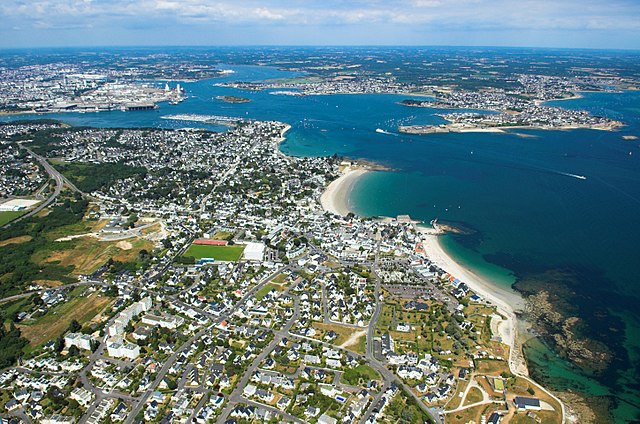
Lorient (Lorient)

- commune in Morbihan, France
- Country:

- Postal Code: 56100
- Coordinates: 47° 44' 45" N, 3° 21' 59" E


- GPS tracks (wikiloc): [Link]
- Area: 17.48 sq km
- Population: 57567
- Web site: https://www.lorient.bzh/
- Wikipedia en: wiki(en)
- Wikipedia: wiki(fr)
- Wikidata storage: Wikidata: Q71724
- Wikipedia Commons Gallery: [Link]
- Wikipedia Commons Category: [Link]
- Wikipedia Commons Maps Category: [Link]
- Freebase ID: [/m/01wg6h]
- Freebase ID: [/m/01wg6h]
- Freebase ID: [/m/01wg6h]
- Freebase ID: [/m/01wg6h]
- GeoNames ID: Alt: [2997577]
- GeoNames ID: Alt: [2997577]
- GeoNames ID: Alt: [2997577]
- GeoNames ID: Alt: [2997577]
- SIREN number: [215601212]
- SIREN number: [215601212]
- SIREN number: [215601212]
- SIREN number: [215601212]
- BnF ID: [15265370n]
- BnF ID: [15265370n]
- BnF ID: [15265370n]
- BnF ID: [15265370n]
- VIAF ID: Alt: [159458634]
- VIAF ID: Alt: [159458634]
- VIAF ID: Alt: [159458634]
- VIAF ID: Alt: [159458634]
- OSM relation ID: [30305]
- OSM relation ID: [30305]
- OSM relation ID: [30305]
- OSM relation ID: [30305]
- GND ID: Alt: [4255337-4]
- GND ID: Alt: [4255337-4]
- GND ID: Alt: [4255337-4]
- GND ID: Alt: [4255337-4]
- archINFORM location ID: [7087]
- archINFORM location ID: [7087]
- archINFORM location ID: [7087]
- archINFORM location ID: [7087]
- Library of Congress authority ID: Alt: [n81098918]
- Library of Congress authority ID: Alt: [n81098918]
- Library of Congress authority ID: Alt: [n81098918]
- Library of Congress authority ID: Alt: [n81098918]
- MusicBrainz area ID: [293f8c50-beef-4042-bea0-252b24f239e3]
- MusicBrainz area ID: [293f8c50-beef-4042-bea0-252b24f239e3]
- MusicBrainz area ID: [293f8c50-beef-4042-bea0-252b24f239e3]
- MusicBrainz area ID: [293f8c50-beef-4042-bea0-252b24f239e3]
- Encyclopædia Britannica Online ID: [place/Lorient]
- Encyclopædia Britannica Online ID: [place/Lorient]
- Encyclopædia Britannica Online ID: [place/Lorient]
- Encyclopædia Britannica Online ID: [place/Lorient]
- Gran Enciclopèdia Catalana ID: [0047602]
- Gran Enciclopèdia Catalana ID: [0047602]
- Gran Enciclopèdia Catalana ID: [0047602]
- Gran Enciclopèdia Catalana ID: [0047602]
- Encyclopædia Universalis ID: [lorient]
- Encyclopædia Universalis ID: [lorient]
- Encyclopædia Universalis ID: [lorient]
- Encyclopædia Universalis ID: [lorient]
- Facebook Places ID: [106487469388445]
- Facebook Places ID: [106487469388445]
- Facebook Places ID: [106487469388445]
- Facebook Places ID: [106487469388445]
- Twitter username: Alt: [VilledeLorient]
- Twitter username: Alt: [VilledeLorient]
- Twitter username: Alt: [VilledeLorient]
- Twitter username: Alt: [VilledeLorient]
- data.gouv.fr org ID: [ville-de-lorient]
- data.gouv.fr org ID: [ville-de-lorient]
- data.gouv.fr org ID: [ville-de-lorient]
- data.gouv.fr org ID: [ville-de-lorient]
- INSEE municipality code: 56121
- INSEE municipality code: 56121
- INSEE municipality code: 56121
- INSEE municipality code: 56121
- US National Archives Identifier: 10045161
- US National Archives Identifier: 10045161
- US National Archives Identifier: 10045161
- US National Archives Identifier: 10045161
Shares border with regions:


Ploemeur
- commune in Morbihan, France
- Country:
- Postal Code: 56270
- Coordinates: 47° 44' 9" N, 3° 25' 52" E
- GPS tracks (wikiloc): [Link]
- Area: 39.72 sq km
- Population: 17847
- Web site: [Link]


Quéven
- commune in Morbihan, France
- Country:
- Postal Code: 56530
- Coordinates: 47° 47' 19" N, 3° 24' 55" E
- GPS tracks (wikiloc): [Link]
- Area: 23.93 sq km
- Population: 8608
- Web site: [Link]

Caudan
- commune in Morbihan, France
- Country:
- Postal Code: 56850
- Coordinates: 47° 48' 32" N, 3° 20' 33" E
- GPS tracks (wikiloc): [Link]
- Area: 42.63 sq km
- Population: 6691
- Web site: [Link]

Larmor-Plage
- commune in Morbihan, France
- Country:
- Postal Code: 56260
- Coordinates: 47° 42' 23" N, 3° 23' 3" E
- GPS tracks (wikiloc): [Link]
- AboveSeaLevel: 9 м m
- Area: 7.27 sq km
- Population: 8182
- Web site: [Link]


Lanester
- commune in Morbihan, France
- Country:
- Postal Code: 56600
- Coordinates: 47° 45' 48" N, 3° 20' 20" E
- GPS tracks (wikiloc): [Link]
- AboveSeaLevel: 5 м m
- Area: 18.37 sq km
- Population: 22095
- Web site: [Link]