Mérens (Mérens)

- commune in Gers, France
- Country:

- Postal Code: 32360
- Coordinates: 43° 45' 13" N, 0° 32' 16" E


- GPS tracks (wikiloc): [Link]
- Area: 4.18 sq km
- Population: 63
- Wikipedia en: wiki(en)
- Wikipedia: wiki(fr)
- Wikidata storage: Wikidata: Q1006785
- Wikipedia Commons Category: [Link]
- Freebase ID: [/m/03nrr4f]
- GeoNames ID: Alt: [6453982]
- SIREN number: [213202518]
- INSEE municipality code: 32251
Shares border with regions:

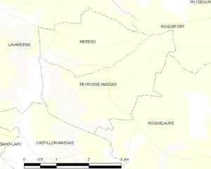
Peyrusse-Massas
- commune in Gers, France
- Country:
- Postal Code: 32360
- Coordinates: 43° 44' 17" N, 0° 33' 13" E
- GPS tracks (wikiloc): [Link]
- Area: 6.49 sq km
- Population: 99

Lavardens
- commune in Gers, France
- Country:
- Postal Code: 32360
- Coordinates: 43° 45' 39" N, 0° 30' 49" E
- GPS tracks (wikiloc): [Link]
- Area: 30.55 sq km
- Population: 394
Roquefort
- commune in Gers, France
- Country:
- Postal Code: 32390
- Coordinates: 43° 45' 30" N, 0° 36' 11" E
- GPS tracks (wikiloc): [Link]
- Area: 7.21 sq km
- Population: 292