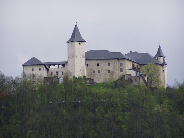
Mölbling (Mölbling)
- municipality in Austria
Mölbling, situated in Austria, is a lesser-known but beautiful hiking destination. It's surrounded by picturesque landscapes, including rolling hills, forests, and streams, making it ideal for those seeking tranquility in nature. Here are a few aspects to consider when hiking in the Mölbling area:
Trails
-
Local Trails: The area features various marked trails suitable for different skill levels, from easy walks to more challenging hikes. Check local maps for specific routes that highlight the region's natural beauty.
-
Scenic Views: Many trails offer stunning vistas, so look for viewpoints that capture the essence of the surrounding countryside.
Flora and Fauna
- While hiking, you may encounter diverse plant species and wildlife. Keep an eye out for local birds and other animals, as well as the rich vegetation that thrives in the region.
Best Time to Hike
- The best times for hiking in Mölbling are generally late spring to early autumn when the weather is mild and the trails are fully accessible. Summer can be warm, so carry plenty of water.
Preparation
- Gear: Wear sturdy hiking boots and bring appropriate clothing for the weather. Layering is often advisable.
- Navigation: Carry a map or GPS device to stay on the right trail. It’s important to familiarize yourself with the area before you head out.
Local Tips
- Engage with local hiking groups, if available, as they can provide insights and possibly lead guided hikes.
- Be mindful of local regulations, wildlife, and keep the trails clean by following Leave No Trace principles.
Nearby Attractions
If you have extra time, consider exploring other nearby towns or natural parks that may offer additional recreational opportunities, cultural experiences, or dining options.
Always check the local conditions and prepare accordingly before heading out, and enjoy your hiking experience in Mölbling!
- Country:

- Local Dialing Code: 0 42 62
- Licence Plate Code: SV
- Coordinates: 46° 51' 42" N, 14° 26' 47" E


- GPS tracks (wikiloc): [Link]
- AboveSeaLevel: 585 м m
- Area: 48.73 sq km
- Population: 1315
- Web site: http://www.moelbling.at
- Wikipedia en: wiki(en)
- Wikipedia: wiki(de)
- Wikidata storage: Wikidata: Q662243
- Wikipedia Commons Gallery: [Link]
- Wikipedia Commons Category: [Link]
- Freebase ID: [/m/02qqf7c]
- GeoNames ID: Alt: [2771313]
- VIAF ID: Alt: [152308142]
- Austrian municipality key: [20520]
Shares border with regions:

Althofen
- municipality in Austria
Althofen, located in Austria’s Carinthia region, is a charming town surrounded by picturesque landscapes, making it an excellent destination for hiking enthusiasts. Here are some key details about hiking in and around Althofen:...
- Country:

- Postal Code: 9330
- Local Dialing Code: 0 42 62
- Licence Plate Code: SV
- Coordinates: 46° 52' 0" N, 14° 28' 0" E


- GPS tracks (wikiloc): [Link]
- AboveSeaLevel: 718 м m
- Area: 12.29 sq km
- Population: 4759
- Web site: [Link]

Straßburg
- municipality in Austria
It looks like there's a bit of confusion here. Straßburg (or Strasbourg) is a city in France, located in the Alsace region, while Austria has a different set of hiking destinations. However, I can provide information about hiking opportunities in Austria if you're interested!...
- Country:

- Postal Code: 9341
- Local Dialing Code: 0 42 66
- Licence Plate Code: SV
- Coordinates: 46° 53' 44" N, 14° 19' 51" E


- GPS tracks (wikiloc): [Link]
- AboveSeaLevel: 642 м m
- Area: 97.58 sq km
- Population: 2095
- Web site: [Link]

Gurk
- municipality in Austria
Gurk is a charming small town located in the state of Carinthia, Austria. It is surrounded by stunning natural landscapes, making it an excellent destination for hiking enthusiasts....
- Country:

- Postal Code: 9342
- Local Dialing Code: 04266
- Licence Plate Code: SV
- Coordinates: 46° 52' 31" N, 14° 17' 20" E


- GPS tracks (wikiloc): [Link]
- AboveSeaLevel: 662 м m
- Area: 39.67 sq km
- Population: 1226
- Web site: [Link]

Sankt Georgen am Längsee
- municipality in Austria
 Hiking in Sankt Georgen am Längsee
Sankt Georgen am Längsee is a charming destination for hikers, situated in the Carinthia region of Austria. The area is known for its beautiful landscapes, lush forests, and the picturesque Längsee, a serene lake that provides a stunning backdrop for outdoor activities....
- Country:

- Local Dialing Code: 0 42 13
- Licence Plate Code: SV
- Coordinates: 46° 46' 48" N, 14° 25' 55" E


- GPS tracks (wikiloc): [Link]
- AboveSeaLevel: 537 м m
- Area: 69.8 sq km
- Population: 3648
- Web site: [Link]

Kappel am Krappfeld
- municipality in Austria
Kappel am Krappfeld, located in the Carinthia region of Austria, offers a variety of hiking opportunities that cater to different skill levels. The region is characterized by its picturesque landscapes, rolling hills, and charming villages, making it a great destination for outdoor enthusiasts....
- Country:

- Postal Code: 9321
- Local Dialing Code: 0 42 62
- Licence Plate Code: SV
- Coordinates: 46° 50' 16" N, 14° 29' 10" E


- GPS tracks (wikiloc): [Link]
- AboveSeaLevel: 594 м m
- Area: 49.7 sq km
- Population: 1951
- Web site: [Link]
Frauenstein
- municipality in Austria
Frauenstein, located in the scenic region of Styria, Austria, is a lovely destination for hiking enthusiasts. The area is surrounded by beautiful landscapes, lush forests, and rolling hills, making it ideal for both casual walkers and experienced hikers. Here are some highlights and considerations for hiking in and around Frauenstein:...
- Country:

- Postal Code: 9311
- Local Dialing Code: 0 42 12
- Licence Plate Code: SV
- Coordinates: 46° 48' 49" N, 14° 22' 3" E


- GPS tracks (wikiloc): [Link]
- AboveSeaLevel: 630 м m
- Area: 93.53 sq km
- Population: 3597
- Web site: [Link]