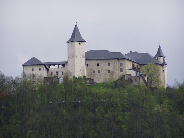
Sankt Veit an der Glan District (Bezirk Sankt Veit an der Glan)

- district of Austria
 Hiking in Sankt Veit an der Glan District
Sankt Veit an der Glan District, located in the state of Carinthia, Austria, offers an array of beautiful hiking opportunities. This region is characterized by its stunning landscapes, including rolling hills, forests, and picturesque lakes, making it ideal for outdoor enthusiasts.
Popular Hiking Areas:
-
Basilika St. Veit: Starting from the district's capital, you can explore trails that lead to the surrounding forests and hills, offering panoramic views of the area.
-
Wöllaner Nock: Located not far from Sankt Veit, this mountain offers various trails, including easier routes suitable for families. The trails provide breathtaking views of the surrounding valleys.
-
Klagenfurt's Moor Nature Reserves: Enjoy serene walks through protected moorlands where you can observe unique flora and fauna.
-
Lake Gösselsdorf: This tranquil lake area is not just for swimming and relaxing but also offers several scenic hiking paths around the water, perfect for a leisurely day out.
Trail Types:
- Easy Hikes: There are numerous flat, well-marked paths ideal for families or those looking for leisurely strolls.
- Moderate Trails: These paths often have some elevation changes and are suitable for hikers with a reasonable fitness level.
- Challenging Hikes: For more experienced hikers, there are steep trails that require good physical condition and stamina, often leading to picturesque viewpoints.
Tips for Hiking in Sankt Veit an der Glan:
- Stay Hydrated: Always carry enough water, especially on warmer days.
- Weather Check: The weather can change rapidly in this region; always check the forecast before heading out.
- Appropriate Gear: Wear sturdy hiking boots and dress in layers to adjust to changing conditions.
- Navigation Tools: While many trails are well-marked, a map or GPS can be helpful, especially on less traveled paths.
- Respect Nature: Follow Leave No Trace principles to preserve the beauty of the area.
Best Times to Hike:
The best time for hiking in Sankt Veit an der Glan is typically from late spring to early autumn (May to October), when trails are clear of snow and the weather is pleasant. Each season offers a different experience, with autumn showcasing beautiful foliage and spring bringing blooming wildflowers.
Sankt Veit an der Glan District provides a wealth of opportunities for hikers of all skill levels, making it a fantastic destination for your next outdoor adventure!
- Country:

- Licence Plate Code: SV
- Coordinates: 46° 51' 43" N, 14° 25' 41" E


- GPS tracks (wikiloc): [Link]
- AboveSeaLevel: 675 м m
- Area: 1493.67 sq km
- Web site: http://www.verwaltung.ktn.gv.at/cgi-bin/evoweb.dll/web/akl/379_DE
- Wikipedia en: wiki(en)
- Wikipedia: wiki(de)
- Wikidata storage: Wikidata: Q660255
- Wikipedia Commons Category: [Link]
- Freebase ID: [/m/0c2wll]
- GeoNames ID: Alt: [2766358]
- archINFORM location ID: [14652]
Includes regions:

Althofen
- municipality in Austria
Hiking in Althofen
Althofen, located in Austria’s Carinthia region, is a charming town surrounded by picturesque landscapes, making it an excellent destination for hiking enthusiasts. Here are some key details about hiking in and around Althofen:...
- Country:
- Postal Code: 9330
- Local Dialing Code: 0 42 62
- Licence Plate Code: SV
- Coordinates: 46° 52' 0" N, 14° 28' 0" E
- GPS tracks (wikiloc): [Link]
- AboveSeaLevel: 718 м m
- Area: 12.29 sq km
- Population: 4759
- Web site: [Link]

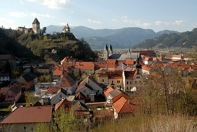
Sankt Veit an der Glan
- municipality in Austria
Hiking in Sankt Veit an der Glan
Sankt Veit an der Glan, located in Austria's Carinthia region, is an excellent destination for hiking enthusiasts. The area boasts a stunning natural landscape, with rolling hills, lush valleys, and nearby mountains, making it ideal for a variety of hiking experiences suitable for different skill levels....
- Country:
- Postal Code: 9300
- Local Dialing Code: 04212
- Licence Plate Code: SV
- Coordinates: 46° 46' 0" N, 14° 21' 37" E
- GPS tracks (wikiloc): [Link]
- AboveSeaLevel: 482 м m
- Area: 50.73 sq km
- Population: 12547
- Web site: [Link]
Straßburg
- municipality in Austria
Hiking in Straßburg
It looks like there's a bit of confusion here. Straßburg (or Strasbourg) is a city in France, located in the Alsace region, while Austria has a different set of hiking destinations. However, I can provide information about hiking opportunities in Austria if you're interested!...
- Country:
- Postal Code: 9341
- Local Dialing Code: 0 42 66
- Licence Plate Code: SV
- Coordinates: 46° 53' 44" N, 14° 19' 51" E
- GPS tracks (wikiloc): [Link]
- AboveSeaLevel: 642 м m
- Area: 97.58 sq km
- Population: 2095
- Web site: [Link]

Hüttenberg
- municipality in Austria
Hiking in Hüttenberg
Hüttenberg, located in the Styria region of Austria, is a charming destination for hikers, offering a variety of trails and natural landscapes. The area is characterized by its beautiful mountains, forests, and meadows, making it an excellent spot for outdoor enthusiasts....
- Country:
- Postal Code: 9375
- Local Dialing Code: 04263
- Licence Plate Code: SV
- Coordinates: 46° 56' 23" N, 14° 32' 55" E
- GPS tracks (wikiloc): [Link]
- AboveSeaLevel: 786 м m
- Area: 134.52 sq km
- Population: 1414
- Web site: [Link]

Deutsch-Griffen
- municipality in Austria
Hiking in Deutsch-Griffen
Deutsch-Griffen is a picturesque village located in Austria, nestled in the stunning Carinthian region. The area is renowned for its natural beauty, making it an excellent destination for hiking enthusiasts....
- Country:
- Postal Code: 9572
- Local Dialing Code: 0 42 79
- Licence Plate Code: SV
- Coordinates: 46° 51' 18" N, 14° 4' 26" E
- GPS tracks (wikiloc): [Link]
- AboveSeaLevel: 847 м m
- Area: 71.41 sq km
- Population: 908
- Web site: [Link]

Gurk
- municipality in Austria
Hiking in Gurk
Gurk is a charming small town located in the state of Carinthia, Austria. It is surrounded by stunning natural landscapes, making it an excellent destination for hiking enthusiasts....
- Country:
- Postal Code: 9342
- Local Dialing Code: 04266
- Licence Plate Code: SV
- Coordinates: 46° 52' 31" N, 14° 17' 20" E
- GPS tracks (wikiloc): [Link]
- AboveSeaLevel: 662 м m
- Area: 39.67 sq km
- Population: 1226
- Web site: [Link]

Eberstein
- municipality in Austria
Hiking in Eberstein
Eberstein, a beautiful municipality located in Carinthia, Austria, offers hiking enthusiasts a range of trails that cater to different skill levels and preferences. Nestled in the picturesque landscape of the Austrian Alps, the area is characterized by lush forests, rolling hills, and stunning mountain views....
- Country:
- Postal Code: 9372
- Local Dialing Code: 04264
- Licence Plate Code: SV
- Coordinates: 46° 48' 29" N, 14° 33' 36" E
- GPS tracks (wikiloc): [Link]
- AboveSeaLevel: 580 м m
- Area: 65.2 sq km
- Population: 1271
- Web site: [Link]

Mölbling
- municipality in Austria
Hiking in Mölbling
Mölbling, situated in Austria, is a lesser-known but beautiful hiking destination. It's surrounded by picturesque landscapes, including rolling hills, forests, and streams, making it ideal for those seeking tranquility in nature. Here are a few aspects to consider when hiking in the Mölbling area:...
- Country:
- Local Dialing Code: 0 42 62
- Licence Plate Code: SV
- Coordinates: 46° 51' 42" N, 14° 26' 47" E
- GPS tracks (wikiloc): [Link]
- AboveSeaLevel: 585 м m
- Area: 48.73 sq km
- Population: 1315
- Web site: [Link]

Brückl
- municipality in Austria
Hiking in Brückl
Brückl is a charming town in Austria, located in the Carinthia region. It offers a variety of hiking opportunities that cater to different skill levels and interests. Here are some highlights and tips for hiking in and around Brückl:...
- Country:
- Postal Code: 9371
- Local Dialing Code: 04214
- Licence Plate Code: SV
- Coordinates: 46° 45' 11" N, 14° 32' 9" E
- GPS tracks (wikiloc): [Link]
- AboveSeaLevel: 510 м m
- Area: 46.62 sq km
- Population: 2717
- Web site: [Link]

Micheldorf
- municipality in Austria
Hiking in Micheldorf
Micheldorf, a charming village in the Upper Austria region, is a great starting point for hiking enthusiasts. Nestled near the foothills of the Alps, the area offers a variety of scenic trails suitable for different skill levels. Here are some highlights you might enjoy while hiking in and around Micheldorf:...
- Country:
- Postal Code: 9322
- Local Dialing Code: 0 42 68
- Licence Plate Code: SV
- Coordinates: 46° 54' 50" N, 14° 25' 40" E
- GPS tracks (wikiloc): [Link]
- AboveSeaLevel: 622 м m
- Area: 16.99 sq km
- Population: 1000
- Web site: [Link]

Sankt Georgen am Längsee
- municipality in Austria
Hiking in Sankt Georgen am Längsee
Sankt Georgen am Längsee is a charming destination for hikers, situated in the Carinthia region of Austria. The area is known for its beautiful landscapes, lush forests, and the picturesque Längsee, a serene lake that provides a stunning backdrop for outdoor activities....
- Country:
- Local Dialing Code: 0 42 13
- Licence Plate Code: SV
- Coordinates: 46° 46' 48" N, 14° 25' 55" E
- GPS tracks (wikiloc): [Link]
- AboveSeaLevel: 537 м m
- Area: 69.8 sq km
- Population: 3648
- Web site: [Link]

Kappel am Krappfeld
- municipality in Austria
Hiking in Kappel am Krappfeld
Kappel am Krappfeld, located in the Carinthia region of Austria, offers a variety of hiking opportunities that cater to different skill levels. The region is characterized by its picturesque landscapes, rolling hills, and charming villages, making it a great destination for outdoor enthusiasts....
- Country:
- Postal Code: 9321
- Local Dialing Code: 0 42 62
- Licence Plate Code: SV
- Coordinates: 46° 50' 16" N, 14° 29' 10" E
- GPS tracks (wikiloc): [Link]
- AboveSeaLevel: 594 м m
- Area: 49.7 sq km
- Population: 1951
- Web site: [Link]

Liebenfels
- municipality in Austria
Hiking in Liebenfels
Liebenfels, located in Carinthia, Austria, is a picturesque village known for its stunning landscapes and historical significance. Hiking in this region offers a variety of trails that cater to different skill levels, making it suitable for both casual walkers and more experienced hikers....
- Country:
- Postal Code: 9556
- Local Dialing Code: 04215
- Licence Plate Code: SV
- Coordinates: 46° 44' 17" N, 14° 17' 13" E
- GPS tracks (wikiloc): [Link]
- AboveSeaLevel: 491 м m
- Area: 58.85 sq km
- Population: 3286
- Web site: [Link]

Klein Sankt Paul
- municipality in Austria
Hiking in Klein Sankt Paul
Klein Sankt Paul is a charming village located in the Southern part of Austria, in the Carinthia region. It is surrounded by beautiful landscapes that are great for hiking and outdoor activities. Here are some details about hiking in the area:...
- Country:
- Postal Code: 9373
- Local Dialing Code: 04264
- Licence Plate Code: SV
- Coordinates: 46° 50' 10" N, 14° 32' 30" E
- GPS tracks (wikiloc): [Link]
- AboveSeaLevel: 633 м m
- Area: 68.58 sq km
- Population: 1820
- Web site: [Link]
Metnitz
- municipality in Austria
Hiking in Metnitz
Metnitz is a beautiful village located in the Carinthia region of Austria, surrounded by stunning natural landscapes, making it a great area for hiking enthusiasts. Here are some highlights about hiking in and around Metnitz:...
- Country:
- Postal Code: 9363
- Local Dialing Code: 04267
- Licence Plate Code: SV
- Coordinates: 46° 58' 50" N, 14° 13' 2" E
- GPS tracks (wikiloc): [Link]
- AboveSeaLevel: 851 м m
- Area: 223.14 sq km
- Population: 2011
- Web site: [Link]

Weitensfeld im Gurktal
- municipality in Austria
Hiking in Weitensfeld im Gurktal
Weitensfeld im Gurktal is a picturesque village located in the Gurktal Valley in the Carinthia region of Austria. This area offers hikers a variety of trails and stunning natural scenery, making it an excellent destination for both novice and experienced hikers. Here are some highlights to consider when hiking in this region:...
- Country:
- Postal Code: 9344
- Local Dialing Code: 04265
- Licence Plate Code: SV
- Coordinates: 46° 50' 55" N, 14° 11' 30" E
- GPS tracks (wikiloc): [Link]
- AboveSeaLevel: 702 м m
- Area: 95.76 sq km
- Population: 2091
- Web site: [Link]
Frauenstein
- municipality in Austria
Hiking in Frauenstein
Frauenstein, located in the scenic region of Styria, Austria, is a lovely destination for hiking enthusiasts. The area is surrounded by beautiful landscapes, lush forests, and rolling hills, making it ideal for both casual walkers and experienced hikers. Here are some highlights and considerations for hiking in and around Frauenstein:...
- Country:
- Postal Code: 9311
- Local Dialing Code: 0 42 12
- Licence Plate Code: SV
- Coordinates: 46° 48' 49" N, 14° 22' 3" E
- GPS tracks (wikiloc): [Link]
- AboveSeaLevel: 630 м m
- Area: 93.53 sq km
- Population: 3597
- Web site: [Link]

Guttaring
- municipality in Austria
Hiking in Guttaring
Guttaring is a small village located in the Carinthia region of Austria, surrounded by stunning natural landscapes, making it an excellent destination for hiking enthusiasts. The area features a variety of trails catering to different skill levels, from leisurely walks to more challenging mountain hikes....
- Country:
- Postal Code: 9334
- Local Dialing Code: 04262
- Licence Plate Code: SV
- Coordinates: 46° 53' 22" N, 14° 30' 42" E
- GPS tracks (wikiloc): [Link]
- AboveSeaLevel: 624 м m
- Area: 55.29 sq km
- Population: 1470
- Web site: [Link]

Glödnitz
- municipality in Austria
Hiking in Glödnitz
Glödnitz is a small village located in the Carinthia region of Austria, known for its beautiful natural landscapes and outdoor recreational opportunities. Hiking in Glödnitz offers a chance to explore scenic trails, enjoy the fresh air, and immerse yourself in the stunning alpine environment....
- Country:
- Postal Code: 9346
- Local Dialing Code: 0 42 65
- Licence Plate Code: SV
- Coordinates: 46° 52' 0" N, 14° 7' 0" E
- GPS tracks (wikiloc): [Link]
- AboveSeaLevel: 748 м m
- Area: 74.65 sq km
- Population: 807
- Web site: [Link]
Friesach
- municipality in Austria
Hiking in Friesach
Friesach, located in Carinthia, Austria, is a charming town surrounded by stunning natural landscapes, making it an excellent destination for hiking enthusiasts. The region showcases a variety of trails that cater to different skill levels, from leisurely walks to more challenging hikes....
- Country:
- Postal Code: 9360
- Local Dialing Code: 0 42 68
- Licence Plate Code: SV
- Coordinates: 46° 57' 9" N, 14° 24' 35" E
- GPS tracks (wikiloc): [Link]
- AboveSeaLevel: 634 м m
- Area: 120.83 sq km
- Population: 4947
- Web site: [Link]