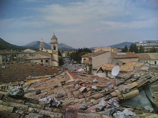
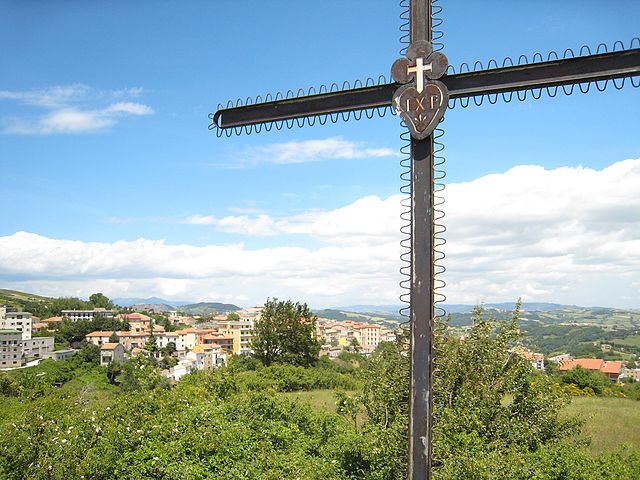
Macchiagodena (Macchiagodena)
.svg)
- Italian comune
 Hiking in Macchiagodena
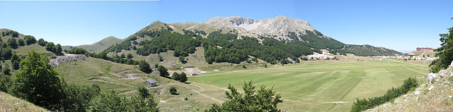
Macchiagodena, located in the Molise region of Italy, is a charming area offering beautiful landscapes and ample opportunities for hiking enthusiasts. Here are some highlights about hiking in Macchiagodena:
Trails and Landscapes
-
Varied Terrain: The region features a mix of mountains, hills, and valleys, providing hikers with diverse terrain. You can experience picturesque views of the Apennines and lush woodlands.
-
Natural Parks: Macchiagodena is near the Mainarde Mountain area and the Parco Nazionale d'Abruzzo, Lazio e Molise, which offer numerous well-marked trails that range from easy walks to more challenging hikes.
-
Scenic Routes: Trails often lead through ancient forests, charming villages, and along rivers. You may discover beautiful viewpoints, particularly at higher elevations, where you can enjoy panoramas of the surrounding landscape.
Local Attractions
-
Castles and Historical Sites: While hiking, you may come across historical sites like ancient castles (e.g., the ruins of the Castello di Macchiagodena) and churches, enriching your outdoor experience with cultural context.
-
Wildlife Watching: The area is home to various wildlife, and hikers may encounter deer, foxes, and numerous bird species. Bring binoculars if you're interested in birdwatching.
Best Time to Hike
- The best times to hike in Macchiagodena are during spring (April to June) and autumn (September to October), when the weather is mild, and the natural surroundings are particularly beautiful.
Tips for Hikers
-
Preparation: Ensure you have proper hiking gear, including sturdy footwear, weather-appropriate clothing, and plenty of water and snacks.
-
Navigation: While many trails are marked, carrying a map or having a GPS device can be beneficial since some paths can be less frequented.
-
Local Guides: Consider hiring a local guide if you’re unfamiliar with the region, as they can provide insights into the flora, fauna, and history of the area.
Conclusion
Hiking in Macchiagodena offers a unique blend of nature and culture, making it an excellent destination for outdoor enthusiasts. Be prepared to enjoy breathtaking scenery, rich history, and the tranquility of the Italian countryside.
- Country:

- Postal Code: 86096
- Local Dialing Code: 0865
- Licence Plate Code: IS
- Coordinates: 41° 34' 0" N, 14° 24' 0" E


- GPS tracks (wikiloc): [Link]
- AboveSeaLevel: 864 м m
- Area: 34.35 sq km
- Population: 1808
- Web site: http://www.comune.macchiagodena.is.it/
- Wikipedia en: wiki(en)
- Wikipedia: wiki(it)
- Wikidata storage: Wikidata: Q279247
- Wikipedia Commons Category: [Link]
- Freebase ID: [/m/0btnms]
- GeoNames ID: Alt: [6541374]
- VIAF ID: Alt: [243256904]
- OSM relation ID: [41357]
- ISTAT ID: 094026
- Italian cadastre code: E779
Shares border with regions:


Sant'Elena Sannita
- Italian comune
Hiking in Sant'Elena Sannita
Sant'Elena Sannita is a picturesque village located in the province of Campobasso in the Molise region of Italy. The area is known for its beautiful landscapes, rich cultural heritage, and opportunities for outdoor activities, including hiking....
- Country:
- Postal Code: 86099
- Local Dialing Code: 0874
- Licence Plate Code: IS
- Coordinates: 41° 35' 0" N, 14° 28' 0" E
- GPS tracks (wikiloc): [Link]
- AboveSeaLevel: 780 м m
- Area: 14.08 sq km
- Population: 295
- Web site: [Link]

Bojano
- Italian comune
Hiking in Bojano
Bojano, located in the Molise region of Italy, offers a unique blend of natural beauty, rich history, and local culture, making it a worthwhile destination for hiking enthusiasts. Here are some highlights for hiking in and around Bojano:...
- Country:
- Postal Code: 86021
- Local Dialing Code: 0874
- Licence Plate Code: CB
- Coordinates: 41° 29' 0" N, 14° 28' 0" E
- GPS tracks (wikiloc): [Link]
- AboveSeaLevel: 480 м m
- Area: 52.63 sq km
- Population: 8178
- Web site: [Link]

San Massimo
- Italian comune
Hiking in San Massimo
San Massimo, located in the Molise region of Italy, is known for its stunning natural landscapes and rich cultural heritage. It offers a variety of hiking opportunities suitable for different skill levels. Here are some key points about hiking in San Massimo:...
- Country:
- Postal Code: 86027
- Local Dialing Code: 0874
- Licence Plate Code: CB
- Coordinates: 41° 29' 0" N, 14° 25' 0" E
- GPS tracks (wikiloc): [Link]
- AboveSeaLevel: 630 м m
- Area: 27.33 sq km
- Population: 873
- Web site: [Link]
Cantalupo nel Sannio
- Italian comune
Hiking in Cantalupo nel Sannio
Cantalupo nel Sannio is a picturesque village located in the Molise region of Italy, known for its natural beauty and rich cultural heritage. Hiking in this area offers a variety of trails that cater to different skill levels, allowing hikers to immerse themselves in the stunning landscapes and enjoy the tranquility of the surrounding nature....
- Country:
- Postal Code: 86092
- Local Dialing Code: 0865
- Licence Plate Code: IS
- Coordinates: 41° 31' 0" N, 14° 24' 0" E
- GPS tracks (wikiloc): [Link]
- AboveSeaLevel: 587 м m
- Area: 15.64 sq km
- Population: 764
- Web site: [Link]
Carpinone
- Italian comune
Hiking in Carpinone
Carpinone is a picturesque village located in the Molise region of Italy, surrounded by the stunning Apennine Mountains. Hiking in this area offers a fantastic opportunity to explore unspoiled nature, historic sites, and local culture....
- Country:
- Postal Code: 86093
- Local Dialing Code: 0865
- Licence Plate Code: IS
- Coordinates: 41° 36' 0" N, 14° 19' 0" E
- GPS tracks (wikiloc): [Link]
- AboveSeaLevel: 636 м m
- Area: 32.43 sq km
- Population: 1126
- Web site: [Link]

Frosolone
- Italian comune
Hiking in Frosolone
Frosolone, a charming town in the Molise region of Italy, is surrounded by beautiful landscapes and offers a variety of hiking opportunities. Nestled in the Apennine mountains, it features rolling hills, scenic valleys, and abundant nature, making it an excellent destination for outdoor enthusiasts. Here are some highlights for hiking in and around Frosolone:...
- Country:
- Postal Code: 86095
- Local Dialing Code: 0874
- Licence Plate Code: IS
- Coordinates: 41° 36' 0" N, 14° 27' 0" E
- GPS tracks (wikiloc): [Link]
- AboveSeaLevel: 894 м m
- Area: 49.89 sq km
- Population: 3172
- Web site: [Link]
Santa Maria del Molise
- Italian comune
Hiking in Santa Maria del Molise
Santa Maria del Molise is a small, picturesque village located in the Molise region of Italy, known for its stunning natural landscapes and rich cultural heritage. The surrounding area offers a variety of hiking opportunities suitable for different skill levels, making it a great destination for outdoor enthusiasts....
- Country:
- Postal Code: 86090
- Local Dialing Code: 0865
- Licence Plate Code: IS
- Coordinates: 41° 33' 0" N, 14° 22' 0" E
- GPS tracks (wikiloc): [Link]
- AboveSeaLevel: 587 м m
- Area: 17.2 sq km
- Population: 675
- Web site: [Link]