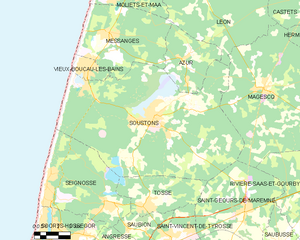
Magescq (Magescq)
- commune in Landes, France
- Country:

- Postal Code: 40140
- Coordinates: 43° 46' 46" N, 1° 13' 2" E


- GPS tracks (wikiloc): [Link]
- Area: 77.12 sq km
- Population: 2035
- Web site: http://www.mairie-magescq.fr
- Wikipedia en: wiki(en)
- Wikipedia: wiki(fr)
- Wikidata storage: Wikidata: Q633038
- Wikipedia Commons Category: [Link]
- Freebase ID: [/m/03nvxjj]
- GeoNames ID: Alt: [6433878]
- SIREN number: [214001687]
- BnF ID: [152591100]
- MusicBrainz area ID: [fc2b464d-e079-4b3e-9fab-02e64323f288]
- WOEID: [609204]
- INSEE municipality code: 40168
Shares border with regions:


Castets
- commune in Landes, France
- Country:

- Postal Code: 40260
- Coordinates: 43° 52' 57" N, 1° 8' 49" E


- GPS tracks (wikiloc): [Link]
- Area: 90.18 sq km
- Population: 2120
- Web site: [Link]


Saint-Geours-de-Maremne
- commune in Landes, France
- Country:

- Postal Code: 40230
- Coordinates: 43° 41' 14" N, 1° 13' 45" E


- GPS tracks (wikiloc): [Link]
- Area: 42.9 sq km
- Population: 2582
- Web site: [Link]


Rivière-Saas-et-Gourby
- commune in Landes, France
- Country:

- Postal Code: 40180
- Coordinates: 43° 40' 45" N, 1° 9' 6" E


- GPS tracks (wikiloc): [Link]
- Area: 27.37 sq km
- Population: 1240


Saint-Paul-lès-Dax
- commune in Landes, France
- Country:

- Postal Code: 40990
- Coordinates: 43° 43' 32" N, 1° 3' 10" E


- GPS tracks (wikiloc): [Link]
- Area: 58.45 sq km
- Population: 13040


Léon
- commune in Landes, France
- Country:

- Postal Code: 40550
- Coordinates: 43° 52' 37" N, 1° 18' 11" E


- GPS tracks (wikiloc): [Link]
- Area: 64.45 sq km
- Population: 1963
- Web site: [Link]


Soustons
- commune in Landes, France
- Country:

- Postal Code: 40140
- Coordinates: 43° 45' 12" N, 1° 19' 40" E


- GPS tracks (wikiloc): [Link]
- Area: 100.38 sq km
- Population: 7664
- Web site: [Link]


Herm
- commune in Landes, France
- Country:

- Postal Code: 40990
- Coordinates: 43° 48' 27" N, 1° 8' 41" E


- GPS tracks (wikiloc): [Link]
- Area: 52.08 sq km
- Population: 1132
