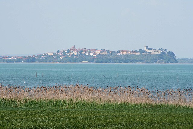
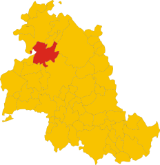
Magione (Magione)
.svg)
- Italian comune
 Hiking in Magione
Magione, located in the Umbria region of Italy, is a charming town situated near the western shore of Lake Trasimeno, surrounded by beautiful landscapes, vineyards, and charming rural areas. While Magione itself is not a renowned hiking destination, it offers access to a variety of trails and outdoor activities that are popular with locals and visitors alike.
Here are some key aspects to consider when hiking in and around Magione:
Hiking Trails
-
Lake Trasimeno Trails: The area around Lake Trasimeno offers numerous walking and hiking paths with stunning views of the lake and surrounding hills. The route around the lake itself is relatively flat and is suitable for walkers of all abilities.
-
Natural Reserves: The nearby Trasimeno Natural Park features trails that lead through diverse landscapes, such as wetlands, forests, and hills. It's a great spot for bird watching and enjoying the local flora and fauna.
-
Cortona and Passignano-Alta Via Trails: Hiking paths from nearby towns like Cortona or Passignano sul Trasimeno can be explored. These trails often involve some elevation and provide more challenging hikes with rewarding views.
Scenery and Wildlife
- The area is known for its picturesque landscapes, including olive groves, vineyards, and picturesque hilltop towns.
- Wildlife enthusiasts may spot various species of birds, especially near the lake and in protected areas.
Best Times to Hike
- Spring (April to June) and fall (September to October) are ideal times for hiking in Umbria due to mild temperatures and beautiful natural scenery.
- Summer can be hot, especially in the lower elevations, so early morning or late afternoon hikes are recommended.
Preparation Tips
- Footwear: Sturdy hiking boots or shoes with good grip are recommended, especially if you plan on exploring more rugged trails.
- Water and Snacks: Always carry enough water and some snacks, particularly on longer hikes.
- Weather Considerations: Check the weather forecast before setting out, as conditions can change rapidly.
Local Culture
- Incorporating local culture into your hike can enhance the experience, as Magione and the surrounding areas are rich in history, with opportunities to visit castles, churches, and small villages along the way.
By planning your hike with these considerations in mind, you can enjoy a fantastic experience exploring the natural beauty and cultural richness of the Magione area.
- Country:

- Postal Code: 06063
- Local Dialing Code: 075
- Licence Plate Code: PG
- Coordinates: 43° 8' 30" N, 12° 12' 42" E


- GPS tracks (wikiloc): [Link]
- AboveSeaLevel: 299 м m
- Area: 129.73 sq km
- Population: 14815
- Web site: http://www.comune.magione.pg.it/
- Wikipedia en: wiki(en)
- Wikipedia: wiki(it)
- Wikidata storage: Wikidata: Q20462
- Wikipedia Commons Category: [Link]
- Freebase ID: [/m/0gm25z]
- GeoNames ID: Alt: [6540490]
- BnF ID: [15324986s]
- VIAF ID: Alt: [158596848]
- OSM relation ID: [42310]
- GND ID: Alt: [4114912-9]
- Library of Congress authority ID: Alt: [no99053974]
- UN/LOCODE: [ITMA2]
- SUDOC authorities ID: [161783643]
- National Library of Israel ID: [001055478]
- FAST ID: [1325298]
- ISTAT ID: 054026
- Italian cadastre code: E805
Shares border with regions:

Castiglione del Lago
- town in Italy
Hiking in Castiglione del Lago
Castiglione del Lago is a charming town located on the shores of Lake Trasimeno in the Umbria region of Italy. It's a beautiful destination for hiking enthusiasts, offering scenic landscapes, historical sites, and a variety of terrains....
- Country:
- Postal Code: 06061
- Local Dialing Code: 075
- Licence Plate Code: PG
- Coordinates: 43° 7' 38" N, 12° 2' 43" E
- GPS tracks (wikiloc): [Link]
- AboveSeaLevel: 304 м m
- Area: 205.26 sq km
- Population: 15479
- Web site: [Link]


Corciano
- Italian comune
Hiking in Corciano
Corciano is a charming medieval village located in the province of Perugia in Umbria, Italy. It’s surrounded by beautiful landscapes, making it a great destination for hiking enthusiasts. Here are some key points to keep in mind if you're considering hiking in Corciano:...
- Country:
- Postal Code: 06073
- Local Dialing Code: 075
- Licence Plate Code: PG
- Coordinates: 43° 7' 44" N, 12° 17' 16" E
- GPS tracks (wikiloc): [Link]
- AboveSeaLevel: 408 м m
- Area: 63.72 sq km
- Population: 21427
- Web site: [Link]


Panicale
- Italian comune
Hiking in Panicale
Panicale, a charming medieval village located in the Umbria region of Italy, offers a variety of hiking opportunities that showcase the natural beauty and scenic landscapes of the area. Here are some highlights for hiking in and around Panicale:...
- Country:
- Postal Code: 06068; 06064
- Local Dialing Code: 075
- Licence Plate Code: PG
- Coordinates: 43° 2' 0" N, 12° 6' 0" E
- GPS tracks (wikiloc): [Link]
- AboveSeaLevel: 441 м m
- Area: 79.26 sq km
- Population: 5606
- Web site: [Link]


Passignano sul Trasimeno
- Italian comune
Hiking in Passignano sul Trasimeno
Passignano sul Trasimeno is a charming town located on the shores of Lake Trasimeno in Umbria, Italy. Its picturesque setting and surrounding landscapes offer great opportunities for hiking and outdoor activities. Here are some highlights for hiking in the area:...
- Country:
- Postal Code: 06065
- Local Dialing Code: 075
- Licence Plate Code: PG
- Coordinates: 43° 11' 0" N, 12° 8' 0" E
- GPS tracks (wikiloc): [Link]
- AboveSeaLevel: 289 м m
- Area: 81.33 sq km
- Population: 5712
- Web site: [Link]


Tuoro sul Trasimeno
- Italian comune
Hiking in Tuoro sul Trasimeno
Tuoro sul Trasimeno, located in the province of Perugia in the Umbria region of Italy, is a beautiful destination for hiking enthusiasts. Nestled near Lake Trasimeno, the area offers diverse landscapes, historic sites, and a rich natural environment....
- Country:
- Postal Code: 06069
- Local Dialing Code: 075
- Licence Plate Code: PG
- Coordinates: 43° 12' 25" N, 12° 4' 29" E
- GPS tracks (wikiloc): [Link]
- AboveSeaLevel: 309 м m
- Area: 55.89 sq km
- Population: 3769
- Web site: [Link]

Umbertide
- Italian comune
Hiking in Umbertide
Umbertide, located in the Umbria region of Italy, offers a picturesque setting for hiking enthusiasts, with its rolling hills, lush countryside, and charming medieval villages. Here are some highlights and tips for hiking in and around Umbertide:...
- Country:
- Postal Code: 06019
- Local Dialing Code: 075
- Licence Plate Code: PG
- Coordinates: 43° 18' 20" N, 12° 20' 12" E
- GPS tracks (wikiloc): [Link]
- AboveSeaLevel: 247 м m
- Area: 200.83 sq km
- Population: 16530
- Web site: [Link]

Perugia
- Italian comune
Hiking in Perugia
Perugia, the capital of the Umbria region in Italy, is known for its rich history, vibrant culture, and beautiful landscapes. Hiking in and around Perugia offers a unique opportunity to explore both its natural beauty and historical sites. Here are some highlights and tips for hiking in this area:...
- Country:
- Postal Code: 06121–06135
- Local Dialing Code: 075
- Licence Plate Code: PG
- Coordinates: 43° 6' 44" N, 12° 23' 20" E
- GPS tracks (wikiloc): [Link]
- AboveSeaLevel: 493 м m
- Area: 449.51 sq km
- Population: 165683
- Web site: [Link]