Magny-Vernois (Magny-Vernois)

- commune in Haute-Saône, France
- Country:

- Postal Code: 70200
- Coordinates: 47° 40' 7" N, 6° 28' 27" E


- GPS tracks (wikiloc): [Link]
- Area: 6.38 sq km
- Population: 1362
- Web site: http://www.magny-vernois.fr/
- Wikipedia en: wiki(en)
- Wikipedia: wiki(fr)
- Wikidata storage: Wikidata: Q901548
- Wikipedia Commons Category: [Link]
- Freebase ID: [/m/03ntfyb]
- GeoNames ID: Alt: [6441995]
- SIREN number: [217003219]
- BnF ID: [15272713d]
- PACTOLS thesaurus ID: [pcrtwpqqiIZsb9]
- INSEE municipality code: 70321
Shares border with regions:

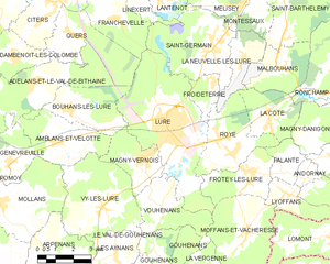
Lure
- commune in Haute-Saône, France
- Country:
- Postal Code: 70200
- Coordinates: 47° 40' 59" N, 6° 29' 48" E
- GPS tracks (wikiloc): [Link]
- Area: 24.31 sq km
- Population: 8253
- Web site: [Link]

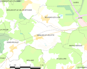
Amblans-et-Velotte
- commune in Haute-Saône, France
- Country:
- Postal Code: 70200
- Coordinates: 47° 40' 46" N, 6° 24' 35" E
- GPS tracks (wikiloc): [Link]
- Area: 9.76 sq km
- Population: 389
- Web site: [Link]

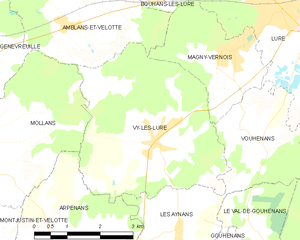
Vy-lès-Lure
- commune in Haute-Saône, France
- Country:
- Postal Code: 70200
- Coordinates: 47° 38' 51" N, 6° 26' 49" E
- GPS tracks (wikiloc): [Link]
- Area: 16 sq km
- Population: 665
- Web site: [Link]


Bouhans-lès-Lure
- commune in Haute-Saône, France
- Country:
- Postal Code: 70200
- Coordinates: 47° 41' 41" N, 6° 25' 22" E
- GPS tracks (wikiloc): [Link]
- Area: 9.11 sq km
- Population: 324


Vouhenans
- commune in Haute-Saône, France
- Country:
- Postal Code: 70200
- Coordinates: 47° 39' 3" N, 6° 28' 53" E
- GPS tracks (wikiloc): [Link]
- Area: 8.36 sq km
- Population: 361