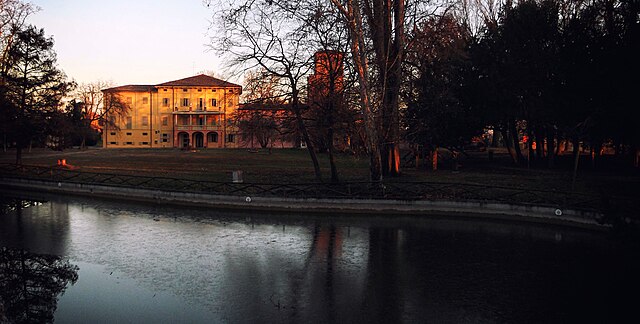
Malalbergo (Malalbergo)
.svg)
- Italian comune
 Hiking in Malalbergo
Malalbergo, located in the Emilia-Romagna region of Italy, offers various hiking opportunities that showcase its beautiful landscapes, historic sites, and charming villages. While the area may not be as famous for hiking as some of Italy's larger national parks, it provides unique trails that appeal to outdoor enthusiasts.
Key Features of Hiking in Malalbergo:
-
Scenic Trails: The area around Malalbergo includes gentle hills, agricultural fields, and picturesque views. You'll find trails suitable for various skill levels, from easy walks to more challenging routes.
-
Rural Charm: Hiking in Malalbergo allows you to explore rural Italy, passing through small towns and farms, where you can experience local culture and perhaps even sample regional cuisine.
-
Historical Points of Interest: Along the trails, you may encounter historical landmarks, such as old churches, ruins, and traditional stone walls, which tell the story of the region's history.
-
Flora and Fauna: The surrounding countryside is rich in biodiversity. You might spot various local wildlife and enjoy the diverse plant life, especially during spring and fall.
-
Accessibility: Malalbergo is easily accessible from major cities like Bologna, making it a convenient destination for day hikes or weekend excursions.
Recommended Hiking Tips:
- Local Maps and Guides: Before heading out, obtain a local hiking map or guide to ensure you stay on established trails and discover hidden gems.
- Timing Your Hike: The best times to hike are in the spring and fall when the weather is mild. Summer can become quite hot, while winter may present snow or icy conditions.
- Stay Hydrated and Prepared: Bring enough water and snacks, wear proper hiking boots, and dress in layers to adapt to changing weather conditions.
- Respect Nature: Follow Leave No Trace principles to help preserve the natural beauty of the area.
Conclusion:
Hiking in Malalbergo offers a delightful experience for those looking to explore Italy's rural landscapes and rich cultural heritage. Whether you're interested in leisurely walks or more vigorous hikes, you'll find plenty to enjoy in this charming part of Emilia-Romagna.
- Country:

- Postal Code: 40051
- Local Dialing Code: 051
- Licence Plate Code: BO
- Coordinates: 44° 43' 10" N, 11° 31' 59" E


- GPS tracks (wikiloc): [Link]
- AboveSeaLevel: 12 м m
- Area: 53.82 sq km
- Population: 9087
- Web site: http://www.comune.malalbergo.bo.it/
- Wikipedia en: wiki(en)
- Wikipedia: wiki(it)
- Wikidata storage: Wikidata: Q94935
- Wikipedia Commons Category: [Link]
- Freebase ID: [/m/0gkhm1]
- GeoNames ID: Alt: [6536740]
- VIAF ID: Alt: [242337678]
- OSM relation ID: [43430]
- GND ID: Alt: [7679246-8]
- MusicBrainz area ID: [c2285697-92a4-468e-a17b-0e9971411ef6]
- WOEID: [717699]
- TGN ID: [1045191]
- ISTAT ID: 037035
- Italian cadastre code: E844
Shares border with regions:


Baricella
- Italian comune
Hiking in Baricella
Baricella is a small town located in the province of Bologna in the Emilia-Romagna region of Italy. While it may not be as widely recognized for hiking as some of the larger national parks or mountainous regions, it offers some charming paths and routes for those looking to enjoy nature....
- Country:
- Postal Code: 40052
- Local Dialing Code: 051
- Licence Plate Code: BO
- Coordinates: 44° 38' 51" N, 11° 32' 7" E
- GPS tracks (wikiloc): [Link]
- AboveSeaLevel: 11 м m
- Area: 45.48 sq km
- Population: 7030
- Web site: [Link]

Bentivoglio
- Italian comune
Hiking in Bentivoglio
Bentivoglio, located in the Emilia-Romagna region of Italy, is a small town known for its historical significance and agricultural surroundings. While it may not be a well-known hiking destination like some of the larger national parks or mountain areas in Italy, there are still opportunities for hiking and exploring the beautiful Emilian countryside....
- Country:
- Postal Code: 40010
- Local Dialing Code: 051
- Licence Plate Code: BO
- Coordinates: 44° 38' 7" N, 11° 25' 8" E
- GPS tracks (wikiloc): [Link]
- AboveSeaLevel: 19 м m
- Area: 51.14 sq km
- Population: 5513
- Web site: [Link]
Galliera
- Italian comune
Hiking in Galliera
Galliera is a municipality located in the Emilia-Romagna region of northern Italy, near Bologna. While it's not widely recognized as a major hiking destination, the surrounding areas offer beautiful landscapes, fields, and trails that can be appealing to hikers looking for a more regional experience....
- Country:
- Postal Code: 40015
- Local Dialing Code: 051
- Licence Plate Code: BO
- Coordinates: 44° 45' 0" N, 11° 24' 0" E
- GPS tracks (wikiloc): [Link]
- AboveSeaLevel: 14 м m
- Area: 37.16 sq km
- Population: 5451
- Web site: [Link]


Minerbio
- Italian comune
Hiking in Minerbio
Minerbio is a small town located in the Emilia-Romagna region of Italy, situated just northeast of the city of Bologna. While Minerbio itself is not widely known for extensive hiking trails or major outdoor activities, the surrounding countryside offers some pleasant opportunities for walking and exploring the natural landscape....
- Country:
- Postal Code: 40061
- Local Dialing Code: 051
- Licence Plate Code: BO
- Coordinates: 44° 37' 3" N, 11° 28' 18" E
- GPS tracks (wikiloc): [Link]
- AboveSeaLevel: 16 м m
- Area: 43.07 sq km
- Population: 8760
- Web site: [Link]


San Pietro in Casale
- Italian comune
Hiking in San Pietro in Casale
San Pietro in Casale is a charming town located in the Emilia-Romagna region of Italy, surrounded by beautiful landscapes that offer some great opportunities for hiking and outdoor activities. While the town itself may not be a well-known hiking destination, its proximity to the Po Valley and the surrounding countryside provides various trails and paths for nature lovers and hikers....
- Country:
- Postal Code: 40018
- Local Dialing Code: 051
- Licence Plate Code: BO
- Coordinates: 44° 42' 0" N, 11° 24' 0" E
- GPS tracks (wikiloc): [Link]
- AboveSeaLevel: 17 м m
- Area: 65.86 sq km
- Population: 12418
- Web site: [Link]
Poggio Renatico
- Italian comune
Hiking in Poggio Renatico
Poggio Renatico is a small municipality located in the Emilia-Romagna region of Italy. While it may not be known as a major hiking destination compared to some of Italy’s more famous areas, it still offers opportunities for nature walks and hiking, especially for those who enjoy exploring lesser-known paths and experiencing the local countryside....
- Country:
- Postal Code: 44028
- Local Dialing Code: 0532
- Licence Plate Code: FE
- Coordinates: 44° 45' 54" N, 11° 29' 0" E
- GPS tracks (wikiloc): [Link]
- AboveSeaLevel: 10 м m
- Area: 80.23 sq km
- Population: 9791
- Web site: [Link]