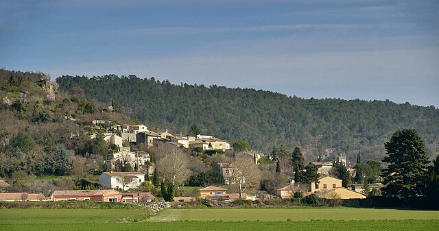
Manas (Manas)

- commune in Drôme, France
 Hiking in Manas
Manas, located in the Drôme department of the Auvergne-Rhône-Alpes region of southeastern France, offers a charming backdrop for hiking enthusiasts. The area is characterized by its beautiful landscapes, rolling hills, vineyards, and proximity to the picturesque landscapes of the Vercors Regional Natural Park and the Drôme Provençale.
Hiking Highlights in Manas and Surrounding Areas:
-
Diverse Trails: The region features a variety of trails suitable for all skill levels. You can find easy walks through vineyards and fields or more challenging hikes that take you into the nearby hills and mountains.
-
Vercors Regional Natural Park: Just a short drive from Manas, the Vercors offers spectacular hiking opportunities, with stunning views, rocky outcrops, and diverse flora and fauna. Popular trails include those leading to the spectacular belvederes overlooking the valley.
-
Countryside Exploration: The area around Manas is ideal for leisurely hikes through charming villages and farmsteads. You can often discover local produce along the way, including olives, lavender, and honey.
-
Natural Springs and Waterfalls: Some trails in the region will lead you to beautiful natural springs and waterfalls, providing perfect spots for rest and picnic opportunities.
-
Historical Sites: Many hiking routes are in proximity to historical sites and monuments, such as old churches and castles, allowing hikers to immerse themselves in the rich history of the region.
Tips for Hiking in Manas:
-
Weather: Always check the local weather conditions before heading out, as the weather can change quickly in mountainous regions.
-
Gear: Wear comfortable hiking boots and carry plenty of water, snacks, and a map or GPS device for navigation.
-
Respect Nature: Follow Leave No Trace principles, respect wildlife, and stay on marked trails to preserve the natural environment.
-
Local Guides: If you’re unfamiliar with the area or prefer exploring with an expert, consider hiring a local guide who can enhance your experience with insights into the landscape and history.
Whether you’re looking for a quick day hike or an extended trek through stunning scenery, Manas in the Drôme department provides a delightful escape into nature. Enjoy your hiking adventures!
- Country:

- Postal Code: 26160
- Coordinates: 44° 35' 58" N, 4° 59' 3" E


- GPS tracks (wikiloc): [Link]
- Area: 1.91 sq km
- Population: 192
- Wikipedia en: wiki(en)
- Wikipedia: wiki(fr)
- Wikidata storage: Wikidata: Q1244851
- Wikipedia Commons Category: [Link]
- Freebase ID: [/m/02n164]
- Freebase ID: [/m/02n164]
- GeoNames ID: Alt: [6430116]
- GeoNames ID: Alt: [6430116]
- SIREN number: [212601710]
- SIREN number: [212601710]
- BnF ID: [15253032k]
- BnF ID: [15253032k]
- INSEE municipality code: 26171
- INSEE municipality code: 26171
Shares border with regions:

Puy-Saint-Martin
- commune in Drôme, France
Hiking in Puy-Saint-Martin
Puy-Saint-Martin is a picturesque village located in the Drôme department in southeastern France. It sits in a beautiful region characterized by rolling hills, vineyards, and charming countryside. While it may not be as widely known as some other hiking destinations in France, it offers several opportunities for outdoor activities, including hiking....
- Country:
- Postal Code: 26450
- Coordinates: 44° 37' 42" N, 4° 58' 24" E
- GPS tracks (wikiloc): [Link]
- Area: 11.65 sq km
- Population: 872


Pont-de-Barret
- commune in Drôme, France
Hiking in Pont-de-Barret
Pont-de-Barret is a charming village located in the Drôme department of the Auvergne-Rhône-Alpes region in southeastern France. It is an excellent area for hiking, offering picturesque landscapes, varied terrain, and a blend of natural beauty and cultural heritage....
- Country:
- Postal Code: 26160
- Coordinates: 44° 36' 7" N, 5° 0' 40" E
- GPS tracks (wikiloc): [Link]
- Area: 16.6 sq km
- Population: 671

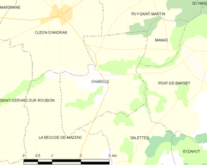
Charols
- commune in Drôme, France
Hiking in Charols
Charols is a charming village located in the Drôme department of the Auvergne-Rhône-Alpes region in southeastern France. It's a great base for hiking enthusiasts due to its picturesque landscapes, diverse terrain, and several trails that cater to various skill levels....
- Country:
- Postal Code: 26450
- Coordinates: 44° 35' 34" N, 4° 57' 5" E
- GPS tracks (wikiloc): [Link]
- Area: 7.31 sq km
- Population: 887