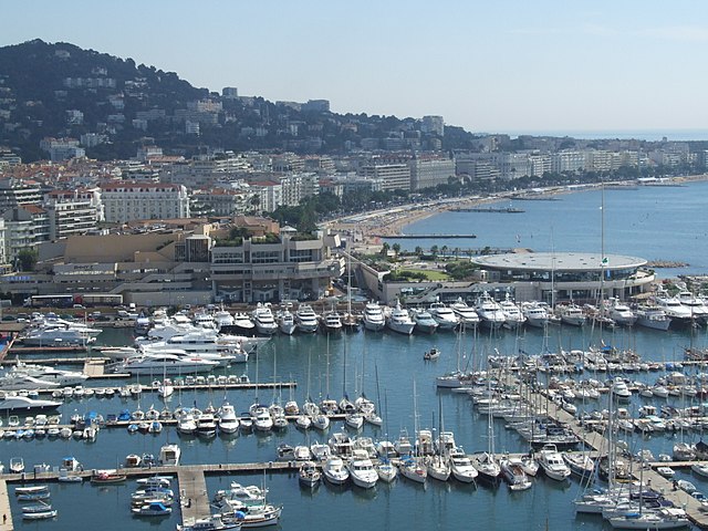
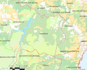
Mandelieu-la-Napoule (Mandelieu-la-Napoule)
- commune in Alpes-Maritimes, France
- Country:

- Postal Code: 06210
- Coordinates: 43° 32' 44" N, 6° 56' 15" E


- GPS tracks (wikiloc): [Link]
- AboveSeaLevel: 300 м m
- Area: 31.37 sq km
- Population: 22360
- Web site: http://www.mandelieu.fr
- Wikipedia en: wiki(en)
- Wikipedia: wiki(fr)
- Wikidata storage: Wikidata: Q239317
- Wikipedia Commons Category: [Link]
- Freebase ID: [/m/0blcj9]
- Freebase ID: [/m/0blcj9]
- GeoNames ID: Alt: [2996255]
- GeoNames ID: Alt: [2996255]
- SIREN number: [210600797]
- SIREN number: [210600797]
- BnF ID: [12177671x]
- BnF ID: [12177671x]
- VIAF ID: Alt: [142810503]
- VIAF ID: Alt: [142810503]
- GND ID: Alt: [4247553-3]
- GND ID: Alt: [4247553-3]
- Library of Congress authority ID: Alt: [n81121710]
- Library of Congress authority ID: Alt: [n81121710]
- PACTOLS thesaurus ID: [pcrtvQBGIKnTfV]
- PACTOLS thesaurus ID: [pcrtvQBGIKnTfV]
- Quora topic ID: [Mandelieu-La-Napoule]
- Quora topic ID: [Mandelieu-La-Napoule]
- SUDOC authorities ID: [030341248]
- SUDOC authorities ID: [030341248]
- YouTube channel ID: [UCsnPW5lfhUxG8t1f-DvIHwA]
- YouTube channel ID: [UCsnPW5lfhUxG8t1f-DvIHwA]
- INSEE municipality code: 06079
- INSEE municipality code: 06079
Shares border with regions:


Fréjus
- commune in Var, France
- Country:

- Postal Code: 83600
- Coordinates: 43° 25' 59" N, 6° 44' 8" E


- GPS tracks (wikiloc): [Link]
- Area: 102.27 sq km
- Population: 52897
- Web site: [Link]


Saint-Raphaël
- commune in Var, France
- Country:

- Postal Code: 83700
- Coordinates: 43° 25' 29" N, 6° 46' 4" E


- GPS tracks (wikiloc): [Link]
- Area: 89.59 sq km
- Population: 35296
- Web site: [Link]

Pégomas
- commune in Alpes-Maritimes, France
Pégomas, a quaint commune located in the Alpes-Maritimes department in the French Riviera, offers a range of hiking opportunities that showcase its beautiful natural surroundings. Here are some key points to consider when hiking in the Pégomas area:...
- Country:

- Postal Code: 06580
- Coordinates: 43° 35' 48" N, 6° 56' 0" E


- GPS tracks (wikiloc): [Link]
- Area: 11.28 sq km
- Population: 7845
- Web site: [Link]

Cannes
- commune in Alpes-Maritimes, France
- Country:

- Postal Code: 06400
- Coordinates: 43° 33' 9" N, 7° 1' 17" E


- GPS tracks (wikiloc): [Link]
- AboveSeaLevel: 0 м m
- Area: 19.62 sq km
- Population: 74285
- Web site: [Link]


Théoule-sur-Mer
- commune in Alpes-Maritimes, France
- Country:

- Postal Code: 06590
- Coordinates: 43° 30' 25" N, 6° 56' 24" E


- GPS tracks (wikiloc): [Link]
- Area: 10.49 sq km
- Population: 1533

La Roquette-sur-Siagne
- commune in Alpes-Maritimes, France
- Country:

- Postal Code: 06550
- Coordinates: 43° 34' 48" N, 6° 57' 20" E


- GPS tracks (wikiloc): [Link]
- Area: 6.31 sq km
- Population: 5435


Tanneron
- commune in Var, France
Tanneron is a picturesque village located in the Alpes-Maritimes department in the Provence-Alpes-Côte d'Azur region of southeastern France. Known for its stunning natural landscapes, the area offers a variety of hiking opportunities that cater to different experience levels....
- Country:

- Postal Code: 83440
- Coordinates: 43° 35' 26" N, 6° 52' 32" E


- GPS tracks (wikiloc): [Link]
- Area: 52.78 sq km
- Population: 1572

