Manthes (Manthes)

- commune in Drôme, France
 Hiking in Manthes
It seems there might be a typo or misunderstanding regarding "Manthes," as it's not a well-known hiking destination based on the common references. However, if you're referring to a specific location that has a different spelling or context, please provide more details.
If you're looking for general hiking information or recommendations for a particular area (such as a national park, region, or country), let me know and I'll be happy to assist!
- Country:

- Postal Code: 26210
- Coordinates: 45° 18' 10" N, 5° 0' 26" E


- GPS tracks (wikiloc): [Link]
- Area: 6.83 sq km
- Population: 668
- Web site: https://manthes.fr/
- Wikipedia en: wiki(en)
- Wikipedia: wiki(fr)
- Wikidata storage: Wikidata: Q1009350
- Wikipedia Commons Category: [Link]
- Freebase ID: [/m/03mhhyp]
- GeoNames ID: Alt: [6430117]
- SIREN number: [212601728]
- BnF ID: [15253033x]
- archINFORM location ID: [12476]
- INSEE municipality code: 26172
Shares border with regions:

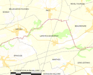
Lapeyrouse-Mornay
- commune in Drôme, France
Hiking in Lapeyrouse-Mornay
Lapeyrouse-Mornay is a charming commune located in the Auvergne-Rhône-Alpes region of France, known for its picturesque landscapes and natural beauty. While it might not be as widely recognized as some of the larger hiking destinations in the region, there are still opportunities for exploring the surrounding countryside....
- Country:
- Postal Code: 26210
- Coordinates: 45° 19' 23" N, 4° 59' 42" E
- GPS tracks (wikiloc): [Link]
- Area: 11.45 sq km
- Population: 1214
- Web site: [Link]

Épinouze
- commune in Drôme, France
Hiking in Épinouze
Épinouze is a charming commune located in the Drôme department of southeastern France. It is surrounded by picturesque landscapes, making it a great spot for hiking enthusiasts. Here are some highlights and tips for hiking in the Épinouze area:...
- Country:
- Postal Code: 26210
- Coordinates: 45° 18' 33" N, 4° 55' 40" E
- GPS tracks (wikiloc): [Link]
- Area: 11.21 sq km
- Population: 1594
- Web site: [Link]


Saint-Sorlin-en-Valloire
- commune in Drôme, France
Hiking in Saint-Sorlin-en-Valloire
Saint-Sorlin-en-Valloire is a picturesque village located in the French Alps, known for its stunning natural beauty and an array of outdoor activities, especially hiking. Here are some highlights and tips for hiking in this beautiful area:...
- Country:
- Postal Code: 26210
- Coordinates: 45° 17' 21" N, 4° 57' 5" E
- GPS tracks (wikiloc): [Link]
- Area: 26.5 sq km
- Population: 2233


Lens-Lestang
- commune in Drôme, France
Hiking in Lens-Lestang
Lens-Lestang is a charming commune located in the Drôme department of southeastern France. It offers a wonderful opportunity for hiking enthusiasts to explore scenic landscapes, picturesque villages, and diverse ecosystems. Here are some key points to consider when planning a hike in and around Lens-Lestang:...
- Country:
- Postal Code: 26210
- Coordinates: 45° 17' 30" N, 5° 2' 33" E
- GPS tracks (wikiloc): [Link]
- Area: 16.41 sq km
- Population: 837
- Web site: [Link]


Moras-en-Valloire
- commune in Drôme, France
Hiking in Moras-en-Valloire
Moras-en-Valloire, located in the Auvergne-Rhône-Alpes region of France, offers a beautiful setting for hiking enthusiasts. The area is known for its picturesque landscapes, rolling hills, and scenic views typical of the Rhône valley....
- Country:
- Postal Code: 26210
- Coordinates: 45° 17' 25" N, 4° 59' 36" E
- GPS tracks (wikiloc): [Link]
- Area: 8.58 sq km
- Population: 646
- Web site: [Link]

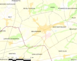
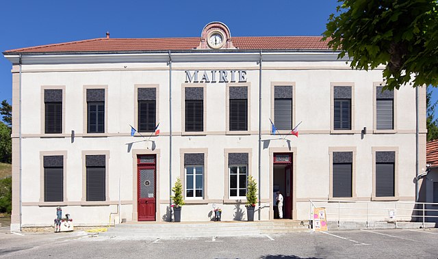
Beaurepaire
- commune in Isère, France
Hiking in Beaurepaire
Beaurepaire, located in the Isère department of France, is a charming commune that offers a variety of hiking opportunities. Nestled in the Rhône-Alpes region, it's surrounded by beautiful landscapes, including rolling hills and valleys, making it a great spot for outdoor enthusiasts....
- Country:
- Postal Code: 38270
- Coordinates: 45° 20' 18" N, 5° 3' 16" E
- GPS tracks (wikiloc): [Link]
- Area: 18.46 sq km
- Population: 4891
- Web site: [Link]