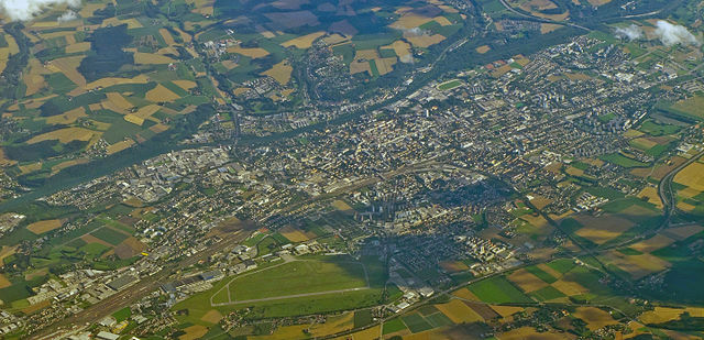
Marchtrenk (Marchtrenk)
- municipality in Austria
 Hiking in Marchtrenk
Marchtrenk, located in Austria, offers a variety of outdoor activities, including hiking. While the area itself may not be as well known for extensive hiking trails as some national parks or mountainous regions, it is surrounded by beautiful landscapes, making it a pleasant destination for walkers and hikers.
Hiking Opportunities in and around Marchtrenk:
-
Local Trails: There are several local walking and hiking trails in and around Marchtrenk. Look for paths that meander through the lush countryside, along rivers, or through nearby woodlands.
-
Waldviertel Region: Just a bit further afield, you can explore the Waldviertel region, known for its rolling hills and picturesque scenery. This area has a network of marked hiking paths suitable for varying fitness levels.
-
Routes for All Levels: You can find shorter, more accessible paths for leisurely walks or longer routes for more experienced hikers. Always check the local trail maps for specifics on distance and difficulty.
-
Scenic Views: The surrounding area provides beautiful views of the Austrian landscape, particularly in the spring when the flowers start to bloom and the greenery returns after winter.
-
Nearby Attractions: You should consider exploring nearby natural attractions, such as the Traun River or the foothills of the Alps, which can offer both hiking challenges and scenic spots for picnicking.
Tips for Hiking in Marchtrenk:
- Weather Awareness: March weather can be unpredictable, so check forecasts before heading out and dress in layers.
- Safety First: Always carry plenty of water, snacks, and a basic first aid kit. Ensure your phone is charged for navigation or if you need to reach someone.
- Trail Regulations: Respect local regulations regarding trail use, including any restrictions that may be in place to protect wildlife and vegetation.
- Hiking Equipment: Depending on the trails, good hiking boots and trekking poles may enhance your experience.
- Guided Hikes: If you're unfamiliar with the area, consider joining a guided hike or consulting with local hiking clubs for recommendations.
Remember to enjoy the natural beauty of Marchtrenk and embrace the physical and mental benefits of hiking!
- Country:

- Postal Code: 4614
- Local Dialing Code: 07243
- Licence Plate Code: WL
- Coordinates: 48° 11' 30" N, 14° 6' 38" E


- GPS tracks (wikiloc): [Link]
- AboveSeaLevel: 304 м m
- Area: 23 sq km
- Population: 13603
- Web site: http://www.marchtrenk.gv.at/
- Wikipedia en: wiki(en)
- Wikipedia: wiki(de)
- Wikidata storage: Wikidata: Q325436
- Wikipedia Commons Category: [Link]
- Freebase ID: [/m/02qhcpb]
- GeoNames ID: Alt: [2771962]
- VIAF ID: Alt: [152564749]
- GND ID: Alt: [4466294-4]
- Library of Congress authority ID: Alt: [n89119044]
- MusicBrainz area ID: [71cb31df-3a6e-4fc0-b208-01a57658647d]
- WOEID: [545853]
- Quora topic ID: [Marchtrenk]
- Facebook Places ID: [108211125874023]
- Austrian municipality key: [41812]
Shares border with regions:
Wels
- city in Upper Austria
Hiking in Wels
Wels, located in Austria, is not typically known as a major hiking destination, but there are several nearby areas and trails that can offer enjoyable hiking experiences. Here are some key points about hiking around Wels:...
- Country:
- Local Dialing Code: 07242
- Licence Plate Code: WE
- Coordinates: 48° 9' 0" N, 14° 1' 0" E
- GPS tracks (wikiloc): [Link]
- AboveSeaLevel: 317 м m
- Area: 45.92 sq km
- Population: 61233
- Web site: [Link]

Oftering
- municipality in Austria
Hiking in Oftering
Oftering, located in the Upper Austria region, offers beautiful landscapes and a variety of hiking opportunities for outdoor enthusiasts. The area is characterized by rolling hills, lush forests, and scenic views, making it a perfect destination for both casual hikers and those looking for more challenging routes....
- Country:
- Postal Code: 4064
- Local Dialing Code: 07221
- Licence Plate Code: LL
- Coordinates: 48° 14' 1" N, 14° 8' 0" E
- GPS tracks (wikiloc): [Link]
- AboveSeaLevel: 316 м m
- Area: 13.50 sq km
- Population: 2076
- Web site: [Link]

Hörsching
- municipality in Austria
Hiking in Hörsching
Hörsching, located in Upper Austria near Linz, offers various opportunities for hiking enthusiasts. While Hörsching itself may not have extensive hiking trails within its immediate vicinity, its location provides easy access to beautiful surrounding areas....
- Country:
- Postal Code: 4063
- Local Dialing Code: 07221
- Licence Plate Code: LL
- Coordinates: 48° 13' 36" N, 14° 10' 46" E
- GPS tracks (wikiloc): [Link]
- AboveSeaLevel: 294 м m
- Area: 20 sq km
- Population: 6062
- Web site: [Link]

Holzhausen
- municipality in Austria
Hiking in Holzhausen
Holzhausen, a charming village in Austria, offers a variety of beautiful hiking trails that cater to different experience levels. The area is surrounded by stunning natural landscapes, mountains, and forests, making it a perfect destination for outdoor enthusiasts. Here are some highlights of hiking in Holzhausen:...
- Country:
- Postal Code: 4615
- Local Dialing Code: 0 72 43
- Licence Plate Code: WL
- Coordinates: 48° 13' 23" N, 14° 5' 56" E
- GPS tracks (wikiloc): [Link]
- AboveSeaLevel: 329 м m
- Area: 8 sq km
- Population: 995
Schleißheim
- municipality in Austria
Hiking in Schleißheim
Schleißheim is a picturesque area located in Bavaria, Germany, not far from Munich. It offers a variety of hiking opportunities that cater to different skill levels....
- Country:
- Postal Code: 4600
- Local Dialing Code: 0 72 42
- Licence Plate Code: WL
- Coordinates: 48° 9' 39" N, 14° 5' 36" E
- GPS tracks (wikiloc): [Link]
- AboveSeaLevel: 317 м m
- Area: 7.55 sq km
- Population: 1389
- Web site: [Link]

Weißkirchen an der Traun
- municipality in Austria
Hiking in Weißkirchen an der Traun
Weißkirchen an der Traun is a picturesque village located in Upper Austria, near the Traun River. The area is known for its beautiful natural scenery and offers various hiking opportunities suitable for different skill levels. Here are some highlights and tips for hiking in this region:...
- Country:
- Postal Code: 4616
- Local Dialing Code: 07243
- Licence Plate Code: WL
- Coordinates: 48° 9' 53" N, 14° 7' 42" E
- GPS tracks (wikiloc): [Link]
- AboveSeaLevel: 305 м m
- Area: 22 sq km
- Population: 3430
- Web site: [Link]
Buchkirchen
- municipality in Austria
Hiking in Buchkirchen
Buchkirchen, a small municipality in Austria, is surrounded by picturesque landscapes that offer plenty of opportunities for hiking enthusiasts. The region boasts a mix of natural beauty, including forests, hills, and scenic views, making it an appealing destination for hikers of all skill levels....
- Country:
- Postal Code: 4611
- Licence Plate Code: WL
- Coordinates: 48° 13' 26" N, 14° 1' 12" E
- GPS tracks (wikiloc): [Link]
- AboveSeaLevel: 346 м m
- Area: 32 sq km
- Population: 4038
- Web site: [Link]