Schleißheim (Schleißheim)
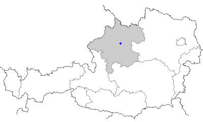
- municipality in Austria
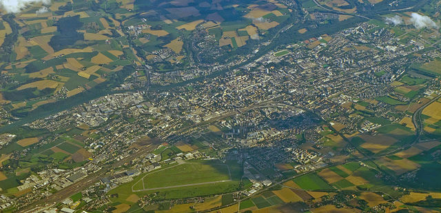
Schleißheim is a picturesque area located in Bavaria, Germany, not far from Munich. It offers a variety of hiking opportunities that cater to different skill levels.
Hiking Trails:
-
Oberschleißheim Park Trails: The area is known for its beautiful parks, including the Schlosspark Schleißheim. Here, you can enjoy easy walking trails that wind through well-maintained gardens and along the serene waterways.
-
Surrounding Countryside: Beyond the parks, there are numerous well-marked hiking trails that lead through the Bavarian countryside, featuring gentle rolling hills, lush green fields, and charming villages.
-
Isar River Trails: A bit farther out, but still accessible from Schleißheim, the trails along the Isar River provide scenic views and are perfect for those looking for a longer hike.
Tips for Hiking in Schleißheim:
- Weather: Always check the weather forecast before heading out, as conditions can change quickly, especially in the spring and autumn.
- Gear: Wear comfortable hiking shoes and bring layers, as temperatures can vary throughout the day.
- Hydration and Snacks: Carry enough water and snacks to keep your energy up during your hike.
- Local Wildlife: Be respectful of nature and wildlife; it’s possible to see a variety of birds and small animals in the area.
Best Time to Hike:
Spring and early autumn are ideal for hiking in Schleißheim due to mild temperatures and beautiful scenery. Summer can be warm but is also vibrant with lush greenery.
Access:
Schleißheim is easily accessible by public transport from Munich, making it a convenient option for a day hike.
Conclusion:
Whether you're an experienced hiker or just looking for a leisurely stroll, Schleißheim has something to offer. Enjoy the natural beauty and historical sights as you explore this charming part of Bavaria!
- Country:

- Postal Code: 4600
- Local Dialing Code: 0 72 42
- Licence Plate Code: WL
- Coordinates: 48° 9' 39" N, 14° 5' 36" E


- GPS tracks (wikiloc): [Link]
- AboveSeaLevel: 317 м m
- Area: 7.55 sq km
- Population: 1389
- Web site: http://www.schleissheim.at/
- Wikipedia en: wiki(en)
- Wikipedia: wiki(de)
- Wikidata storage: Wikidata: Q678337
- Wikipedia Commons Category: [Link]
- Freebase ID: [/m/0d0j0s]
- GeoNames ID: Alt: [7873279]
- VIAF ID: Alt: [237074453]
- archINFORM location ID: [10541]
- Austrian municipality key: [41818]
Shares border with regions:


Wels
- city in Upper Austria
Wels, located in Austria, is not typically known as a major hiking destination, but there are several nearby areas and trails that can offer enjoyable hiking experiences. Here are some key points about hiking around Wels:...
- Country:

- Local Dialing Code: 07242
- Licence Plate Code: WE
- Coordinates: 48° 9' 0" N, 14° 1' 0" E


- GPS tracks (wikiloc): [Link]
- AboveSeaLevel: 317 м m
- Area: 45.92 sq km
- Population: 61233
- Web site: [Link]

Marchtrenk
- municipality in Austria
Marchtrenk, located in Austria, offers a variety of outdoor activities, including hiking. While the area itself may not be as well known for extensive hiking trails as some national parks or mountainous regions, it is surrounded by beautiful landscapes, making it a pleasant destination for walkers and hikers....
- Country:

- Postal Code: 4614
- Local Dialing Code: 07243
- Licence Plate Code: WL
- Coordinates: 48° 11' 30" N, 14° 6' 38" E


- GPS tracks (wikiloc): [Link]
- AboveSeaLevel: 304 м m
- Area: 23 sq km
- Population: 13603
- Web site: [Link]

Sipbachzell
- municipality in Austria
Sipbachzell is a lovely area in Austria that offers a range of hiking opportunities, showcasing the picturesque countryside and natural beauty of the region. Here are some key points to consider if you're planning a hike in and around Sipbachzell:...
- Country:

- Postal Code: 4621
- Local Dialing Code: 07240
- Licence Plate Code: WL
- Coordinates: 48° 5' 53" N, 14° 6' 36" E


- GPS tracks (wikiloc): [Link]
- AboveSeaLevel: 366 м m
- Area: 25 sq km
- Population: 1975
- Web site: [Link]

Thalheim bei Wels
- municipality in Austria
Thalheim bei Wels is a charming village in the Upper Austria region, known for its beautiful landscapes which are great for hiking enthusiasts. Here are some aspects you might find interesting about hiking in this area:...
- Country:

- Postal Code: 4600
- Local Dialing Code: 07242
- Licence Plate Code: WL
- Coordinates: 48° 9' 5" N, 14° 2' 18" E


- GPS tracks (wikiloc): [Link]
- AboveSeaLevel: 369 м m
- Area: 16 sq km
- Population: 5482
- Web site: [Link]

Weißkirchen an der Traun
- municipality in Austria
 Hiking in Weißkirchen an der Traun
Weißkirchen an der Traun is a picturesque village located in Upper Austria, near the Traun River. The area is known for its beautiful natural scenery and offers various hiking opportunities suitable for different skill levels. Here are some highlights and tips for hiking in this region:...
- Country:

- Postal Code: 4616
- Local Dialing Code: 07243
- Licence Plate Code: WL
- Coordinates: 48° 9' 53" N, 14° 7' 42" E


- GPS tracks (wikiloc): [Link]
- AboveSeaLevel: 305 м m
- Area: 22 sq km
- Population: 3430
- Web site: [Link]