Marcollin (Marcollin)

- commune in Isère, France
 Hiking in Marcollin
Marcollin is a charming commune in the Isère department of southeastern France, nestled at the foothills of the Alps. While it may not be as widely recognized as other hiking destinations, it offers beautiful landscapes, scenic views, and a variety of trails that cater to different skill levels.
Hiking Opportunities:
-
Local Trails: The area around Marcollin provides several local hiking trails ranging from easy walks to more challenging hikes. You can explore paths that meander through forests, fields, and hills, offering beautiful views of the surrounding countryside.
-
The Chartreuse Mountains: Just a short drive away are the Chartreuse Mountains, a fantastic area for hiking. Trails in this national park offer stunning vistas, striking limestone formations, and a variety of flora and fauna. There’s plenty of information available for marked trails that vary in difficulty.
-
Topography and Flora: As you hike, you'll encounter lush forests, rivers, and a variety of wildlife. Spring and summer are particularly beautiful, with wildflowers blooming and wildlife active.
Tips for Hiking in Marcollin:
- Trail Maps: Make sure to have a detailed map of the trails. Local tourist information centers may provide maps and additional resources.
- Footwear: Wear sturdy hiking boots, as some trails can be rocky or uneven.
- Weather Preparedness: The weather can change quickly in mountainous areas, so dress in layers and carry rain gear.
- Respect Nature: Always follow the Leave No Trace principles to protect the environment.
Additional Activities:
- Photography: The landscape is perfect for photography, especially during sunrise or sunset.
- Cultural Sites: Take some time to explore nearby villages and cultural sites for a taste of local history and cuisine.
- Other Outdoor Activities: Beyond hiking, consider biking or exploring lakes for swimming or other water-based activities.
Overall, Marcollin may not be a mainstream hiking destination, but it offers a lovely experience for those looking to explore the great outdoors in a serene environment.
- Country:

- Postal Code: 38270
- Coordinates: 45° 18' 20" N, 5° 5' 16" E


- GPS tracks (wikiloc): [Link]
- Area: 10.69 sq km
- Population: 661
- Web site: http://www.marcollin.fr
- Wikipedia en: wiki(en)
- Wikipedia: wiki(fr)
- Wikidata storage: Wikidata: Q1075830
- Wikipedia Commons Category: [Link]
- Freebase ID: [/m/03nvhx6]
- GeoNames ID: Alt: [6433233]
- SIREN number: [213802192]
- BnF ID: [15258034g]
- INSEE municipality code: 38219
Shares border with regions:


Lentiol
- commune in Isère, France
Hiking in Lentiol
Lentiol, a beautiful area in the French Alps, is a fantastic destination for hiking enthusiasts. Here are a few key points about hiking in Lentiol:...
- Country:
- Postal Code: 38270
- Coordinates: 45° 17' 57" N, 5° 6' 48" E
- GPS tracks (wikiloc): [Link]
- Area: 7.6 sq km
- Population: 217
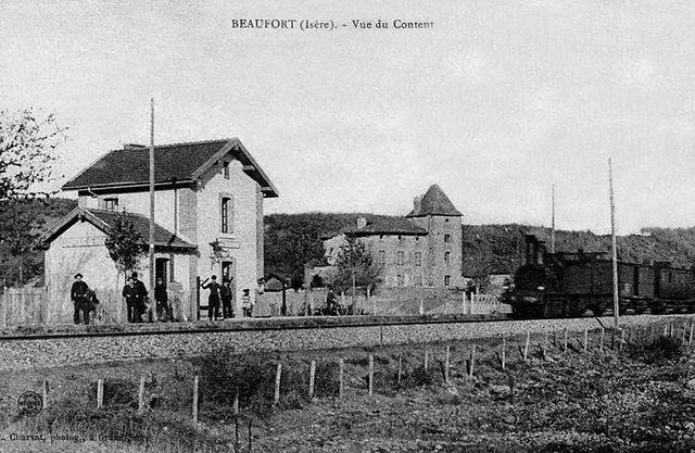

Beaufort
- commune in Isère, France
Hiking in Beaufort
Beaufort, located in the Isère department of the Auvergne-Rhône-Alpes region in southeastern France, is a charming area known for its stunning alpine scenery and diverse hiking opportunities. Here are some highlights about hiking in this region:...
- Country:
- Postal Code: 38270
- Coordinates: 45° 19' 35" N, 5° 7' 19" E
- GPS tracks (wikiloc): [Link]
- AboveSeaLevel: 280 м m
- Area: 8.69 sq km
- Population: 564


Lens-Lestang
- commune in Drôme, France
Hiking in Lens-Lestang
Lens-Lestang is a charming commune located in the Drôme department of southeastern France. It offers a wonderful opportunity for hiking enthusiasts to explore scenic landscapes, picturesque villages, and diverse ecosystems. Here are some key points to consider when planning a hike in and around Lens-Lestang:...
- Country:
- Postal Code: 26210
- Coordinates: 45° 17' 30" N, 5° 2' 33" E
- GPS tracks (wikiloc): [Link]
- Area: 16.41 sq km
- Population: 837
- Web site: [Link]


Saint-Barthélemy
- commune in Isère, France
Hiking in Saint-Barthélemy
Saint-Barthélemy is a beautiful commune in the Isère department of the Auvergne-Rhône-Alpes region in southeastern France. Known for its picturesque landscapes, hiking in this area can vary from gentle strolls to more challenging hikes that reward adventurers with stunning views of the surrounding Alps and valleys....
- Country:
- Postal Code: 38270
- Coordinates: 45° 20' 47" N, 5° 4' 49" E
- GPS tracks (wikiloc): [Link]
- Area: 7.98 sq km
- Population: 962
- Web site: [Link]

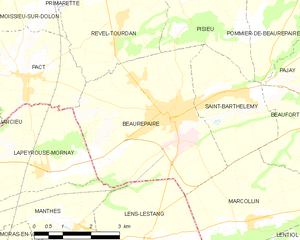
Beaurepaire
- commune in Isère, France
Hiking in Beaurepaire
Beaurepaire, located in the Isère department of France, is a charming commune that offers a variety of hiking opportunities. Nestled in the Rhône-Alpes region, it's surrounded by beautiful landscapes, including rolling hills and valleys, making it a great spot for outdoor enthusiasts....
- Country:
- Postal Code: 38270
- Coordinates: 45° 20' 18" N, 5° 3' 16" E
- GPS tracks (wikiloc): [Link]
- Area: 18.46 sq km
- Population: 4891
- Web site: [Link]