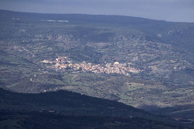
Marrubiu (Marrubiu)
%20-%202016.svg)
- Italian comune
 Hiking in Marrubiu
Marrubiu is a small town located in the province of Oristano on the island of Sardinia, Italy. While it may not be one of the most famous hiking destinations on the island, it does offer some beautiful natural landscapes and opportunities for outdoor activities that can appeal to hikers.
Hiking Opportunities in and around Marrubiu
-
Scenic Trails: The areas surrounding Marrubiu feature a mix of coastal landscapes, rolling hills, and lush countryside. You can find trails that provide stunning views of the Mediterranean landscape, especially if you venture towards the nearby coast.
-
Natural Parks: The nearby Sinis Peninsula, which includes the Sinis-Montiferru Protected Area, offers a range of hiking opportunities. This area is known for its unique geological formations, archaeological sites, and a rich diversity of flora and fauna.
-
Archaeological Points of Interest: If you're interested in both hiking and history, look for trails near ancient sites such as the ruins of the Phoenician city of Tharros. Exploring these historical landmarks adds an extra layer of intrigue to your hiking adventures.
-
Wildlife Watching: The diverse ecosystems in the region mean that it's also a great spot for birdwatching and spotting other wildlife. Bring your binoculars for a chance to see various birds and potentially some of the local fauna.
Tips for Hiking in Marrubiu
-
Prepare for the Climate: Sardinia can be warm, especially in the summer months. Plan your hikes during the cooler parts of the day, typically early morning or late afternoon. Always bring plenty of water to stay hydrated!
-
Footwear and Gear: Good hiking shoes are essential, especially when navigating uneven terrain. Depending on the season, consider wearing sun protection such as hats or sunscreen and clothing that offers good ventilation.
-
Local Guides: It may be beneficial to consider hiring a local guide or joining a hiking tour to learn more about the area’s natural and cultural heritage while ensuring you stay on established trails.
-
Map and GPS: While some trails might be easy to navigate, it's always a good idea to carry a map or use a hiking app for GPS to avoid getting lost, especially if you venture into less traveled paths.
-
Respect Nature: Always follow Leave No Trace principles. Respect the natural environment by staying on trails, packing out all your trash, and observing wildlife from a distance.
Hiking in Marrubiu may not be as popular as other locations in Sardinia, but it offers a tranquil experience for hiking enthusiasts looking to explore off the beaten path. Enjoy your adventure!
- Country:

- Postal Code: 09094
- Local Dialing Code: 0783
- Licence Plate Code: OR
- Coordinates: 39° 45' 4" N, 8° 38' 18" E


- GPS tracks (wikiloc): [Link]
- AboveSeaLevel: 7 м m
- Area: 61.24 sq km
- Population: 4819
- Web site: http://www.comune.marrubiu.or.it
- Wikipedia en: wiki(en)
- Wikipedia: wiki(it)
- Wikidata storage: Wikidata: Q386323
- Wikipedia Commons Category: [Link]
- Freebase ID: [/m/0gr0dq]
- GeoNames ID: Alt: [6539361]
- OSM relation ID: [40071]
- TGN ID: [1045279]
- ISTAT ID: 095025
- Italian cadastre code: E972
Shares border with regions:


Ales, Sardinia
- comune of Italy
Hiking in Ales, Sardinia
Ales is a charming town located in the province of Oristano in Sardinia, Italy. Although Ales itself might not be a well-known hiking destination compared to other parts of Sardinia, it serves as a great base for exploring the surrounding landscapes, which offer a variety of hiking opportunities....
- Country:
- Postal Code: 09091
- Local Dialing Code: 0783
- Licence Plate Code: OR
- Coordinates: 39° 46' 0" N, 8° 49' 0" E
- GPS tracks (wikiloc): [Link]
- AboveSeaLevel: 194 м m
- Area: 22.45 sq km
- Population: 1410
- Web site: [Link]


Arborea
- Italian comune
Hiking in Arborea
Arborea is a beautiful area located in Sardinia, Italy. It's known for its stunning natural landscapes, including lush forests, wetlands, and a picturesque coastline. Here are some highlights of hiking in Arborea:...
- Country:
- Postal Code: 09092
- Local Dialing Code: 0783
- Licence Plate Code: OR
- Coordinates: 39° 46' 22" N, 8° 34' 53" E
- GPS tracks (wikiloc): [Link]
- AboveSeaLevel: 7 м m
- Area: 94.96 sq km
- Population: 3906
- Web site: [Link]

Morgongiori
- Italian comune
Hiking in Morgongiori
Morgongiori is a small village located in the province of Oristano in Sardinia, Italy. It’s known for its picturesque landscapes and proximity to the mountainous terrain of the region. Hiking in Morgongiori offers a unique opportunity to explore the natural beauty and cultural heritage of Sardinia....
- Country:
- Postal Code: 09090
- Local Dialing Code: 0783
- Licence Plate Code: OR
- Coordinates: 39° 44' 46" N, 8° 46' 14" E
- GPS tracks (wikiloc): [Link]
- AboveSeaLevel: 351 м m
- Area: 45.2 sq km
- Population: 716
- Web site: [Link]


Santa Giusta
- Italian comune
Hiking in Santa Giusta
Santa Giusta is a charming village located in the Oristano province of Sardinia, Italy. While not as widely known for hiking compared to other regions in Sardinia, it does offer some beautiful landscapes and opportunities for exploration....
- Country:
- Postal Code: 09096
- Local Dialing Code: 0783
- Licence Plate Code: OR
- Coordinates: 39° 52' 51" N, 8° 36' 33" E
- GPS tracks (wikiloc): [Link]
- AboveSeaLevel: 10 м m
- Area: 69.22 sq km
- Population: 4807
- Web site: [Link]


Terralba
- Italian comune
Hiking in Terralba
Terralba is a small town located in the province of Oristano in Sardinia, Italy. The area around Terralba offers a variety of hiking opportunities, characterized by stunning landscapes, rich natural diversity, and historical sites....
- Country:
- Postal Code: 09098
- Local Dialing Code: 0783
- Licence Plate Code: OR
- Coordinates: 39° 43' 11" N, 8° 38' 11" E
- GPS tracks (wikiloc): [Link]
- AboveSeaLevel: 9 м m
- Area: 49.8 sq km
- Population: 10196
- Web site: [Link]


Uras
- Italian comune
Hiking in Uras
Uras is a small town located in the province of Oristano in Sardinia, Italy. While it may not be as famous as some other Italian hiking destinations, it serves as a gateway to exploring the beautiful natural landscapes of Sardinia. The area is characterized by rolling hills, rugged terrain, and picturesque views, making it a great spot for hiking enthusiasts. Here are some aspects to consider if you're planning to hike in and around Uras:...
- Country:
- Postal Code: 09099
- Local Dialing Code: 0783
- Licence Plate Code: OR
- Coordinates: 39° 41' 54" N, 8° 42' 5" E
- GPS tracks (wikiloc): [Link]
- AboveSeaLevel: 23 м m
- Area: 39.24 sq km
- Population: 2825
- Web site: [Link]