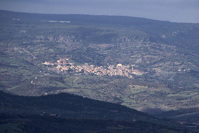
Uras (Uras)
%20-%202016.svg)
- Italian comune
 Hiking in Uras
Uras is a small town located in the province of Oristano in Sardinia, Italy. While it may not be as famous as some other Italian hiking destinations, it serves as a gateway to exploring the beautiful natural landscapes of Sardinia. The area is characterized by rolling hills, rugged terrain, and picturesque views, making it a great spot for hiking enthusiasts. Here are some aspects to consider if you're planning to hike in and around Uras:
Trails and Nature:
-
Natural Landscapes: The area near Uras features diverse landscapes, including hills, forests, and agricultural fields. You can often find trails that offer stunning views of the countryside.
-
Local Parks and Reserves: Nearby natural parks, like Monte Arci Regional Park, provide excellent hiking opportunities with well-marked trails. The park is known for its unique geological formations and biodiversity.
-
Historical Sites: Some hiking routes may lead you to archaeological sites or old ruins, as Sardinia is rich in history. Exploring these sites while hiking can add cultural value to your outdoor experience.
Difficulty Levels:
- Variety of Trails: You'll find a range of trails suitable for different experience levels, from easy walks for beginners to more challenging hikes for seasoned hikers.
Preparation and Safety:
-
Weather Considerations: Always check the weather before heading out, as conditions can change rapidly. The best time for hiking in Sardinia is typically in spring (April to June) and fall (September to October) when temperatures are mild.
-
Supplies: Make sure to carry enough water, snacks, a map or GPS device, and a first-aid kit. It’s also wise to wear sturdy hiking boots and appropriate clothing.
-
Local Guidance: If you're unfamiliar with the area, consider hiring a local guide who can provide insight into the flora and fauna, as well as ensure your safety.
Cultural Experience:
Hiking in Sardinia not only offers stunning natural scenery but also a chance to immerse yourself in local culture. You might encounter traditional villages, local cuisine, and the warm hospitality of the Sardinian people.
Ultimately, hiking in the Uras area can be a rewarding experience, combining physical activity with the beauty of nature and cultural exploration. Enjoy your adventure!
- Country:

- Postal Code: 09099
- Local Dialing Code: 0783
- Licence Plate Code: OR
- Coordinates: 39° 41' 54" N, 8° 42' 5" E


- GPS tracks (wikiloc): [Link]
- AboveSeaLevel: 23 м m
- Area: 39.24 sq km
- Population: 2825
- Web site: http://www.comune.uras.or.it
- Wikipedia en: wiki(en)
- Wikipedia: wiki(it)
- Wikidata storage: Wikidata: Q389339
- Wikipedia Commons Category: [Link]
- Freebase ID: [/m/0gr1cc]
- GeoNames ID: Alt: [6539379]
- VIAF ID: Alt: [132685930]
- OSM relation ID: [40043]
- ISTAT ID: 095069
- Italian cadastre code: L496
Shares border with regions:


Marrubiu
- Italian comune
Hiking in Marrubiu
Marrubiu is a small town located in the province of Oristano on the island of Sardinia, Italy. While it may not be one of the most famous hiking destinations on the island, it does offer some beautiful natural landscapes and opportunities for outdoor activities that can appeal to hikers....
- Country:
- Postal Code: 09094
- Local Dialing Code: 0783
- Licence Plate Code: OR
- Coordinates: 39° 45' 4" N, 8° 38' 18" E
- GPS tracks (wikiloc): [Link]
- AboveSeaLevel: 7 м m
- Area: 61.24 sq km
- Population: 4819
- Web site: [Link]


Masullas
- Italian comune
Hiking in Masullas
Masullas is a charming village located in the province of Oristano in Sardinia, Italy. It's not as well-known as some other hiking destinations, but it offers beautiful landscapes and a unique experience for outdoor enthusiasts....
- Country:
- Postal Code: 09090
- Local Dialing Code: 0783
- Licence Plate Code: OR
- Coordinates: 39° 42' 0" N, 8° 47' 3" E
- GPS tracks (wikiloc): [Link]
- AboveSeaLevel: 129 м m
- Area: 18.68 sq km
- Population: 1061
- Web site: [Link]


Mogoro
- Italian comune
Hiking in Mogoro
Mogoro, located in the Oristano province of Sardinia, Italy, offers a unique hiking experience that combines stunning landscapes, rich cultural heritage, and diverse ecosystems. The region is characterized by beautiful rolling hills, scenic countryside, and proximity to the coast, making it ideal for a variety of outdoor activities....
- Country:
- Postal Code: 09095
- Local Dialing Code: 0783
- Licence Plate Code: OR
- Coordinates: 39° 41' 6" N, 8° 46' 37" E
- GPS tracks (wikiloc): [Link]
- AboveSeaLevel: 186 м m
- Area: 48.99 sq km
- Population: 4118
- Web site: [Link]

Morgongiori
- Italian comune
Hiking in Morgongiori
Morgongiori is a small village located in the province of Oristano in Sardinia, Italy. It’s known for its picturesque landscapes and proximity to the mountainous terrain of the region. Hiking in Morgongiori offers a unique opportunity to explore the natural beauty and cultural heritage of Sardinia....
- Country:
- Postal Code: 09090
- Local Dialing Code: 0783
- Licence Plate Code: OR
- Coordinates: 39° 44' 46" N, 8° 46' 14" E
- GPS tracks (wikiloc): [Link]
- AboveSeaLevel: 351 м m
- Area: 45.2 sq km
- Population: 716
- Web site: [Link]


San Nicolò d'Arcidano
- Italian comune
Hiking in San Nicolò d'Arcidano
San Nicolò d'Arcidano is a charming town located in the province of Oristano, Sardinia, Italy. Surrounded by beautiful landscapes, it offers various opportunities for hiking and exploring the natural beauty of the region....
- Country:
- Postal Code: 09097
- Local Dialing Code: 0783
- Licence Plate Code: OR
- Coordinates: 39° 41' 1" N, 8° 38' 48" E
- GPS tracks (wikiloc): [Link]
- AboveSeaLevel: 13 м m
- Area: 28.36 sq km
- Population: 2630
- Web site: [Link]


Terralba
- Italian comune
Hiking in Terralba
Terralba is a small town located in the province of Oristano in Sardinia, Italy. The area around Terralba offers a variety of hiking opportunities, characterized by stunning landscapes, rich natural diversity, and historical sites....
- Country:
- Postal Code: 09098
- Local Dialing Code: 0783
- Licence Plate Code: OR
- Coordinates: 39° 43' 11" N, 8° 38' 11" E
- GPS tracks (wikiloc): [Link]
- AboveSeaLevel: 9 м m
- Area: 49.8 sq km
- Population: 10196
- Web site: [Link]