Marson-sur-Barboure (Marson-sur-Barboure)

- commune in Meuse, France
- Country:

- Postal Code: 55190
- Coordinates: 48° 38' 29" N, 5° 26' 40" E


- GPS tracks (wikiloc): [Link]
- Area: 5.9 sq km
- Population: 49
- Wikipedia en: wiki(en)
- Wikipedia: wiki(fr)
- Wikidata storage: Wikidata: Q892519
- Wikipedia Commons Category: [Link]
- Freebase ID: [/m/03qds5t]
- GeoNames ID: Alt: [6437094]
- SIREN number: [215503228]
- BnF ID: [15264987s]
- INSEE municipality code: 55322
Shares border with regions:


Boviolles
- commune in Meuse, France
- Country:
- Postal Code: 55500
- Coordinates: 48° 38' 51" N, 5° 25' 3" E
- GPS tracks (wikiloc): [Link]
- Area: 8.13 sq km
- Population: 97


Méligny-le-Petit
- commune in Meuse, France
- Country:
- Postal Code: 55190
- Coordinates: 48° 39' 34" N, 5° 27' 56" E
- GPS tracks (wikiloc): [Link]
- Area: 8.39 sq km
- Population: 83


Tréveray
- commune in Meuse, France
- Country:
- Postal Code: 55130
- Coordinates: 48° 36' 36" N, 5° 23' 52" E
- GPS tracks (wikiloc): [Link]
- Area: 17.18 sq km
- Population: 595


Reffroy
- commune in Meuse, France
- Country:
- Postal Code: 55190
- Coordinates: 48° 37' 53" N, 5° 27' 54" E
- GPS tracks (wikiloc): [Link]
- Area: 9.41 sq km
- Population: 69

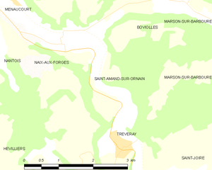
Saint-Amand-sur-Ornain
- commune in Meuse, France
- Country:
- Postal Code: 55500
- Coordinates: 48° 37' 38" N, 5° 23' 13" E
- GPS tracks (wikiloc): [Link]
- Area: 6.06 sq km
- Population: 61