Saint-Amand-sur-Ornain (Saint-Amand-sur-Ornain)

- commune in Meuse, France
- Country:

- Postal Code: 55500
- Coordinates: 48° 37' 38" N, 5° 23' 13" E


- GPS tracks (wikiloc): [Link]
- Area: 6.06 sq km
- Population: 61
- Wikipedia en: wiki(en)
- Wikipedia: wiki(fr)
- Wikidata storage: Wikidata: Q59418
- Wikipedia Commons Category: [Link]
- Freebase ID: [/m/03qdtkr]
- GeoNames ID: Alt: [6437187]
- SIREN number: [215504523]
- BnF ID: [15265117n]
- VIAF ID: Alt: [124404539]
- Library of Congress authority ID: Alt: [n85233977]
- PACTOLS thesaurus ID: [pcrtMDgi0IcHO3]
- INSEE municipality code: 55452
Shares border with regions:


Boviolles
- commune in Meuse, France
- Country:
- Postal Code: 55500
- Coordinates: 48° 38' 51" N, 5° 25' 3" E
- GPS tracks (wikiloc): [Link]
- Area: 8.13 sq km
- Population: 97


Tréveray
- commune in Meuse, France
- Country:
- Postal Code: 55130
- Coordinates: 48° 36' 36" N, 5° 23' 52" E
- GPS tracks (wikiloc): [Link]
- Area: 17.18 sq km
- Population: 595

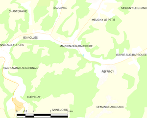
Marson-sur-Barboure
- commune in Meuse, France
- Country:
- Postal Code: 55190
- Coordinates: 48° 38' 29" N, 5° 26' 40" E
- GPS tracks (wikiloc): [Link]
- Area: 5.9 sq km
- Population: 49

Naix-aux-Forges
- commune in Meuse, France
- Country:
- Postal Code: 55500
- Coordinates: 48° 38' 11" N, 5° 22' 37" E
- GPS tracks (wikiloc): [Link]
- Area: 6.32 sq km
- Population: 210