Marzahn-Hellersdorf (Marzahn-Hellersdorf)
- borough of Berlin, Germany
 Hiking in Marzahn-Hellersdorf
Marzahn-Hellersdorf, located in the eastern part of Berlin, is primarily known as a residential district, but it does have some green spaces and parks that can be suitable for short hikes and nature walks. Although it may not offer extensive hiking trails like more rural areas, there are still some places worth exploring:
-
Naherholungsgebiet Marzahn (Recreation Area Marzahn): This is a large green area with walking paths, forested sections, and open spaces. It's perfect for leisurely walks, picnics, and enjoying nature without venturing too far from the city.
-
Gardens of the World (Gärten der Welt): Located within the district, this beautiful park features various themed gardens from different cultures. While it’s more of a stroll than a hike, the diverse landscapes offer a lovely experience for visitors and a chance to connect with nature.
-
Wuhle River Trail: The Wuhle River runs through the Marzahn-Hellersdorf district and offers scenic walkways along the riverbank. Although it's not a traditional hiking trail, walking along the river provides a nice escape into nature.
-
Dolskistraße Nature Reserve: On the edge of Marzahn-Hellersdorf, this area includes wetlands and is home to various species of birds and wildlife. It's a peaceful location for those looking to explore natural habitats.
-
Fitness and Biking Trails: The district offers a network of paths suitable for cycling and jogging, which can also be enjoyed as a walking or hiking experience.
When planning your hike, take into consideration the season, as the experience can vary greatly with the weather. Spring and summer are great for enjoying blooming flowers and lush greenery, while autumn provides beautiful foliage. Always bring enough water, wear appropriate footwear, and follow any local guidelines regarding nature conservation.
- Country:

- Coordinates: 52° 32' 0" N, 13° 35' 0" E


- GPS tracks (wikiloc): [Link]
- Area: 61.74 sq km
- Web site: http://www.berlin.de/ba-marzahn-hellersdorf
- Wikipedia en: wiki(en)
- Wikipedia: wiki(de)
- Wikidata storage: Wikidata: Q119284
- Wikipedia Commons Gallery: [Link]
- Wikipedia Commons Category: [Link]
- Wikipedia Commons Maps Category: [Link]
- Freebase ID: [/m/022nfc]
- GeoNames ID: Alt: [3336296]
- VIAF ID: Alt: [246973700]
- OSM relation ID: [164712]
- GND ID: Alt: [4705061-5]
- archINFORM location ID: [43209]
- Quora topic ID: [Marzahn-Hellersdorf]
- TGN ID: [7032547]
Includes regions:


Mahlsdorf
- locality of Berlin
Hiking in Mahlsdorf
Mahlsdorf is a district located in the eastern part of Berlin, Germany. While not typically known as a hiking destination like some of the more mountainous regions of Germany, it does offer some pleasant walking and hiking opportunities within and around the area....
- Country:
- Postal Code: 12623
- Coordinates: 52° 30' 22" N, 13° 36' 54" E
- GPS tracks (wikiloc): [Link]
- AboveSeaLevel: 53 м m
- Area: 12.94 sq km
- Population: 27504


Kaulsdorf
- locality of Berlin
Hiking in Kaulsdorf
Kaulsdorf is a district in the borough of Marzahn-Hellersdorf in Berlin, and while it may not be as well-known for hiking as some of the natural parks outside the city, there are still opportunities to explore the outdoors in and around the area. Here are some points to consider if you’re looking to hike in or near Kaulsdorf:...
- Country:
- Postal Code: 12619; 12621
- Coordinates: 52° 30' 29" N, 13° 34' 51" E
- GPS tracks (wikiloc): [Link]
- AboveSeaLevel: 55 м m
- Area: 8.81 sq km
- Population: 18656


Biesdorf
- locality of Berlin
Hiking in Biesdorf
Biesdorf is a district located in the eastern part of Berlin, Germany. While it is primarily an urban area, there are still outdoor opportunities for walking and enjoying nature. Here are some highlights for hiking or walking in and around Biesdorf:...
- Country:
- Postal Code: 12683
- Coordinates: 52° 30' 33" N, 13° 33' 19" E
- GPS tracks (wikiloc): [Link]
- AboveSeaLevel: 44 м m
- Area: 12.44 sq km
- Population: 25622

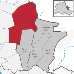
Marzahn
- locality of Berlin
Hiking in Marzahn
Marzahn, a district located in the northeastern part of Berlin, Germany, is not typically known as a hiking destination in the traditional sense, as it is more urbanized compared to other areas. However, there are still opportunities for walking and exploring nature in and around this district....
- Country:
- Postal Code: 12689; 12687; 12685; 12681; 12679
- Coordinates: 52° 32' 45" N, 13° 33' 45" E
- GPS tracks (wikiloc): [Link]
- AboveSeaLevel: 62 м m
- Area: 19.54 sq km
- Population: 106640


Hellersdorf
- locality of Berlin
Hiking in Hellersdorf
Hellersdorf, a district in the eastern part of Berlin, Germany, is not traditionally known for hiking in the way that more rural or mountainous areas are. However, it offers some pleasant routes for walking and exploring nature....
- Country:
- Postal Code: 12683; 12629; 12627; 12619
- Coordinates: 52° 32' 15" N, 13° 36' 15" E
- GPS tracks (wikiloc): [Link]
- AboveSeaLevel: 60 м m
- Area: 8.1 sq km
- Population: 78683
Shares border with regions:

Treptow-Köpenick
- borough of Berlin, Germany
Hiking in Treptow-Köpenick
Treptow-Köpenick, located in the southeastern part of Berlin, is a picturesque district known for its natural beauty and recreational opportunities, making it an excellent area for hiking and enjoying the outdoors....
- Country:
- Coordinates: 52° 27' 0" N, 13° 34' 0" E
- GPS tracks (wikiloc): [Link]
- Area: 168 sq km
- Web site: [Link]

Lichtenberg
- borough of Berlin, Germany
Hiking in Lichtenberg
Lichtenberg is a beautiful region that offers various hiking opportunities, especially notable in both natural beauty and cultural significance. While there are different locations and contexts for Lichtenberg (such as a district in Berlin or other areas named Lichtenberg), I'll focus on general hiking aspects that you might find in such areas....
- Country:
- Coordinates: 52° 32' 0" N, 13° 30' 0" E
- GPS tracks (wikiloc): [Link]
- Area: 52.11 sq km
- Population: 275142
- Web site: [Link]