May-sur-Orne (May-sur-Orne)

- commune in Calvados, France
- Country:

- Postal Code: 14320
- Coordinates: 49° 6' 1" N, 0° 22' 26" E


- GPS tracks (wikiloc): [Link]
- Area: 3.49 sq km
- Population: 1903
- Web site: http://www.may-sur-orne.fr
- Wikipedia en: wiki(en)
- Wikipedia: wiki(fr)
- Wikidata storage: Wikidata: Q217943
- Wikipedia Commons Category: [Link]
- Freebase ID: [/m/030d_w]
- Freebase ID: [/m/030d_w]
- GeoNames ID: Alt: [2994906]
- GeoNames ID: Alt: [2994906]
- SIREN number: [211404082]
- SIREN number: [211404082]
- BnF ID: [152478227]
- BnF ID: [152478227]
- VIAF ID: Alt: [134039458]
- VIAF ID: Alt: [134039458]
- Library of Congress authority ID: Alt: [no2003101638]
- Library of Congress authority ID: Alt: [no2003101638]
- PACTOLS thesaurus ID: [pcrtU7YasNs7Oj]
- PACTOLS thesaurus ID: [pcrtU7YasNs7Oj]
- INSEE municipality code: 14408
- INSEE municipality code: 14408
Shares border with regions:


Laize-la-Ville
- former commune in Calvados, France
- Country:
- Postal Code: 14320
- Coordinates: 49° 4' 56" N, 0° 22' 52" E
- GPS tracks (wikiloc): [Link]
- Area: 1.76 sq km
- Population: 760


Clinchamps-sur-Orne
- former commune in Calvados, France
- Country:
- Postal Code: 14320
- Coordinates: 49° 4' 48" N, 0° 24' 3" E
- GPS tracks (wikiloc): [Link]
- Area: 6.37 sq km
- Population: 1163


Saint-André-sur-Orne
- commune in Calvados, France
- Country:
- Postal Code: 14320
- Coordinates: 49° 7' 6" N, 0° 22' 59" E
- GPS tracks (wikiloc): [Link]
- Area: 3.68 sq km
- Population: 1802
- Web site: [Link]

Saint-Martin-de-Fontenay
- commune in Calvados, France
- Country:
- Postal Code: 14320
- Coordinates: 49° 7' 9" N, 0° 22' 16" E
- GPS tracks (wikiloc): [Link]
- Area: 10.72 sq km
- Population: 2594
- Web site: [Link]


Feuguerolles-Bully
- commune in Calvados, France
- Country:
- Postal Code: 14320
- Coordinates: 49° 7' 1" N, 0° 24' 26" E
- GPS tracks (wikiloc): [Link]
- AboveSeaLevel: 90 м m
- Area: 8.18 sq km
- Population: 1418
- Web site: [Link]

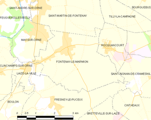
Fontenay-le-Marmion
- commune in Calvados, France
- Country:
- Postal Code: 14320
- Coordinates: 49° 5' 36" N, 0° 21' 11" E
- GPS tracks (wikiloc): [Link]
- Area: 10.16 sq km
- Population: 1887