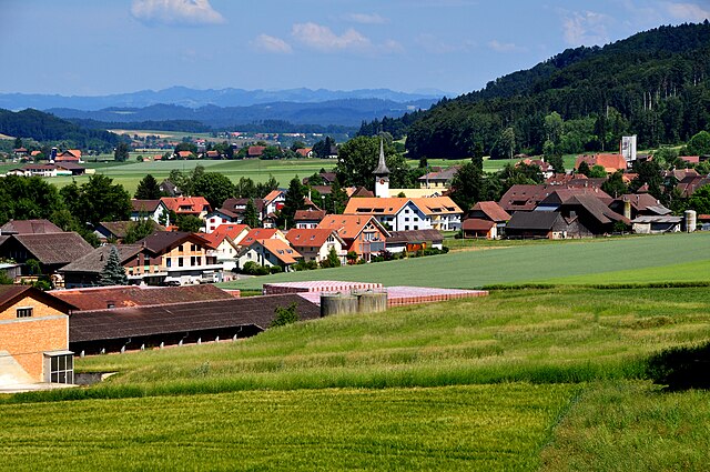
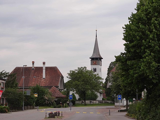
Meikirch (Meikirch)

- municipality in Switzerland
 Hiking in Meikirch
Meikirch, located in the Canton of Bern, Switzerland, offers a lovely setting for hiking enthusiasts. Surrounded by picturesque landscapes, rolling hills, and scenic views, it serves as a great starting point for various hiking trails.
Popular Hiking Routes:
-
Meikirch to Wabern: This moderate hike takes you through charming rural landscapes, allowing you to experience the local flora and fauna.
-
Hiking towards Gurten: You can take trails that lead towards the Gurten, a local mountain, which provides panoramic views of the Bernese Alps and the city of Bern.
-
Bäri-Rundweg: A circular trail that showcases the natural beauty of the area while passing through forests and meadows, making it suitable for families.
Best Times to Hike:
The ideal months for hiking in Meikirch are typically late spring (May and June) through early autumn (September and October). During these times, the weather is generally mild, and the scenery is vibrant.
Tips for Hikers:
- Preparation: Always check the weather forecast and trail conditions before heading out.
- Trail Map: While trails are often well-marked, having a map or a hiking app handy can be helpful for navigation.
- Safety: Carry enough water, snacks, and a first-aid kit. Inform someone about your hiking route and estimated return time.
Local Attractions:
Aside from hiking, Meikirch features charming local spots to explore, including farms and quaint villages. It’s also worth visiting the nearby city of Bern for additional cultural experiences.
Hiking in Meikirch offers a unique combination of natural beauty and cultural richness, making it a fantastic destination for both beginners and seasoned hikers. Enjoy your adventure!
- Country:

- Postal Code: 3042, 3045, 3046
- Local Dialing Code: 031
- Licence Plate Code: BE
- Coordinates: 47° 0' 35" N, 7° 21' 55" E


- GPS tracks (wikiloc): [Link]
- AboveSeaLevel: 654 м m
- Area: 10.30 sq km
- Population: 2499
- Web site: http://www.meikirch.ch
- Wikipedia en: wiki(en)
- Wikipedia: wiki(de)
- Wikidata storage: Wikidata: Q67294
- Wikipedia Commons Category: [Link]
- Freebase ID: [/m/032pnq]
- GeoNames ID: Alt: [7286471]
- VIAF ID: Alt: [245834058]
- OSM relation ID: [1682550]
- TGN ID: [7017790]
- HDS ID: [178]
- Swiss municipality code: [0307]
- Digital Atlas of the Roman Empire ID: [19852]
Shares border with regions:

Schüpfen
- municipality in Switzerland
Hiking in Schüpfen
Schüpfen, located in the Canton of Bern in Switzerland, offers a variety of hiking opportunities in a picturesque setting. Although it is a small municipality, its surroundings feature beautiful landscapes, rolling hills, and scenic views typical of the Swiss countryside....
- Country:
- Postal Code: 3054
- Local Dialing Code: 031
- Licence Plate Code: BE
- Coordinates: 47° 2' 9" N, 7° 22' 29" E
- GPS tracks (wikiloc): [Link]
- AboveSeaLevel: 540 м m
- Area: 19.83 sq km
- Population: 3752
- Web site: [Link]


Seedorf
- municipality in the canton of Bern, Switzerland
Hiking in Seedorf
Seedorf, located in the Canton of Bern, Switzerland, is a delightful destination for hiking enthusiasts. Nestled at the foot of the Alps and surrounded by picturesque landscapes, it offers various trails suitable for different skill levels....
- Country:
- Postal Code: 3268; 3035; 3266; 3267
- Local Dialing Code: 032
- Licence Plate Code: BE
- Coordinates: 47° 1' 38" N, 7° 18' 48" E
- GPS tracks (wikiloc): [Link]
- AboveSeaLevel: 602 м m
- Area: 20.9 sq km
- Population: 3113
- Web site: [Link]

Wohlen bei Bern
- municipality in Switzerland
Hiking in Wohlen bei Bern
Wohlen bei Bern is a picturesque municipality in the Bern-Mittelland region of Switzerland, offering various beautiful trails and natural surroundings for hiking enthusiasts. Here are some key points to know about hiking in and around Wohlen bei Bern:...
- Country:
- Postal Code: 3032, 3033, 3034, 3043, 3044, 3049
- Local Dialing Code: 031
- Licence Plate Code: BE
- Coordinates: 46° 58' 58" N, 7° 20' 37" E
- GPS tracks (wikiloc): [Link]
- AboveSeaLevel: 613 м m
- Area: 36.3 sq km
- Population: 9215
- Web site: [Link]
Kirchlindach
- municipality in Switzerland
Hiking in Kirchlindach
Kirchlindach is a charming municipality located near Bern, Switzerland, known for its beautiful natural landscapes and hiking opportunities. Here are some key points to consider if you're planning a hike in the Kirchlindach area:...
- Country:
- Postal Code: 3038
- Local Dialing Code: 031
- Licence Plate Code: BE
- Coordinates: 46° 59' 54" N, 7° 24' 57" E
- GPS tracks (wikiloc): [Link]
- AboveSeaLevel: 586 м m
- Area: 11.9 sq km
- Population: 3004
- Web site: [Link]