Meillant (Meillant)

- commune in Cher, France
- Country:

- Postal Code: 18200
- Coordinates: 46° 46' 51" N, 2° 30' 18" E


- GPS tracks (wikiloc): [Link]
- Area: 40.6 sq km
- Population: 677
- Wikipedia en: wiki(en)
- Wikipedia: wiki(fr)
- Wikidata storage: Wikidata: Q818273
- Wikipedia Commons Category: [Link]
- Freebase ID: [/m/03mfd8j]
- GeoNames ID: Alt: [6428218]
- SIREN number: [211801428]
- BnF ID: [15249488j]
- VIAF ID: Alt: [155677531]
- INSEE municipality code: 18142
Shares border with regions:

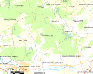
Arpheuilles
- commune in Cher, France
- Country:
- Postal Code: 18200
- Coordinates: 46° 46' 57" N, 2° 33' 38" E
- GPS tracks (wikiloc): [Link]
- Area: 48.01 sq km
- Population: 301

Saint-Amand-Montrond
- commune in Cher, France
- Country:
- Postal Code: 18200
- Coordinates: 46° 43' 22" N, 2° 30' 18" E
- GPS tracks (wikiloc): [Link]
- Area: 20.17 sq km
- Population: 9919
- Web site: [Link]


La Celle
- commune in Cher, France
- Country:
- Postal Code: 18200
- Coordinates: 46° 46' 7" N, 2° 26' 47" E
- GPS tracks (wikiloc): [Link]
- Area: 12.8 sq km
- Population: 347
Contres
- commune in Cher, France
- Country:
- Postal Code: 18130
- Coordinates: 46° 52' 5" N, 2° 29' 21" E
- GPS tracks (wikiloc): [Link]
- Area: 16.03 sq km
- Population: 33
Parnay
- commune in Cher, France
- Country:
- Postal Code: 18130
- Coordinates: 46° 50' 56" N, 2° 34' 15" E
- GPS tracks (wikiloc): [Link]
- Area: 17.28 sq km
- Population: 62
Uzay-le-Venon
- commune in Cher, France
- Country:
- Postal Code: 18190
- Coordinates: 46° 48' 44" N, 2° 27' 42" E
- GPS tracks (wikiloc): [Link]
- Area: 34.6 sq km
- Population: 399