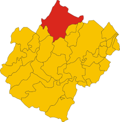
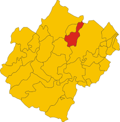
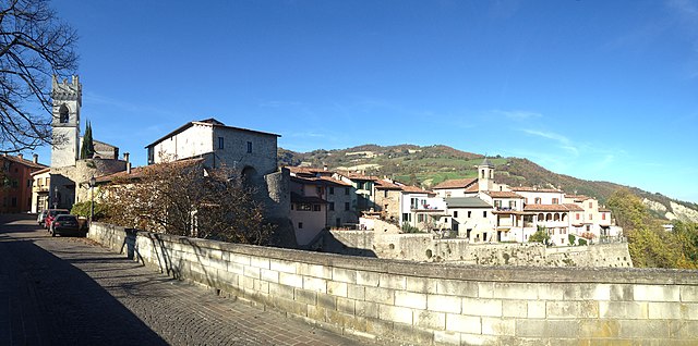
Meldola (Meldola)
.svg)
- Italian comune
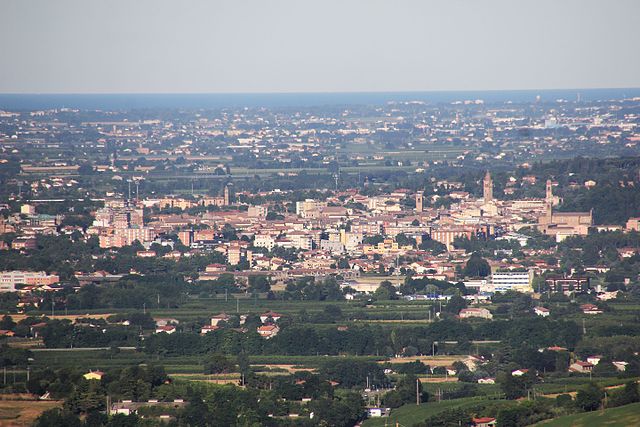
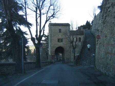
 Hiking in Meldola
Meldola, located in the Emilia-Romagna region of Italy, is surrounded by beautiful landscapes and offers some great opportunities for hiking enthusiasts. The area features rolling hills, vineyards, and picturesque countryside, which make for scenic trails.
Hiking Trails
-
Monte Eremo Trail: This moderate trail leads you up to Monte Eremo, providing stunning panoramic views of the surrounding area. The ascent can be steep in places, but the scenery is worth the effort.
-
Parco Nazionale delle Foreste Casentinesi: Though a bit farther from Meldola, this national park offers extensive hiking options with a variety of ecosystems, from extensive forests to mountainous terrain. It is designed for both casual and experienced hikers.
-
Wine and Vineyards Trails: Meldola is known for its winemaking, particularly Sangiovese. Many trails pass through vineyards, allowing you to enjoy the beautiful landscapes while getting a taste of local produce.
Seasonal Considerations
- Spring and Autumn: These seasons are ideal for hiking in Meldola. Temperatures are mild, and the landscape is vibrant with blooming flowers or autumn foliage.
- Summer: It can get quite hot, so early morning or late afternoon hikes are recommended to avoid the heat.
- Winter: Some trails may be less accessible due to snow, but if you’re equipped properly, winter hiking can offer a unique and serene experience.
Tips for Hiking in Meldola
- Local Guides: Consider hiring a local guide to learn more about the area, its flora, and fauna.
- Stay Hydrated: Always bring enough water, especially during the warmer months.
- Wear Appropriate Footwear: The terrain can be uneven, so sturdy hiking boots are advisable.
By exploring the trails around Meldola, not only will you get the chance to experience stunning scenery, but you will also get a taste of the local culture and perhaps enjoy a glass of wine post-hike at one of the local vineyards!
- Country:

- Postal Code: 47014
- Local Dialing Code: 0543
- Licence Plate Code: FC
- Coordinates: 44° 8' 0" N, 12° 4' 0" E


- GPS tracks (wikiloc): [Link]
- AboveSeaLevel: 58 м m
- Area: 79.08 sq km
- Population: 9978
- Web site: http://www.comune.meldola.fo.it
- Wikipedia en: wiki(en)
- Wikipedia: wiki(it)
- Wikidata storage: Wikidata: Q99945
- Wikipedia Commons Category: [Link]
- Freebase ID: [/m/0bd4_s]
- GeoNames ID: Alt: [6538491]
- VIAF ID: Alt: [145616808]
- OSM relation ID: [42847]
- MusicBrainz area ID: [4556e66a-362d-4410-ae9c-817c82420425]
- WOEID: [718178]
- UN/LOCODE: [ITLDA]
- ISTAT ID: 040019
- Italian cadastre code: F097
Shares border with regions:

Forlì
- Italian comune
Hiking in Forlì
Forlì, located in the Emilia-Romagna region of northern Italy, is surrounded by beautiful landscapes that are perfect for hiking enthusiasts. The area offers a mix of rolling hills, historical towns, and natural parks, making it an excellent destination for outdoor activities....
- Country:
- Postal Code: 47121–47122
- Local Dialing Code: 0543
- Licence Plate Code: FC; FO
- Coordinates: 44° 13' 21" N, 12° 2' 27" E
- GPS tracks (wikiloc): [Link]
- AboveSeaLevel: 34 м m
- Area: 228.2 sq km
- Population: 117859
- Web site: [Link]

Cesena
- Italian comune
Hiking in Cesena
Cesena is a beautiful town located in the Emilia-Romagna region of northern Italy. While it may not be as famous for hiking as some of the more mountainous regions in the country, there are still some delightful trails and natural areas that make for enjoyable hikes....
- Country:
- Postal Code: 47023; 47522; 47521
- Local Dialing Code: 0547
- Licence Plate Code: FC
- Coordinates: 44° 8' 0" N, 12° 14' 0" E
- GPS tracks (wikiloc): [Link]
- AboveSeaLevel: 44 м m
- Area: 249.47 sq km
- Population: 96583
- Web site: [Link]
Bertinoro
- Italian comune
Hiking in Bertinoro
Bertinoro, a picturesque town located in the Emilia-Romagna region of Italy, offers several rewarding hiking experiences thanks to its beautiful landscapes, rolling hills, and historical sites. Here's what you can expect while hiking in and around Bertinoro:...
- Country:
- Postal Code: 47032
- Local Dialing Code: 0543
- Licence Plate Code: FC
- Coordinates: 44° 9' 0" N, 12° 8' 0" E
- GPS tracks (wikiloc): [Link]
- AboveSeaLevel: 220 м m
- Area: 57.25 sq km
- Population: 10947
- Web site: [Link]

Civitella di Romagna
- Italian comune
Hiking in Civitella di Romagna
Civitella di Romagna is a charming village located in the Emilia-Romagna region of Italy, nestled in the heart of the Apennine mountains. The area offers stunning landscapes, beautiful trails, and a rich history, making it an excellent destination for hiking enthusiasts....
- Country:
- Postal Code: 47012
- Local Dialing Code: 0543
- Licence Plate Code: FC
- Coordinates: 44° 0' 0" N, 11° 56' 0" E
- GPS tracks (wikiloc): [Link]
- AboveSeaLevel: 219 м m
- Area: 117.93 sq km
- Population: 3758
- Web site: [Link]


Forlimpopoli
- Italian comune
Hiking in Forlimpopoli
Forlimpopoli, located in the Emilia-Romagna region of Italy, is a charming town known for its rich history, delicious cuisine, and beautiful landscapes. Hiking in and around Forlimpopoli can be a delightful experience, taking you through scenic countryside, rolling hills, and picturesque views....
- Country:
- Postal Code: 47034
- Local Dialing Code: 0543
- Licence Plate Code: FC
- Coordinates: 44° 11' 0" N, 12° 8' 0" E
- GPS tracks (wikiloc): [Link]
- AboveSeaLevel: 33 м m
- Area: 24.46 sq km
- Population: 13294
- Web site: [Link]


Predappio
- Italian comune
Hiking in Predappio
Predappio, located in the Emilia-Romagna region of Italy, is surrounded by beautiful countryside and offers various hiking opportunities. The area is characterized by rolling hills, wooded areas, and stunning views, making it a great destination for outdoor activities....
- Country:
- Postal Code: 47016
- Local Dialing Code: 0543
- Licence Plate Code: FC
- Coordinates: 44° 6' 15" N, 11° 59' 6" E
- GPS tracks (wikiloc): [Link]
- AboveSeaLevel: 133 м m
- Area: 91.39 sq km
- Population: 6287
- Web site: [Link]