Mesvres (Mesvres)

- commune in Saône-et-Loire, France
- Country:

- Postal Code: 71190
- Coordinates: 46° 51' 45" N, 4° 14' 31" E


- GPS tracks (wikiloc): [Link]
- Area: 23.46 sq km
- Population: 764
- Web site: http://www.mesvres.com
- Wikipedia en: wiki(en)
- Wikipedia: wiki(fr)
- Wikidata storage: Wikidata: Q1386588
- Wikipedia Commons Category: [Link]
- Wikipedia Commons Maps Category: [Link]
- Freebase ID: [/m/03qh0l4]
- Freebase ID: [/m/03qh0l4]
- GeoNames ID: Alt: [2994172]
- GeoNames ID: Alt: [2994172]
- SIREN number: [217102979]
- SIREN number: [217102979]
- BnF ID: [15273269w]
- BnF ID: [15273269w]
- INSEE municipality code: 71297
- INSEE municipality code: 71297
Shares border with regions:


La Chapelle-sous-Uchon
- commune in Saône-et-Loire, France
- Country:
- Postal Code: 71190
- Coordinates: 46° 50' 10" N, 4° 14' 0" E
- GPS tracks (wikiloc): [Link]
- Area: 16.59 sq km
- Population: 179


Étang-sur-Arroux
- commune in Saône-et-Loire, France
- Country:
- Postal Code: 71190
- Coordinates: 46° 51' 58" N, 4° 11' 22" E
- GPS tracks (wikiloc): [Link]
- Area: 34.63 sq km
- Population: 1910


Broye
- commune in Saône-et-Loire, France
- Country:
- Postal Code: 71190
- Coordinates: 46° 52' 17" N, 4° 17' 24" E
- GPS tracks (wikiloc): [Link]
- Area: 28.39 sq km
- Population: 754
- Web site: [Link]

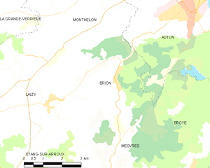
Brion
- commune in Saône-et-Loire, France
- Country:
- Postal Code: 71190
- Coordinates: 46° 54' 33" N, 4° 13' 39" E
- GPS tracks (wikiloc): [Link]
- Area: 16.57 sq km
- Population: 306


Saint-Symphorien-de-Marmagne
- commune in Saône-et-Loire, France
- Country:
- Postal Code: 71710
- Coordinates: 46° 50' 24" N, 4° 19' 49" E
- GPS tracks (wikiloc): [Link]
- Area: 37.31 sq km
- Population: 848
- Web site: [Link]

Autun
- commune in Saône-et-Loire, France
- Country:
- Postal Code: 71400
- Coordinates: 46° 57' 4" N, 4° 17' 55" E
- GPS tracks (wikiloc): [Link]
- AboveSeaLevel: 642 м m
- Area: 61.52 sq km
- Population: 13635
- Web site: [Link]