Meunet-Planches (Meunet-Planches)

- commune in Indre, France
- Country:

- Postal Code: 36100
- Coordinates: 46° 50' 14" N, 1° 57' 25" E


- GPS tracks (wikiloc): [Link]
- Area: 26.73 sq km
- Population: 178
- Wikipedia en: wiki(en)
- Wikipedia: wiki(fr)
- Wikidata storage: Wikidata: Q1137252
- Wikipedia Commons Category: [Link]
- Freebase ID: [/m/03nv9bj]
- GeoNames ID: Alt: [2994129]
- SIREN number: [213601214]
- BnF ID: [15257425c]
- PACTOLS thesaurus ID: [pcrtnORfQdFXnJ]
- INSEE municipality code: 36121
Shares border with regions:


Condé
- commune in Indre, France
- Country:
- Postal Code: 36100
- Coordinates: 46° 52' 44" N, 1° 59' 9" E
- GPS tracks (wikiloc): [Link]
- Area: 23.82 sq km
- Population: 251


Ambrault
- commune in Indre, France
- Country:
- Postal Code: 36120
- Coordinates: 46° 47' 5" N, 1° 57' 33" E
- GPS tracks (wikiloc): [Link]
- Area: 25.59 sq km
- Population: 903

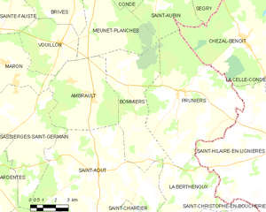
Bommiers
- commune in Indre, France
- Country:
- Postal Code: 36120
- Coordinates: 46° 47' 41" N, 1° 59' 7" E
- GPS tracks (wikiloc): [Link]
- Area: 28.38 sq km
- Population: 303


Vouillon
- commune in Indre, France
- Country:
- Postal Code: 36100
- Coordinates: 46° 49' 18" N, 1° 55' 29" E
- GPS tracks (wikiloc): [Link]
- Area: 14.98 sq km
- Population: 238


Thizay
- commune in Indre, France
- Country:
- Postal Code: 36100
- Coordinates: 46° 53' 53" N, 1° 54' 40" E
- GPS tracks (wikiloc): [Link]
- Area: 16.65 sq km
- Population: 238


Saint-Aubin
- commune in Indre, France
- Country:
- Postal Code: 36100
- Coordinates: 46° 51' 5" N, 2° 1' 27" E
- GPS tracks (wikiloc): [Link]
- Area: 28.32 sq km
- Population: 185


Brives
- commune in Indre, France
- Country:
- Postal Code: 36100
- Coordinates: 46° 50' 39" N, 1° 56' 50" E
- GPS tracks (wikiloc): [Link]
- Area: 19.61 sq km
- Population: 266