Michelbach, Lower Austria (Michelbach)

- municipality in Austria
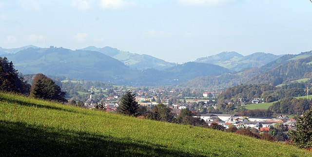
 Hiking in Michelbach, Lower Austria
Michelbach is a picturesque area in Lower Austria known for its beautiful landscapes, rolling hills, and access to various hiking trails that offer both beginners and experienced hikers opportunities to enjoy nature.
Hiking Trails in Michelbach
-
Local Trails: There are numerous well-marked hiking trails that wind through forests, vineyards, and over hills. These trails often provide stunning views of the surrounding countryside and are ideal for experiencing the natural beauty of Lower Austria.
-
Nature Walks: The area may have designated nature walking paths that focus on local flora and fauna, perfect for those who want a more leisurely hike.
-
Vineyard Trails: Given the region's wine production, some trails may take you through vineyards, allowing you to learn about the local viticulture while enjoying a scenic walk.
Preparation for Hiking
-
Gear: Make sure to wear comfortable footwear suitable for the terrain. Dress in layers to adapt to changing weather conditions, and bring along essentials such as water, snacks, and a first-aid kit.
-
Navigation: It’s beneficial to have a map or a hiking app to help you stay on track. Some trails may have signs, but having a GPS can be very helpful as well.
-
Weather Considerations: Always check the weather forecast before starting your hike, as conditions can change quickly in the mountains.
-
Local Etiquette: Respect nature and follow the Leave No Trace principles. Ensure that you're on marked paths to preserve the natural environment.
Best Time to Hike
The best time for hiking in Michelbach is typically in spring and autumn when the weather is mild, and the scenery is particularly beautiful. In spring, wildflowers bloom, and in autumn, you can enjoy the fall foliage.
Nearby Attractions
Aside from hiking, you can explore local attractions including historic sites, cultural landmarks, and opportunities for wine tasting in local vineyards—making it a great destination for a well-rounded outdoor experience.
Enjoy your adventure in Michelbach! Remember to take your time, soak in the views, and stay safe on the trails.
- Country:

- Postal Code: 3074
- Local Dialing Code: 02744
- Licence Plate Code: PL
- Coordinates: 48° 5' 0" N, 15° 45' 0" E


- GPS tracks (wikiloc): [Link]
- AboveSeaLevel: 376 м m
- Area: 24.95 sq km
- Population: 915
- Web site: http://www.michelbach.at/
- Wikipedia en: wiki(en)
- Wikipedia: wiki(de)
- Wikidata storage: Wikidata: Q680106
- Wikipedia Commons Category: [Link]
- Freebase ID: [/m/02r5f3j]
- GeoNames ID: Alt: [2771627]
- Austrian municipality key: [31923]
Shares border with regions:

Hainfeld
- municipality in Austria
Hiking in Hainfeld
Hainfeld, located in Lower Austria, is surrounded by picturesque landscapes, making it a great destination for hiking enthusiasts. The area offers various trails that cater to different skill levels, from easy walks through lush forests to more challenging hikes with steep ascents....
- Country:
- Postal Code: 3170
- Local Dialing Code: 02764
- Licence Plate Code: LF
- Coordinates: 48° 2' 0" N, 15° 46' 0" E
- GPS tracks (wikiloc): [Link]
- AboveSeaLevel: 439 м m
- Area: 44.73 sq km
- Population: 3726
- Web site: [Link]
Pyhra
- municipality in Austria
Hiking in Pyhra
Pyhra is a small town in Austria, located in the lower part of the country, close to the scenic landscapes of the Alps. While it may not be as widely known as some of the larger tourist destinations in Austria, it offers a wealth of opportunities for hiking enthusiasts....
- Country:
- Postal Code: 3143
- Local Dialing Code: 02745
- Licence Plate Code: PL
- Coordinates: 48° 9' 0" N, 15° 41' 0" E
- GPS tracks (wikiloc): [Link]
- AboveSeaLevel: 298 м m
- Area: 66.76 sq km
- Population: 3553
- Web site: [Link]
Stössing
- municipality in Austria
Hiking in Stössing
Stössing, a quaint village in the Lower Austria region, offers a variety of hiking opportunities that are perfect for both casual walkers and more experienced trekkers. The surrounding landscapes consist of rolling hills, lush forests, and picturesque views, making it an ideal destination for nature lovers....
- Country:
- Postal Code: 3073
- Local Dialing Code: 02744
- Licence Plate Code: PL
- Coordinates: 48° 7' 0" N, 15° 49' 0" E
- GPS tracks (wikiloc): [Link]
- AboveSeaLevel: 344 м m
- Area: 27.47 sq km
- Population: 838
- Web site: [Link]
Sankt Veit an der Gölsen
- municipality in Austria
Hiking in Sankt Veit an der Gölsen
Sankt Veit an der Gölsen, located in Lower Austria, offers a variety of hiking opportunities set against beautiful landscapes, including rolling hills, forests, and picturesque views. Here are some key points for hiking in this area:...
- Country:
- Postal Code: 3161
- Local Dialing Code: 02763
- Licence Plate Code: LF
- Coordinates: 48° 2' 0" N, 15° 40' 0" E
- GPS tracks (wikiloc): [Link]
- AboveSeaLevel: 369 м m
- Area: 78.14 sq km
- Population: 3915
- Web site: [Link]
Kasten bei Böheimkirchen
- municipality in Austria
Hiking in Kasten bei Böheimkirchen
Kasten bei Böheimkirchen is a charming village located in Lower Austria, surrounded by beautiful landscapes that are perfect for hiking enthusiasts. The area features a combination of picturesque countryside, rolling hills, and forests that make for a variety of hiking trails suitable for different skill levels....
- Country:
- Postal Code: 3072
- Local Dialing Code: 02744
- Licence Plate Code: PL
- Coordinates: 48° 9' 0" N, 15° 47' 0" E
- GPS tracks (wikiloc): [Link]
- AboveSeaLevel: 290 м m
- Area: 20.51 sq km
- Population: 1409
- Web site: [Link]