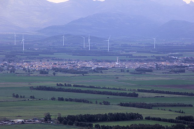
Mogoro (Mogoro)
%20-%202016.svg)
- Italian comune
 Hiking in Mogoro
Mogoro, located in the Oristano province of Sardinia, Italy, offers a unique hiking experience that combines stunning landscapes, rich cultural heritage, and diverse ecosystems. The region is characterized by beautiful rolling hills, scenic countryside, and proximity to the coast, making it ideal for a variety of outdoor activities.
Hiking Trails:
-
Su Mulinu Trail: This trail is popular among local hikers and takes you through oak forests and rocky terrains, offering panoramic views of the surrounding landscape. It's an excellent trail for both beginners and experienced hikers.
-
Mount Arci: Located nearby, this area provides several hiking routes with varying difficulty levels. The trails often lead to breathtaking vistas and the chance to explore diverse flora and fauna, including endemic species.
-
Coastal Trails: The coastline near Mogoro features trails that offer stunning views of the Mediterranean Sea. The walk along the coast also allows for the opportunity to visit hidden coves and beaches, making it perfect for a mixed hiking and swimming adventure.
Tips for Hiking in Mogoro:
- Season: The best time to hike in the Mogoro area is during the spring (April to June) and autumn (September to October) when the weather is mild and the trails are less crowded.
- Equipment: Wear sturdy hiking boots, and bring plenty of water, snacks, and sun protection. A local map or GPS device can also be useful to navigate the trails.
- Wildlife: Keep an eye out for local wildlife, including various bird species and unique plants, particularly around the Mount Arci area.
- Respect Nature: Follow the Leave No Trace principles. Stay on designated trails to preserve the natural beauty of the area.
Cultural Insights:
Mogoro is known for its traditional crafts, especially weaving. After a day of hiking, consider visiting local artisans or galleries to appreciate the culture and perhaps pick up a handmade souvenir.
Conclusion:
Hiking in Mogoro offers a blend of natural beauty and cultural experiences, making it an excellent destination for outdoor enthusiasts. Whether you choose a peaceful forest trail or a more challenging coastal path, the region's stunning landscapes are sure to leave a lasting impression.
- Country:

- Postal Code: 09095
- Local Dialing Code: 0783
- Licence Plate Code: OR
- Coordinates: 39° 41' 6" N, 8° 46' 37" E


- GPS tracks (wikiloc): [Link]
- AboveSeaLevel: 186 м m
- Area: 48.99 sq km
- Population: 4118
- Web site: http://www.comune.mogoro.or.it
- Wikipedia en: wiki(en)
- Wikipedia: wiki(it)
- Wikidata storage: Wikidata: Q386643
- Wikipedia Commons Category: [Link]
- Freebase ID: [/m/0gr0j9]
- GeoNames ID: Alt: [6539363]
- OSM relation ID: [40022]
- UN/LOCODE: [ITMG2]
- ISTAT ID: 095029
- Italian cadastre code: F272
Shares border with regions:


Collinas
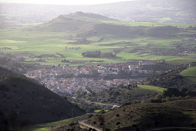
- Italian comune
Hiking in Collinas
It looks like you may be referring to the Collinas region, which could indicate several places, as "Collinas" might refer to a general term for "hills" in Spanish or Italian, or it may refer to a specific area, such as the Collinas area in Sardinia, Italy. However, since you didn’t specify a location, I'll share general tips and information about hiking in hilly or mountainous regions....
- Country:
- Postal Code: 09020
- Local Dialing Code: 070
- Licence Plate Code: SU
- Coordinates: 39° 38' 26" N, 8° 50' 24" E
- GPS tracks (wikiloc): [Link]
- AboveSeaLevel: 249 м m
- Area: 20.83 sq km
- Population: 829
- Web site: [Link]

Pabillonis
- Italian comune
Hiking in Pabillonis
Pabillonis is a small town located in the province of South Sardinia, Italy. While it may not be as widely known for hiking as other parts of Sardinia, the surrounding region offers some beautiful landscapes and opportunities for outdoor activities....
- Country:
- Postal Code: 09030
- Local Dialing Code: 070
- Licence Plate Code: SU
- Coordinates: 39° 35' 33" N, 8° 43' 18" E
- GPS tracks (wikiloc): [Link]
- AboveSeaLevel: 42 м m
- Area: 37.42 sq km
- Population: 2717
- Web site: [Link]


Sardara
- Italian comune
Hiking in Sardara
Sardara is a charming town located in the province of South Sardinia, Italy. Nestled in a region rich with natural beauty, ancient history, and a diversity of landscapes, hiking in and around Sardara can be a wonderful experience for outdoor enthusiasts. Here are some highlights and tips for hiking in the area:...
- Country:
- Postal Code: 09030
- Local Dialing Code: 070
- Licence Plate Code: SU
- Coordinates: 39° 36' 50" N, 8° 49' 17" E
- GPS tracks (wikiloc): [Link]
- AboveSeaLevel: 163 м m
- Area: 56.23 sq km
- Population: 4033
- Web site: [Link]

Gonnostramatza
- Italian comune
Hiking in Gonnostramatza
Hiking in Gonnostramatza, a municipality in the province of Oristano in Sardinia, Italy, offers a unique experience for outdoor enthusiasts. The region is known for its stunning natural landscapes, rich history, and diverse flora and fauna....
- Country:
- Postal Code: 09093
- Local Dialing Code: 0783
- Licence Plate Code: OR
- Coordinates: 39° 40' 54" N, 8° 49' 58" E
- GPS tracks (wikiloc): [Link]
- AboveSeaLevel: 104 м m
- Area: 17.64 sq km
- Population: 879
- Web site: [Link]


Masullas
- Italian comune
Hiking in Masullas
Masullas is a charming village located in the province of Oristano in Sardinia, Italy. It's not as well-known as some other hiking destinations, but it offers beautiful landscapes and a unique experience for outdoor enthusiasts....
- Country:
- Postal Code: 09090
- Local Dialing Code: 0783
- Licence Plate Code: OR
- Coordinates: 39° 42' 0" N, 8° 47' 3" E
- GPS tracks (wikiloc): [Link]
- AboveSeaLevel: 129 м m
- Area: 18.68 sq km
- Population: 1061
- Web site: [Link]


San Nicolò d'Arcidano
- Italian comune
Hiking in San Nicolò d'Arcidano
San Nicolò d'Arcidano is a charming town located in the province of Oristano, Sardinia, Italy. Surrounded by beautiful landscapes, it offers various opportunities for hiking and exploring the natural beauty of the region....
- Country:
- Postal Code: 09097
- Local Dialing Code: 0783
- Licence Plate Code: OR
- Coordinates: 39° 41' 1" N, 8° 38' 48" E
- GPS tracks (wikiloc): [Link]
- AboveSeaLevel: 13 м m
- Area: 28.36 sq km
- Population: 2630
- Web site: [Link]


Terralba
- Italian comune
Hiking in Terralba
Terralba is a small town located in the province of Oristano in Sardinia, Italy. The area around Terralba offers a variety of hiking opportunities, characterized by stunning landscapes, rich natural diversity, and historical sites....
- Country:
- Postal Code: 09098
- Local Dialing Code: 0783
- Licence Plate Code: OR
- Coordinates: 39° 43' 11" N, 8° 38' 11" E
- GPS tracks (wikiloc): [Link]
- AboveSeaLevel: 9 м m
- Area: 49.8 sq km
- Population: 10196
- Web site: [Link]


Uras
- Italian comune
Hiking in Uras
Uras is a small town located in the province of Oristano in Sardinia, Italy. While it may not be as famous as some other Italian hiking destinations, it serves as a gateway to exploring the beautiful natural landscapes of Sardinia. The area is characterized by rolling hills, rugged terrain, and picturesque views, making it a great spot for hiking enthusiasts. Here are some aspects to consider if you're planning to hike in and around Uras:...
- Country:
- Postal Code: 09099
- Local Dialing Code: 0783
- Licence Plate Code: OR
- Coordinates: 39° 41' 54" N, 8° 42' 5" E
- GPS tracks (wikiloc): [Link]
- AboveSeaLevel: 23 м m
- Area: 39.24 sq km
- Population: 2825
- Web site: [Link]